Geo-Spatial Agriculture Analytics Market Size, Share & Growth Analysis, 2026-2034
Geo-Spatial Agriculture Analytics Market Size, Share & Growth Analysis, 2026-2034
Segments - by Component (Software, Hardware, Services), by Application (Crop Monitoring, Soil Analysis, Irrigation Management, Yield Prediction, Field Mapping, Others), by Deployment Mode (On-Premises, Cloud), by Farm Size (Small and Medium Farms, Large Farms), by End-User (Agricultural Cooperatives, Agribusinesses, Research Institutes, Government Agencies, Others)



Last Updated : Jun, 2026
| Report ID :FB-12055
| 4.9 Rating
| 88 Reviews
| 283 Pages
| Format :


Geo-Spatial Agriculture Analytics Market: Key Numbers
The Geo-Spatial Agriculture Analytics market was valued at USD 2.19 Billion in 2025 and is projected to reach USD 6.56 Billion by 2034, a CAGR of 13%.
| Market size (2025) | USD 2.19 Billion |
|---|---|
| Forecast (2034) | USD 6.56 Billion |
| CAGR (2026-2034) | 13% |
| Largest region | North America (37% share) |
| Segments covered | Component, Application, Deployment Mode, Farm Size, End-User |
| Key companies | Trimble Inc., Deere & Company (John Deere), Ag Leader Technology, Climate LLC (A subsidiary of Bayer AG), Topcon Positioning Systems |
This report is updated with the latest market data and insights as of June 2026. Base year: 2025 | Forecast period: 2026-2034
Geo-Spatial Agriculture Analytics Market Size and Growth Outlook
The global Geo-Spatial Agriculture Analytics market size reached USD 2.19 billion in 2025 and is projected to grow at a robust CAGR of 13.0% during the forecast period, reaching approximately USD 6.56 billion by 2034. This remarkable growth trajectory is driven by accelerating adoption of precision agriculture technologies, the proliferation of IoT-enabled field devices, and the growing imperative for sustainable and climate-resilient farming practices. The market is witnessing intensified digital transformation investment across the agricultural value chain, as farmers, agribusinesses, and policymakers recognize the tangible value of geo-spatial analytics in optimizing crop yields, managing resources, and improving supply chain efficiency.

One of the primary growth factors fueling this market is the rising demand for enhanced crop productivity and smarter resource management. As global food demand intensifies due to population growth and worsening climate variability, farmers and agribusinesses are increasingly turning to advanced analytics for informed, real-time decision-making. Geo-spatial analytics leverages satellite imagery, remote sensing, and GIS-based solutions to deliver actionable insights into soil health, crop status, and environmental conditions. This data-driven approach enables precision interventions, minimizes input wastage, and supports sustainable agriculture practices. Platforms now incorporating AI-powered precision agriculture capabilities are delivering especially strong productivity gains for both smallholder and commercial farming operations.
Rapid technological advancement, particularly the integration of artificial intelligence and machine learning within geo-spatial platforms, is another significant driver. Modern solutions increasingly use AI-driven algorithms to process vast, multi-source datasets, predict crop yields, and detect anomalies in field conditions. These capabilities support early warning systems for pest infestations, disease outbreaks, and water stress, allowing for timely and targeted interventions. The integration of drones, UAVs, and IoT sensors with geo-spatial analytics platforms enables granular real-time data collection across large tracts of farmland. As technology costs continue to decline and accessibility improves, adoption rates among farmers and agribusinesses are expected to rise significantly through the forecast period. Solutions covering drone-based agricultural analytics are a particularly fast-growing area, enabling field-level precision that was previously unachievable at scale.
Government initiatives and policy frameworks promoting digital agriculture are also key contributors to market growth. Numerous countries have launched programs to subsidize the adoption of precision farming tools, including geo-spatial analytics, to address food security challenges and strengthen agricultural resilience. These initiatives are complemented by collaborations between research institutes, technology providers, and agricultural cooperatives to develop localized, agro-climatically relevant solutions. The increasing availability of open-source satellite data and the expansion of broadband connectivity in rural areas are further catalyzing adoption, narrowing the digital divide, and empowering farmers with previously inaccessible analytical insights.
Imagery analytics for agriculture is increasingly becoming a cornerstone of the geo-spatial agriculture analytics ecosystem. By utilizing high-resolution satellite and aerial imagery, farmers can gain unprecedented visibility into crop health, soil conditions, and environmental factors affecting their fields. This technology enables detection of subtle changes in crop patterns that may indicate stress, nutrient deficiency, or emerging disease, allowing timely and targeted interventions. The integration of imagery analytics with IoT sensor networks and weather forecast data enhances the precision and reliability of agricultural models. As satellite data accessibility expands and image processing algorithms advance, imagery analytics is becoming an essential tool for modern farmers seeking to improve productivity and build climate resilience.
From a regional perspective, North America currently dominates the Geo-Spatial Agriculture Analytics market, accounting for the largest revenue share in 2025. The region's leadership reflects early technology adoption, strong government support, and the presence of major industry players. Asia Pacific is the fastest-growing market, driven by large-scale agricultural activity, rising agri-tech investment, and supportive policy environments in China, India, and Australia. Europe holds a significant market share, propelled by stringent sustainability regulations, the EU Green Deal, and a robust research ecosystem. Latin America and the Middle East and Africa are witnessing steady growth, fueled by modernization efforts and increasing awareness of precision agriculture benefits.
Geo-Spatial Agriculture Analytics Market by Component
The Geo-Spatial Agriculture Analytics market is segmented by component into Software, Hardware, and Services, each playing a pivotal role in the ecosystem. The software segment, representing approximately 45.5% of total market revenue in 2025, encompasses platforms and applications that process, integrate, and visualize geo-spatial data to deliver actionable insights. These solutions include Geographic Information Systems (GIS), remote sensing analytics engines, and farm management platforms that aggregate diverse data streams for comprehensive field-level analysis. Growing demand for user-friendly, scalable, and interoperable software is driving innovation in this segment, with vendors prioritizing cloud-native architectures and AI-powered analytics to enhance performance and broaden accessibility. The rise of specialized crop analytics software is a notable trend, enabling granular, crop-specific insights that support precision intervention strategies.

The hardware segment, holding roughly 32% of market share in 2025, includes GPS receivers, drones, UAVs, multispectral sensors, and satellite imaging equipment that facilitate data collection directly in the field. The proliferation of affordable, high-precision hardware has significantly reduced entry barriers for farmers and agribusinesses, enabling real-time monitoring and data acquisition across vast tracts of farmland. IoT-enabled sensors integrated with geo-spatial analytics platforms allow continuous tracking of soil moisture, nutrient levels, and crop health indicators, supporting timely data-driven decisions. As hardware becomes more compact, energy-efficient, and cost-effective, its adoption is accelerating, particularly across emerging markets in Asia Pacific and Latin America.
Services account for approximately 22.5% of the market in 2025, encompassing consulting, system implementation, customization, training, and ongoing technical support. These services are essential for ensuring successful deployment and meaningful integration of geo-spatial analytics within existing agricultural workflows. As platform complexity grows, demand for specialized services including data management, predictive model development, and agronomic advisory is rising sharply. Service providers are also playing a vital role in educating end-users and building digital capacity, particularly among smallholder farming communities, thereby driving sustainable long-term adoption and maximizing return on investment across the market.
The interplay between software, hardware, and services is actively shaping the competitive landscape. Leading vendors are increasingly offering integrated solutions that combine advanced analytics software with state-of-the-art hardware and comprehensive support services. This holistic approach streamlines implementation, enhances the overall value proposition, and builds stronger customer relationships. As the market matures, partnerships between software developers, hardware manufacturers, and service providers are intensifying, driving cross-sector innovation and expanding market reach. The growing role of SAR satellite analytics in agriculture is also creating new opportunities for hardware-software integration, particularly for all-weather field monitoring applications that complement optical satellite data.
Geo-Spatial Agriculture Analytics Market Report Scope
| Attributes | Details |
| Report Title | Geo-Spatial Agriculture Analytics Market Research Report 2034 |
| By Component | Software, Hardware, Services |
| By Application | Crop Monitoring, Soil Analysis, Irrigation Management, Yield Prediction, Field Mapping, Others |
| By Deployment Mode | On-Premises, Cloud |
| By Farm Size | Small and Medium Farms, Large Farms |
| By End-User | Agricultural Cooperatives, Agribusinesses, Research Institutes, Government Agencies, Others |
| Regions Covered | North America, Europe, APAC, Latin America, MEA |
| Base Year | 2025 |
| Historic Data | 2019-2024 |
| Forecast Period | 2026-2034 |
| Number of Pages | 283 |
| Number of Tables & Figures | 269 |
| Customization Available | Yes, the report can be customized as per your need. |
Geo-Spatial Agriculture Analytics Market by Application
The application landscape for Geo-Spatial Agriculture Analytics is broad and diversifying, with key segments including Crop Monitoring, Soil Analysis, Irrigation Management, Yield Prediction, Field Mapping, and Others. Crop monitoring remains the largest application area in 2025, leveraging satellite imagery, drone surveillance, and distributed sensor networks to track crop growth stages, detect stress factors, and guide input application with high precision. The ability to monitor crops continuously at scale is transforming traditional farming workflows, enabling proactive interventions that minimize crop losses and maximize yield potential. As climate variability intensifies and pest pressure increases, crop monitoring has become indispensable for commercial and smallholder farmers alike.
Soil analysis is a critical and growing application, utilizing geo-spatial data to assess soil health, nutrient levels, pH, and moisture content across distinct field zones. By generating high-resolution soil variability maps, farmers can implement targeted fertilization and precision irrigation strategies that reduce input costs and environmental impact. Advanced analytics platforms now integrate multi-spectral satellite data with ground-based sensor readings and laboratory analysis to deliver detailed soil health profiles. This precision approach supports sustainable land management, helping address pressing issues such as soil degradation, nutrient runoff, and long-term fertility decline that affect agricultural productivity globally.
Irrigation management leverages geo-spatial analytics to optimize water usage, a priority concern in regions experiencing accelerating water scarcity. By correlating weather pattern data, soil moisture readings, evapotranspiration models, and crop water demand profiles, these solutions enable precise scheduling and spatial allocation of irrigation resources. Smart irrigation systems integrated with geo-spatial platforms are gaining rapid traction among progressive farmers aiming to improve water use efficiency and reduce energy costs. The related field of AI-driven agri-weather analytics is increasingly being used alongside irrigation management modules to deliver localized, forecast-driven irrigation scheduling that adapts dynamically to changing conditions.
Yield prediction and field mapping are high-value applications gaining significant momentum through the forecast period. Yield prediction models integrate historical performance data, real-time satellite observations, weather forecasts, and agronomic parameters to generate reliable crop output estimates that support financial planning, procurement, and risk management. Field mapping provides precise spatial representations of farm boundaries, infrastructure, drainage patterns, and field variability zones, facilitating efficient resource allocation and supporting compliance with evolving regulatory requirements. Other applications including pest and disease early detection, supply chain traceability, and farm equipment telematics are also growing in prominence as geo-spatial platform capabilities continue to evolve.
Geo-Spatial Agriculture Analytics Market by Deployment Mode
Deployment mode is a critical decision factor for end-users in the Geo-Spatial Agriculture Analytics market, with two primary options: On-Premises and Cloud solutions. On-premises deployment remains relevant among large-scale agribusinesses and government agencies that require full control over data security, infrastructure customization, and integration with legacy enterprise systems. These organizations typically possess the resources and in-house expertise to manage complex IT environments and are often operating in jurisdictions with stringent data sovereignty requirements. On-premises solutions are particularly prevalent in North America and Europe, where data privacy regulations are well-established and enforced.
Cloud-based deployment is the dominant and fastest-growing mode in 2025, driven by its inherent scalability, flexibility, and significantly lower total cost of ownership. Cloud solutions enable farmers and agribusinesses of all sizes to access sophisticated analytics capabilities without large upfront capital expenditure on hardware or dedicated IT staff. The pay-as-you-go and subscription pricing models offered by cloud vendors are particularly attractive to small and medium farms, which constitute a substantial share of the global farming landscape. Cloud platforms also facilitate seamless real-time data sharing, multi-stakeholder collaboration, and integration with mobile applications and farm management systems, enhancing overall operational efficiency.
The ongoing expansion of cloud infrastructure in rural and semi-rural areas, combined with improving mobile broadband coverage, is steadily removing historical connectivity barriers to cloud adoption. Leading vendors are investing in advanced security protocols, data encryption, and regulatory compliance features to address lingering concerns about data privacy and ownership, making cloud deployment increasingly viable for a broader range of end-users including cooperatives and government agencies. The integration of cloud-based geo-spatial analytics with broader digital agriculture ecosystems, including equipment telematics, market intelligence, and financial services platforms, is creating compelling network effects that further reinforce cloud adoption.
Hybrid deployment models that blend on-premises data management with cloud-based processing and analytics are gaining traction among large enterprises and cooperatives seeking to balance data control with scalability. These models allow organizations to retain sensitive proprietary data within controlled environments while accessing cloud computing power for intensive analytics workloads and collaborative functions. As agricultural data volumes grow exponentially alongside the proliferation of field sensors, satellites, and autonomous machinery, demand for flexible and resilient deployment architectures is expected to accelerate, shaping the long-term evolution of the market through 2034.
Geo-Spatial Agriculture Analytics Market by Farm Size
The Geo-Spatial Agriculture Analytics market is segmented by farm size into Small and Medium Farms and Large Farms, each presenting distinct adoption dynamics and product requirements. Small and medium farms represent a substantial and underserved market opportunity, particularly across developing regions of Asia, Africa, and Latin America where smallholder agriculture dominates the rural economy. These farms frequently face resource constraints, limited technology access, and knowledge gaps that have historically impeded adoption of advanced analytics tools. However, the proliferation of affordable mobile-based platforms, localized advisory services, and government-backed digitalization programs is progressively bridging this gap, enabling smallholder farmers to benefit from data-driven insights.
Large farms are established early adopters of advanced geo-spatial analytics, leveraging their scale, financial resources, and organizational capacity to implement comprehensive precision agriculture strategies. Operating across vast land areas with diverse crop portfolios, large farms derive substantial value from satellite imagery, drone surveillance, and IoT-enabled monitoring networks that provide granular, continuous field intelligence. The ability to aggregate, integrate, and analyze large datasets supports advanced applications including predictive yield modeling, multi-field performance benchmarking, and logistics optimization, delivering measurable ROI that justifies significant technology investment.
Adoption among small and medium farms is being actively facilitated through innovative business models such as pay-per-use analytics, cooperative technology procurement programs, and mobile-first application design tailored to low-bandwidth environments. NGO partnerships and government extension programs are also playing an important role in building digital literacy and demonstrating the practical value of geo-spatial analytics to skeptical smallholders. As technology providers increasingly recognize the growth potential in this segment, product roadmaps and go-to-market strategies are being adapted to address affordability, usability, and local language requirements.
For large farms, the strategic focus is shifting toward deep integration of geo-spatial analytics with enterprise resource planning systems, commodity trading platforms, and sustainability reporting frameworks. End-to-end digital integration enables comprehensive visibility and control from field operations through to post-harvest processing and market delivery. As sustainability credentials become an increasingly important competitive differentiator and regulatory requirement, large farm operators are investing in geo-spatial analytics capabilities that support carbon footprint monitoring, biodiversity assessment, and responsible land use documentation, creating new demand vectors within this segment.
Geo-Spatial Agriculture Analytics Market by End-User
The end-user landscape for Geo-Spatial Agriculture Analytics encompasses Agricultural Cooperatives, Agribusinesses, Research Institutes, Government Agencies, and Others. Agricultural cooperatives play an increasingly important role in democratizing technology access, aggregating member demand, and negotiating favorable terms with analytics platform providers. By pooling resources and sharing infrastructure costs, cooperatives enable even small member farms to access geo-spatial analytics capabilities that would otherwise be financially out of reach. Cooperatives also serve as trusted knowledge networks, facilitating peer-to-peer learning and structured training programs that build members' capacity to generate actionable value from analytics tools.
Agribusinesses, encompassing large-scale producers, processors, commodity traders, and distributors, represent the largest and most financially significant end-user segment. These organizations are applying geo-spatial analytics across the full value chain, from field-level crop monitoring and yield forecasting through to supply chain optimization, traceability documentation, and sustainability reporting. The ability to monitor field conditions in real time, predict production volumes accurately, and manage logistics dynamically is fundamentally transforming agribusiness operations. As consumer and regulatory demand for transparent, sustainably produced food intensifies, agribusinesses are expected to further accelerate their investment in geo-spatial analytics through the forecast period.
Research institutes and academic organizations continue to drive fundamental innovation in geo-spatial agriculture analytics, developing novel algorithms, remote sensing methodologies, and crop modeling frameworks that advance the state of the art. These institutions frequently collaborate with technology vendors, government agencies, and industry partners to pilot, validate, and scale new analytical solutions. The outputs of agricultural research directly inform policy development, investment prioritization, and best practice dissemination, making research institutes indispensable contributors to the long-term health and advancement of the market ecosystem.
Government agencies function as both significant end-users and critical market enablers, deploying geo-spatial analytics for national food security monitoring, agricultural census modernization, disaster response planning, and climate adaptation programs. By investing in satellite data infrastructure, providing technology adoption incentives, and establishing open data platforms, governments are creating enabling environments that catalyze broader market adoption. Other end-users including development finance institutions, crop insurance providers, and agricultural NGOs are also growing in prominence, particularly in applying geo-spatial analytics to expand financial inclusion and improve risk management for underserved farming communities across emerging markets.
Geo-Spatial Agriculture Analytics Market Opportunities and Threats
The Geo-Spatial Agriculture Analytics market presents substantial opportunities for innovation and value creation, driven by the convergence of advanced digital technologies with urgent global imperatives around food security and environmental sustainability. One of the most compelling opportunities lies in the development of truly integrated analytics ecosystems that combine real-time satellite data streams, IoT sensor networks, AI-driven decision support, and agronomic advisory services into unified, accessible platforms. The ongoing expansion of rural broadband and mobile connectivity is unlocking new addressable markets, particularly across South and Southeast Asia, Sub-Saharan Africa, and Latin America, where digital agriculture adoption is still in early stages. The growing global emphasis on climate-smart farming, carbon sequestration measurement, and regenerative agricultural practices is further creating robust demand for analytics tools that support environmental performance tracking and compliance with evolving international sustainability standards.
The rise of data-driven agricultural insurance and precision lending represents another high-impact opportunity. By leveraging geo-spatial analytics, insurers and agricultural finance institutions can assess field-level risk with unprecedented accuracy, design parametric products triggered by satellite-observed conditions, and streamline claims processing without costly physical inspections. This capability significantly enhances financial product accessibility for smallholder farmers who have historically been excluded from formal insurance and credit markets. The convergence of geo-spatial analytics with emerging technologies including edge computing, 5G connectivity, and distributed ledger systems is expected to enable new real-time data exchange architectures, enhanced supply chain traceability, and novel value-sharing business models between technology providers, farmers, and downstream buyers through the 2026-2034 forecast period.
Despite the breadth of opportunity, the market faces meaningful challenges that must be addressed for sustainable long-term growth. Data privacy, ownership, and security concerns represent a significant restraint, particularly as the volume and sensitivity of geo-spatial farm data collected by commercial platforms grows. Questions about who controls farmer data, how it may be used, and what protections exist against misuse are increasingly salient to end-users. The substantial upfront investment required for advanced analytics implementations, combined with persistent digital literacy gaps among rural farming populations, continues to impede adoption across lower-income markets. Fragmented data standards, interoperability barriers between competing platforms, and limited availability of high-quality, locally calibrated training data for AI models are additional structural challenges that the industry must collectively resolve to realize its full growth potential through 2034.
Geo-Spatial Agriculture Analytics Market Size by Region
North America remains the largest regional market for Geo-Spatial Agriculture Analytics, accounting for approximately 37% of global revenue in 2025, representing roughly USD 810 million. The region's sustained leadership reflects deep-rooted precision agriculture culture, strong government investment in agricultural digitalization, and the concentration of major technology vendors and agri-tech venture capital activity. The United States and Canada are at the forefront of market development, with farmers increasingly integrating geo-spatial analytics into standard farm management workflows. Ongoing investments in satellite data infrastructure, AI model development, and platform interoperability standards are expected to maintain North America's leadership position, even as other regions close the gap during the forecast period.

Asia Pacific is the fastest-growing regional market, with a projected CAGR of approximately 16.8% from 2026 to 2034. The region is expected to surpass USD 2.3 billion by 2034, driven by the enormous scale of agricultural activity across China, India, and Southeast Asia, combined with rapidly rising investment in agri-tech and strong government digital agriculture mandates. India's national digital agriculture mission, China's smart farming initiatives, and Australia's advanced precision agriculture ecosystem are all contributing to accelerating adoption. The rapid proliferation of smartphones, improving rural connectivity, and decreasing hardware costs are particularly important enablers for the region's large smallholder farming population. Expanding applications of satellite imagery in agriculture across the region are delivering field-level insights at scale that were previously unavailable to Asian farmers.
Europe holds approximately 23.5% of global revenue in 2025, with growth sustained by stringent environmental and sustainability regulations, the EU Common Agricultural Policy framework, and active public investment in agricultural innovation through programs such as Horizon Europe. The EU Green Deal and Farm to Fork strategy are creating strong regulatory pull for geo-spatial analytics tools that support precision nutrient management, biodiversity monitoring, and carbon reporting. Latin America, led by Brazil and Argentina, is witnessing steady growth as large-scale commercial agriculture operations invest in analytics to improve competitive efficiency and meet export market sustainability requirements. The Middle East and Africa, while currently the smallest regional market, presents strong long-term growth potential as governments prioritize food security investments, water management modernization, and broader digital infrastructure development across agricultural regions.
Geo-Spatial Agriculture Analytics Market Competitive Landscape
The competitive landscape of the Geo-Spatial Agriculture Analytics market in 2025 is characterized by a dynamic mix of established technology leaders, specialized agri-tech innovators, and emerging regional players. Established companies are pursuing aggressive strategies involving product portfolio expansion, strategic acquisitions, and deep R&D investment to consolidate their market positions. Simultaneously, a vibrant cohort of well-funded startups is challenging incumbents with innovative AI-first platforms, novel data monetization models, and hyper-localized solutions designed for specific crop types or agro-climatic zones. The pace of technological change, particularly in AI-driven analytics and next-generation satellite constellations, is keeping competitive intensity high across all market segments.
Strategic partnerships between geo-spatial analytics vendors and agricultural input companies, equipment manufacturers, and commodity trading platforms are playing an increasingly important role in expanding market reach and creating integrated value propositions that are difficult for competitors to replicate. These ecosystem-level collaborations enable end-to-end solutions that address the full complexity of modern agricultural operations, from seed selection and field preparation through to harvest, storage, and market delivery. Competition for data partnerships, particularly access to proprietary satellite constellations, high-density IoT sensor networks, and farm management system integrations, is becoming a key determinant of competitive advantage as data quality and breadth differentiates analytics outcomes.
Pricing strategies, platform openness, and the ability to demonstrate clear, measurable ROI are central competitive differentiators in 2025. Subscription-based and outcome-linked pricing models are gaining prominence, aligning vendor incentives with farmer success and reducing adoption risk for end-users. The increasing demand for multi-language, mobile-optimized interfaces and offline-capable functionality reflects the growing importance of emerging market segments where connectivity and device access remain constraints. As the overall market continues to mature and consolidate, the ability to deliver consistently reliable, actionable insights across diverse crop types, geographies, and farm sizes will separate market leaders from followers through the 2026-2034 forecast period.
Among the major companies active in the Geo-Spatial Agriculture Analytics market, Trimble Inc. continues to lead with comprehensive precision agriculture platforms integrating GPS, GIS, and advanced field analytics. Deere and Company has made substantial investments in digital agriculture, embedding geo-spatial intelligence into its Connected Operations ecosystem. Topcon Positioning Systems and Hexagon AB maintain strong positions in high-precision field mapping and surveying. Esri's ArcGIS platform remains a foundational tool for GIS-based agricultural analysis across government and research applications. Climate LLC (a Bayer subsidiary) and Granular (a Corteva company) are prominent in AI-driven crop management and farm data analytics. Planet Labs PBC continues to expand its commercial satellite constellation, providing foundational imagery that underpins many third-party analytics platforms. CropX Technologies, Sentera, Farmers Edge, SatSure Analytics, OneSoil, and Taranis represent a dynamic tier of specialized innovators addressing targeted application needs within the broader market ecosystem. The broader expansion of the digital agriculture market is providing favorable tailwinds for all these players as farm digitalization accelerates globally.
Top Companies in the Geo-Spatial Agriculture Analytics Market
- Trimble Inc.
- Deere & Company (John Deere)
- Ag Leader Technology
- Climate LLC (A subsidiary of Bayer AG)
- Topcon Positioning Systems
- Planet Labs PBC
- CropX Technologies
- AgEagle Aerial Systems
- Sentera
- Farmers Edge
- Esri
- SatSure Analytics
- OneSoil
- Granular (A Corteva Agriscience Company)
- Taranis (A Bayer Digital Farming Brand)
- Geosys (A Telespazio Company)
- Hexagon AB
- PrecisionHawk
Segments
The Geo-Spatial Agriculture Analytics market has been segmented on the basis of
Component
- Software
- Hardware
- Services
Application
- Crop Monitoring
- Soil Analysis
- Irrigation Management
- Yield Prediction
- Field Mapping
- Others
Deployment Mode
- On-Premises
- Cloud
Farm Size
- Small and Medium Farms
- Large Farms
End-User
- Agricultural Cooperatives
- Agribusinesses
- Research Institutes
- Government Agencies
- Others
Frequently Asked Questions
Leading companies in the global Geo-Spatial Agriculture Analytics market as of 2025 include Trimble Inc., Deere & Company (John Deere), Ag Leader Technology, Climate LLC (a Bayer subsidiary), Topcon Positioning Systems, Planet Labs PBC, CropX Technologies, AgEagle Aerial Systems, Sentera, Farmers Edge, Esri, SatSure Analytics, OneSoil, Granular (a Corteva Agriscience company), Taranis, Geosys (a Telespazio company), Hexagon AB, and PrecisionHawk. These companies are driving innovation through AI integration, strategic partnerships, and expanding cloud-based offerings.
Significant opportunities exist in the development of integrated analytics platforms combining satellite imagery, IoT data, and AI insights for end-to-end farm management. The growing emphasis on climate-smart and regenerative agriculture is creating strong demand for tools that support carbon accounting and sustainability reporting. The rise of agri-fintech, including data-driven crop insurance and precision lending, presents another high-value opportunity. Expansion into underserved markets in Asia, Africa, and Latin America, facilitated by mobile-first solutions and government digitalization programs, also offers substantial long-term growth potential.
Major challenges include data privacy and security concerns related to the collection and storage of sensitive geo-spatial farm data, the high cost of advanced analytics solutions that can restrict adoption among smallholders, a persistent lack of technical expertise in rural communities, and inconsistent broadband connectivity in developing regions. Fragmented data standards and interoperability issues among different platforms also hinder seamless integration, while limited awareness of the ROI potential of analytics solutions remains a barrier in some markets.
The primary end-users are agribusinesses, agricultural cooperatives, research institutes, government agencies, and other entities such as NGOs and financial institutions. Agribusinesses represent the largest end-user segment due to their significant investment capacity and need for supply chain optimization and traceability. Government agencies are key enablers, investing in digital agriculture infrastructure and subsidizing adoption among smallholder farmers. Agricultural cooperatives play a vital role in aggregating demand and facilitating technology access for their members.
Cloud-based deployment is the dominant and fastest-growing mode in 2025, valued for its scalability, lower upfront costs, and ease of integration with mobile and farm management tools. It is particularly popular among small and medium farms operating on limited budgets. On-premises deployment remains relevant for large agribusinesses and government agencies that prioritize data security, regulatory compliance, and integration with legacy systems. Hybrid models combining both approaches are gaining traction among large enterprises seeking flexibility.
The market is segmented into three core components: software, hardware, and services. Software is the largest segment, representing approximately 45.5% of market share in 2025, encompassing GIS platforms, remote sensing analytics, and AI-driven farm management applications. Hardware accounts for around 32%, covering GPS receivers, drones, UAVs, and IoT sensors. Services hold the remaining 22.5%, including consulting, implementation, training, and ongoing technical support.
North America leads the global market, accounting for approximately 37% of total revenue in 2025, underpinned by early technology adoption, strong agri-tech ecosystems, and active government investment. Asia Pacific is the fastest-growing region, projected at a CAGR exceeding 16% from 2026 to 2034, driven by large agricultural bases in China, India, and Australia, rising digital investment, and supportive policy frameworks. Europe holds roughly 23.5% of global revenue, propelled by sustainability mandates and EU agricultural policy reforms.
The primary applications include crop monitoring, soil analysis, irrigation management, yield prediction, and field mapping. Crop monitoring holds the largest application share in 2025, leveraging satellite imagery and drone surveillance to track crop health in real time. Yield prediction and irrigation management are among the fastest-growing application areas, as farmers seek to optimize resource usage and anticipate production outcomes more reliably.
Key growth drivers include the rising global food demand due to population growth and climate change pressures, rapid advancements in satellite remote sensing and drone technologies, expanding broadband connectivity in rural areas, and strong government support for digital agriculture programs. The integration of artificial intelligence and machine learning with geo-spatial platforms is also significantly enhancing the accuracy and value of insights delivered to farmers and agribusinesses.
The global Geo-Spatial Agriculture Analytics market reached USD 2.19 billion in 2025 and is projected to grow at a CAGR of 13.0% during the forecast period from 2026 to 2034, reaching approximately USD 6.56 billion by 2034. This robust expansion is driven by increasing precision agriculture adoption, AI integration, and the growing need for data-driven farming decisions across both developed and emerging economies.
Table Of Content
Chapter 1 Executive SummaryChapter 2 Assumptions and Acronyms Used
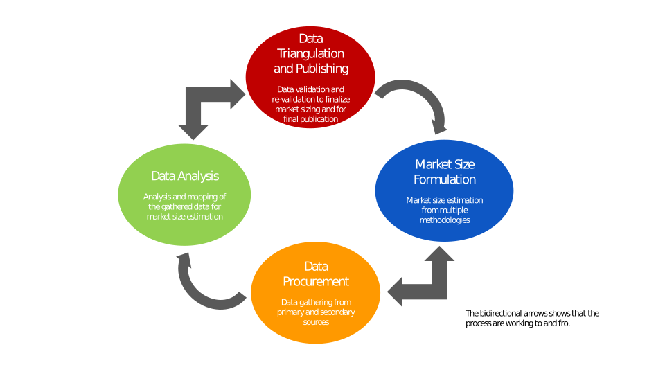
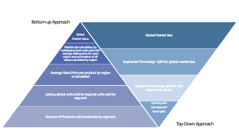
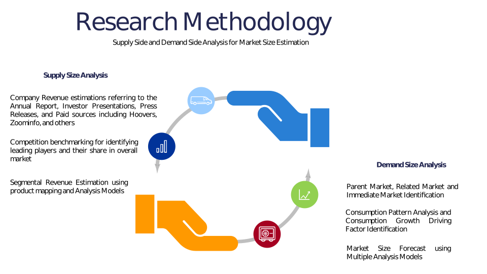
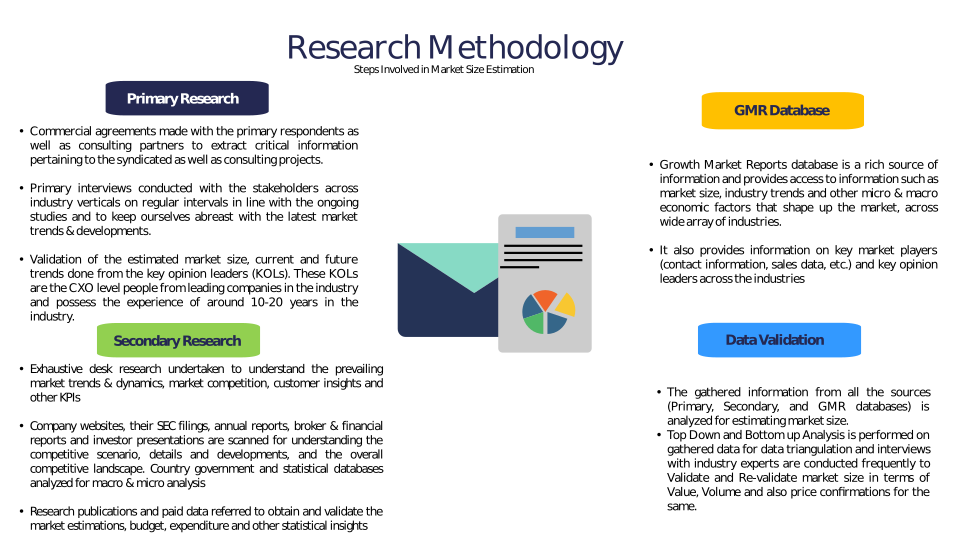
Chapter 3 Research Methodology
Chapter 4 Geo-Spatial Agriculture Analytics Market Overview
4.1 Introduction
4.1.1 Market Taxonomy
4.1.2 Market Definition
4.1.3 Macro-Economic Factors Impacting the Market Growth
4.2 Geo-Spatial Agriculture Analytics Market Dynamics
4.2.1 Market Drivers
4.2.2 Market Restraints
4.2.3 Market Opportunity
4.3 Geo-Spatial Agriculture Analytics Market - Supply Chain Analysis
4.3.1 List of Key Suppliers
4.3.2 List of Key Distributors
4.3.3 List of Key Consumers
4.4 Key Forces Shaping the Geo-Spatial Agriculture Analytics Market
4.4.1 Bargaining Power of Suppliers
4.4.2 Bargaining Power of Buyers
4.4.3 Threat of Substitution
4.4.4 Threat of New Entrants
4.4.5 Competitive Rivalry
4.5 Global Geo-Spatial Agriculture Analytics Market Size & Forecast, 2023-2032
4.5.1 Geo-Spatial Agriculture Analytics Market Size and Y-o-Y Growth
4.5.2 Geo-Spatial Agriculture Analytics Market Absolute $ Opportunity
Chapter 5 Global Geo-Spatial Agriculture Analytics Market Analysis and Forecast By Component
5.1 Introduction
5.1.1 Key Market Trends & Growth Opportunities By Component
5.1.2 Basis Point Share (BPS) Analysis By Component
5.1.3 Absolute $ Opportunity Assessment By Component
5.2 Geo-Spatial Agriculture Analytics Market Size Forecast By Component
5.2.1 Software
5.2.2 Hardware
5.2.3 Services
5.3 Market Attractiveness Analysis By Component
Chapter 6 Global Geo-Spatial Agriculture Analytics Market Analysis and Forecast By Application
6.1 Introduction
6.1.1 Key Market Trends & Growth Opportunities By Application
6.1.2 Basis Point Share (BPS) Analysis By Application
6.1.3 Absolute $ Opportunity Assessment By Application
6.2 Geo-Spatial Agriculture Analytics Market Size Forecast By Application
6.2.1 Crop Monitoring
6.2.2 Soil Analysis
6.2.3 Irrigation Management
6.2.4 Yield Prediction
6.2.5 Field Mapping
6.2.6 Others
6.3 Market Attractiveness Analysis By Application
Chapter 7 Global Geo-Spatial Agriculture Analytics Market Analysis and Forecast By Deployment Mode
7.1 Introduction
7.1.1 Key Market Trends & Growth Opportunities By Deployment Mode
7.1.2 Basis Point Share (BPS) Analysis By Deployment Mode
7.1.3 Absolute $ Opportunity Assessment By Deployment Mode
7.2 Geo-Spatial Agriculture Analytics Market Size Forecast By Deployment Mode
7.2.1 On-Premises
7.2.2 Cloud
7.3 Market Attractiveness Analysis By Deployment Mode
Chapter 8 Global Geo-Spatial Agriculture Analytics Market Analysis and Forecast By Farm Size
8.1 Introduction
8.1.1 Key Market Trends & Growth Opportunities By Farm Size
8.1.2 Basis Point Share (BPS) Analysis By Farm Size
8.1.3 Absolute $ Opportunity Assessment By Farm Size
8.2 Geo-Spatial Agriculture Analytics Market Size Forecast By Farm Size
8.2.1 Small and Medium Farms
8.2.2 Large Farms
8.3 Market Attractiveness Analysis By Farm Size
Chapter 9 Global Geo-Spatial Agriculture Analytics Market Analysis and Forecast By End-User
9.1 Introduction
9.1.1 Key Market Trends & Growth Opportunities By End-User
9.1.2 Basis Point Share (BPS) Analysis By End-User
9.1.3 Absolute $ Opportunity Assessment By End-User
9.2 Geo-Spatial Agriculture Analytics Market Size Forecast By End-User
9.2.1 Agricultural Cooperatives
9.2.2 Agribusinesses
9.2.3 Research Institutes
9.2.4 Government Agencies
9.2.5 Others
9.3 Market Attractiveness Analysis By End-User
Chapter 10 Global Geo-Spatial Agriculture Analytics Market Analysis and Forecast by Region
10.1 Introduction
10.1.1 Key Market Trends & Growth Opportunities By Region
10.1.2 Basis Point Share (BPS) Analysis By Region
10.1.3 Absolute $ Opportunity Assessment By Region
10.2 Geo-Spatial Agriculture Analytics Market Size Forecast By Region
10.2.1 North America
10.2.2 Europe
10.2.3 Asia Pacific
10.2.4 Latin America
10.2.5 Middle East & Africa (MEA)
10.3 Market Attractiveness Analysis By Region
Chapter 11 Coronavirus Disease (COVID-19) Impact
11.1 Introduction
11.2 Current & Future Impact Analysis
11.3 Economic Impact Analysis
11.4 Government Policies
11.5 Investment Scenario
Chapter 12 North America Geo-Spatial Agriculture Analytics Analysis and Forecast
12.1 Introduction
12.2 North America Geo-Spatial Agriculture Analytics Market Size Forecast by Country
12.2.1 U.S.
12.2.2 Canada
12.3 Basis Point Share (BPS) Analysis by Country
12.4 Absolute $ Opportunity Assessment by Country
12.5 Market Attractiveness Analysis by Country
12.6 North America Geo-Spatial Agriculture Analytics Market Size Forecast By Component
12.6.1 Software
12.6.2 Hardware
12.6.3 Services
12.7 Basis Point Share (BPS) Analysis By Component
12.8 Absolute $ Opportunity Assessment By Component
12.9 Market Attractiveness Analysis By Component
12.10 North America Geo-Spatial Agriculture Analytics Market Size Forecast By Application
12.10.1 Crop Monitoring
12.10.2 Soil Analysis
12.10.3 Irrigation Management
12.10.4 Yield Prediction
12.10.5 Field Mapping
12.10.6 Others
12.11 Basis Point Share (BPS) Analysis By Application
12.12 Absolute $ Opportunity Assessment By Application
12.13 Market Attractiveness Analysis By Application
12.14 North America Geo-Spatial Agriculture Analytics Market Size Forecast By Deployment Mode
12.14.1 On-Premises
12.14.2 Cloud
12.15 Basis Point Share (BPS) Analysis By Deployment Mode
12.16 Absolute $ Opportunity Assessment By Deployment Mode
12.17 Market Attractiveness Analysis By Deployment Mode
12.18 North America Geo-Spatial Agriculture Analytics Market Size Forecast By Farm Size
12.18.1 Small and Medium Farms
12.18.2 Large Farms
12.19 Basis Point Share (BPS) Analysis By Farm Size
12.20 Absolute $ Opportunity Assessment By Farm Size
12.21 Market Attractiveness Analysis By Farm Size
12.22 North America Geo-Spatial Agriculture Analytics Market Size Forecast By End-User
12.22.1 Agricultural Cooperatives
12.22.2 Agribusinesses
12.22.3 Research Institutes
12.22.4 Government Agencies
12.22.5 Others
12.23 Basis Point Share (BPS) Analysis By End-User
12.24 Absolute $ Opportunity Assessment By End-User
12.25 Market Attractiveness Analysis By End-User
Chapter 13 Europe Geo-Spatial Agriculture Analytics Analysis and Forecast
13.1 Introduction
13.2 Europe Geo-Spatial Agriculture Analytics Market Size Forecast by Country
13.2.1 Germany
13.2.2 France
13.2.3 Italy
13.2.4 U.K.
13.2.5 Spain
13.2.6 Russia
13.2.7 Rest of Europe
13.3 Basis Point Share (BPS) Analysis by Country
13.4 Absolute $ Opportunity Assessment by Country
13.5 Market Attractiveness Analysis by Country
13.6 Europe Geo-Spatial Agriculture Analytics Market Size Forecast By Component
13.6.1 Software
13.6.2 Hardware
13.6.3 Services
13.7 Basis Point Share (BPS) Analysis By Component
13.8 Absolute $ Opportunity Assessment By Component
13.9 Market Attractiveness Analysis By Component
13.10 Europe Geo-Spatial Agriculture Analytics Market Size Forecast By Application
13.10.1 Crop Monitoring
13.10.2 Soil Analysis
13.10.3 Irrigation Management
13.10.4 Yield Prediction
13.10.5 Field Mapping
13.10.6 Others
13.11 Basis Point Share (BPS) Analysis By Application
13.12 Absolute $ Opportunity Assessment By Application
13.13 Market Attractiveness Analysis By Application
13.14 Europe Geo-Spatial Agriculture Analytics Market Size Forecast By Deployment Mode
13.14.1 On-Premises
13.14.2 Cloud
13.15 Basis Point Share (BPS) Analysis By Deployment Mode
13.16 Absolute $ Opportunity Assessment By Deployment Mode
13.17 Market Attractiveness Analysis By Deployment Mode
13.18 Europe Geo-Spatial Agriculture Analytics Market Size Forecast By Farm Size
13.18.1 Small and Medium Farms
13.18.2 Large Farms
13.19 Basis Point Share (BPS) Analysis By Farm Size
13.20 Absolute $ Opportunity Assessment By Farm Size
13.21 Market Attractiveness Analysis By Farm Size
13.22 Europe Geo-Spatial Agriculture Analytics Market Size Forecast By End-User
13.22.1 Agricultural Cooperatives
13.22.2 Agribusinesses
13.22.3 Research Institutes
13.22.4 Government Agencies
13.22.5 Others
13.23 Basis Point Share (BPS) Analysis By End-User
13.24 Absolute $ Opportunity Assessment By End-User
13.25 Market Attractiveness Analysis By End-User
Chapter 14 Asia Pacific Geo-Spatial Agriculture Analytics Analysis and Forecast
14.1 Introduction
14.2 Asia Pacific Geo-Spatial Agriculture Analytics Market Size Forecast by Country
14.2.1 China
14.2.2 Japan
14.2.3 South Korea
14.2.4 India
14.2.5 Australia
14.2.6 South East Asia (SEA)
14.2.7 Rest of Asia Pacific (APAC)
14.3 Basis Point Share (BPS) Analysis by Country
14.4 Absolute $ Opportunity Assessment by Country
14.5 Market Attractiveness Analysis by Country
14.6 Asia Pacific Geo-Spatial Agriculture Analytics Market Size Forecast By Component
14.6.1 Software
14.6.2 Hardware
14.6.3 Services
14.7 Basis Point Share (BPS) Analysis By Component
14.8 Absolute $ Opportunity Assessment By Component
14.9 Market Attractiveness Analysis By Component
14.10 Asia Pacific Geo-Spatial Agriculture Analytics Market Size Forecast By Application
14.10.1 Crop Monitoring
14.10.2 Soil Analysis
14.10.3 Irrigation Management
14.10.4 Yield Prediction
14.10.5 Field Mapping
14.10.6 Others
14.11 Basis Point Share (BPS) Analysis By Application
14.12 Absolute $ Opportunity Assessment By Application
14.13 Market Attractiveness Analysis By Application
14.14 Asia Pacific Geo-Spatial Agriculture Analytics Market Size Forecast By Deployment Mode
14.14.1 On-Premises
14.14.2 Cloud
14.15 Basis Point Share (BPS) Analysis By Deployment Mode
14.16 Absolute $ Opportunity Assessment By Deployment Mode
14.17 Market Attractiveness Analysis By Deployment Mode
14.18 Asia Pacific Geo-Spatial Agriculture Analytics Market Size Forecast By Farm Size
14.18.1 Small and Medium Farms
14.18.2 Large Farms
14.19 Basis Point Share (BPS) Analysis By Farm Size
14.20 Absolute $ Opportunity Assessment By Farm Size
14.21 Market Attractiveness Analysis By Farm Size
14.22 Asia Pacific Geo-Spatial Agriculture Analytics Market Size Forecast By End-User
14.22.1 Agricultural Cooperatives
14.22.2 Agribusinesses
14.22.3 Research Institutes
14.22.4 Government Agencies
14.22.5 Others
14.23 Basis Point Share (BPS) Analysis By End-User
14.24 Absolute $ Opportunity Assessment By End-User
14.25 Market Attractiveness Analysis By End-User
Chapter 15 Latin America Geo-Spatial Agriculture Analytics Analysis and Forecast
15.1 Introduction
15.2 Latin America Geo-Spatial Agriculture Analytics Market Size Forecast by Country
15.2.1 Brazil
15.2.2 Mexico
15.2.3 Rest of Latin America (LATAM)
15.3 Basis Point Share (BPS) Analysis by Country
15.4 Absolute $ Opportunity Assessment by Country
15.5 Market Attractiveness Analysis by Country
15.6 Latin America Geo-Spatial Agriculture Analytics Market Size Forecast By Component
15.6.1 Software
15.6.2 Hardware
15.6.3 Services
15.7 Basis Point Share (BPS) Analysis By Component
15.8 Absolute $ Opportunity Assessment By Component
15.9 Market Attractiveness Analysis By Component
15.10 Latin America Geo-Spatial Agriculture Analytics Market Size Forecast By Application
15.10.1 Crop Monitoring
15.10.2 Soil Analysis
15.10.3 Irrigation Management
15.10.4 Yield Prediction
15.10.5 Field Mapping
15.10.6 Others
15.11 Basis Point Share (BPS) Analysis By Application
15.12 Absolute $ Opportunity Assessment By Application
15.13 Market Attractiveness Analysis By Application
15.14 Latin America Geo-Spatial Agriculture Analytics Market Size Forecast By Deployment Mode
15.14.1 On-Premises
15.14.2 Cloud
15.15 Basis Point Share (BPS) Analysis By Deployment Mode
15.16 Absolute $ Opportunity Assessment By Deployment Mode
15.17 Market Attractiveness Analysis By Deployment Mode
15.18 Latin America Geo-Spatial Agriculture Analytics Market Size Forecast By Farm Size
15.18.1 Small and Medium Farms
15.18.2 Large Farms
15.19 Basis Point Share (BPS) Analysis By Farm Size
15.20 Absolute $ Opportunity Assessment By Farm Size
15.21 Market Attractiveness Analysis By Farm Size
15.22 Latin America Geo-Spatial Agriculture Analytics Market Size Forecast By End-User
15.22.1 Agricultural Cooperatives
15.22.2 Agribusinesses
15.22.3 Research Institutes
15.22.4 Government Agencies
15.22.5 Others
15.23 Basis Point Share (BPS) Analysis By End-User
15.24 Absolute $ Opportunity Assessment By End-User
15.25 Market Attractiveness Analysis By End-User
Chapter 16 Middle East & Africa (MEA) Geo-Spatial Agriculture Analytics Analysis and Forecast
16.1 Introduction
16.2 Middle East & Africa (MEA) Geo-Spatial Agriculture Analytics Market Size Forecast by Country
16.2.1 Saudi Arabia
16.2.2 South Africa
16.2.3 UAE
16.2.4 Rest of Middle East & Africa (MEA)
16.3 Basis Point Share (BPS) Analysis by Country
16.4 Absolute $ Opportunity Assessment by Country
16.5 Market Attractiveness Analysis by Country
16.6 Middle East & Africa (MEA) Geo-Spatial Agriculture Analytics Market Size Forecast By Component
16.6.1 Software
16.6.2 Hardware
16.6.3 Services
16.7 Basis Point Share (BPS) Analysis By Component
16.8 Absolute $ Opportunity Assessment By Component
16.9 Market Attractiveness Analysis By Component
16.10 Middle East & Africa (MEA) Geo-Spatial Agriculture Analytics Market Size Forecast By Application
16.10.1 Crop Monitoring
16.10.2 Soil Analysis
16.10.3 Irrigation Management
16.10.4 Yield Prediction
16.10.5 Field Mapping
16.10.6 Others
16.11 Basis Point Share (BPS) Analysis By Application
16.12 Absolute $ Opportunity Assessment By Application
16.13 Market Attractiveness Analysis By Application
16.14 Middle East & Africa (MEA) Geo-Spatial Agriculture Analytics Market Size Forecast By Deployment Mode
16.14.1 On-Premises
16.14.2 Cloud
16.15 Basis Point Share (BPS) Analysis By Deployment Mode
16.16 Absolute $ Opportunity Assessment By Deployment Mode
16.17 Market Attractiveness Analysis By Deployment Mode
16.18 Middle East & Africa (MEA) Geo-Spatial Agriculture Analytics Market Size Forecast By Farm Size
16.18.1 Small and Medium Farms
16.18.2 Large Farms
16.19 Basis Point Share (BPS) Analysis By Farm Size
16.20 Absolute $ Opportunity Assessment By Farm Size
16.21 Market Attractiveness Analysis By Farm Size
16.22 Middle East & Africa (MEA) Geo-Spatial Agriculture Analytics Market Size Forecast By End-User
16.22.1 Agricultural Cooperatives
16.22.2 Agribusinesses
16.22.3 Research Institutes
16.22.4 Government Agencies
16.22.5 Others
16.23 Basis Point Share (BPS) Analysis By End-User
16.24 Absolute $ Opportunity Assessment By End-User
16.25 Market Attractiveness Analysis By End-User
Chapter 17 Competition Landscape
17.1 Geo-Spatial Agriculture Analytics Market: Competitive Dashboard
17.2 Global Geo-Spatial Agriculture Analytics Market: Market Share Analysis, 2023
17.3 Company Profiles (Details – Overview, Financials, Developments, Strategy)
17.3.1 Trimble Inc.
17.3.2 Deere & Company (John Deere)
17.3.3 Ag Leader Technology
17.3.4 Climate LLC (A subsidiary of Bayer AG)
17.3.5 Topcon Positioning Systems
17.3.6 Planet Labs PBC
17.3.7 CropX Technologies
17.3.8 AgEagle Aerial Systems
17.3.9 Sentera
17.3.10 Farmers Edge
17.3.11 Esri
17.3.12 SatSure Analytics
17.3.13 OneSoil
17.3.14 Granular (A Corteva Agriscience Company)
17.3.15 Taranis (A Bayer Digital Farming Brand)
17.3.16 Geosys (A Telespazio Company)
17.3.17 Hexagon AB
17.3.18 PrecisionHawk
Methodology
Related Reports
Some other reports from this category!




Our Clients