Drone-Mounted GPR Antenna Market Size, Share & Growth Analysis, 2026-2034
Drone-Mounted GPR Antenna Market Size, Share & Growth Analysis, 2026-2034
Segments - by Product Type (Single Frequency Antenna, Multi-Frequency Antenna), by Application (Geological Survey, Utility Detection, Archaeology, Environmental Assessment, Infrastructure Inspection, Others), by End-User (Construction, Oil & Gas, Mining, Agriculture, Environmental Monitoring, Others), by Frequency Range (Low Frequency, Medium Frequency, High Frequency)



Last Updated : Jun, 2026
| Report ID :AD-9248
| 4.4 Rating
| 50 Reviews
| 267 Pages
| Format :


Drone-Mounted GPR Antenna Market: Key Numbers
The Drone-Mounted GPR Antenna market was valued at USD 242 Million in 2025 and is projected to reach USD 789 Million by 2034, a CAGR of 14.2%.
| Market size (2025) | USD 242 Million |
|---|---|
| Forecast (2034) | USD 789 Million |
| CAGR (2026-2034) | 14.2% |
| Largest region | North America (USD 86 Million) |
| Segments covered | Product Type, Application, End-User, Frequency Range |
| Key companies | IDS GeoRadar (Hexagon), GSSI (Geophysical Survey Systems, Inc.), Sensors & Software Inc., ImpulseRadar, MALA GPR (Guideline Geo) |
This report is updated with the latest market data and insights as of June 2026. Base year: 2025 | Forecast period: 2026-2034
Drone-Mounted GPR Antenna Market Size and Growth Outlook
Our analysis shows that the global drone-mounted GPR antenna market size reached USD 242 million in 2025, with robust year-on-year momentum driven by technological advancements and expanding applications in subsurface exploration. The market is expected to grow at a CAGR of 14.2% from 2026 to 2034, reaching a projected value of USD 789 million by 2034. This remarkable expansion is primarily fueled by increasing demand for efficient, non-invasive ground-penetrating radar (GPR) solutions across industries such as construction, mining, agriculture, and environmental monitoring, coupled with the accelerating adoption of drone technologies for surveys in remote and challenging terrain. The convergence of drone platforms with advanced sensor payloads, including compact drone-based radar systems, is reshaping how subsurface data is collected and interpreted at scale.

The rising emphasis on infrastructure development and maintenance is a significant growth factor for the drone-mounted GPR antenna market. As nations invest in upgrading transportation, utility, and communication networks, there is a heightened need for accurate subsurface mapping to avoid costly damages and ensure safety during construction. Drone-mounted GPR antennas offer a transformative solution, enabling rapid, high-resolution surveys over large and inaccessible areas without disrupting ongoing operations. The integration of advanced data analytics, real-time imaging, and automated flight planning further enhances the value proposition of these systems, attracting widespread adoption among civil engineers, geologists, and utility companies. This trend is expected to intensify as urbanization accelerates and the demand for reliable infrastructure assessment grows globally throughout the 2026-2034 forecast period.
Another key driver is the increasing focus on environmental sustainability and resource management. Governments and private organizations are leveraging drone-mounted GPR antennas for applications such as groundwater mapping, contamination assessment, and archaeological site preservation. The ability to obtain detailed subsurface data without disturbing the environment is particularly valuable in sensitive ecological zones and heritage sites. Additionally, the mining and oil and gas sectors are utilizing these technologies for mineral exploration and pipeline inspections, reducing operational risks and environmental impact. As regulatory frameworks tighten regarding environmental protection, the adoption of drone-mounted GPR solutions is poised to expand further, propelling market growth well into the next decade.
Technological advancements are playing a pivotal role in shaping the market landscape. Innovations in antenna design, frequency modulation, and signal processing have significantly improved depth penetration, resolution, and accuracy. The emergence of multi-frequency antennas and AI-driven data interpretation tools is enabling users to address a wider range of applications with a single platform. Moreover, the miniaturization of components and enhanced battery technology are making drones more capable of carrying sophisticated GPR payloads over longer distances. These breakthroughs are lowering barriers to entry for new market participants and fostering a competitive landscape that encourages continuous innovation. Related sensing technologies, including airborne magnetometer arrays, are increasingly being bundled with GPR payloads to provide comprehensive multi-physics survey outputs.
From a regional perspective, North America currently dominates the drone-mounted GPR antenna market, accounting for approximately 35.5% of global revenue in 2025, followed by Europe at 26.0% and Asia Pacific at 22.5%. The strong presence of leading technology providers, substantial infrastructure investments, and favorable regulatory environments contribute to North America's leadership. However, the Asia Pacific region is anticipated to witness the fastest growth during the forecast period, driven by rapid urbanization, industrialization, and increasing awareness of the benefits of drone-based GPR solutions. Latin America and the Middle East and Africa are also emerging as promising markets, supported by growing investments in mining, oil and gas exploration, and environmental monitoring initiatives.
Drone-Mounted GPR Antenna Market by Product Type
The drone-mounted GPR antenna market by product type is segmented into single frequency antennas and multi-frequency antennas. Single frequency antennas are widely used for applications requiring deep penetration but moderate resolution, such as geological surveys and mineral exploration. These antennas are favored for their simplicity, cost-effectiveness, and reliability in detecting large subsurface anomalies. Adoption of single frequency antennas remains strong in regions with extensive mining and oil and gas activities, where the primary objective is to identify broad geological features. However, their limited ability to resolve complex stratigraphy and shallow targets has prompted users to explore more advanced solutions. Single frequency antennas accounted for approximately 42.5% of market revenue in 2025.

Multi-frequency antennas have gained significant traction, now representing approximately 57.5% of market revenue in 2025, driven by their versatility and superior performance. By operating across a range of frequencies, these antennas can simultaneously achieve high-resolution imaging of shallow subsurface features and adequate depth penetration for detecting buried objects at greater depths. This capability makes them ideal for diverse applications, including utility detection, infrastructure inspection, archaeology, and environmental assessment. Demand for multi-frequency GPR antennas is particularly high in urban environments, where the subsurface is congested with utilities, pipelines, and historical artifacts. Operators working with UAV antenna platforms increasingly prefer multi-frequency GPR payloads for their ability to serve multiple project types with a single hardware configuration.
Ongoing advancements in antenna technology are blurring the lines between single and multi-frequency systems. Manufacturers are focusing on developing hybrid solutions that combine the best attributes of both product types, providing users with customizable platforms tailored to specific project requirements. Integration of lightweight materials and modular designs is enabling drones to carry more sophisticated antenna payloads without compromising flight performance or operational efficiency. The competitive landscape within the product type segment is characterized by intense research and development efforts, strategic collaborations, and frequent product launches aimed at capturing a share of the rapidly expanding addressable market.
Leading players are investing heavily in enhancing sensitivity, bandwidth, and signal processing capabilities to cater to evolving end-user needs. The emergence of open-source hardware and software platforms is also fostering innovation by allowing smaller companies and research institutions to participate. As the technology matures and becomes more accessible, adoption of both single and multi-frequency drone-mounted GPR antennas is expected to accelerate, with multi-frequency systems maintaining their dominant share through the 2026-2034 forecast period.
Drone-Mounted GPR Antenna Market Report Scope
| Attributes | Details |
| Report Title | Drone-Mounted GPR Antenna Market Research Report 2034 |
| By Product Type | Single Frequency Antenna, Multi-Frequency Antenna |
| By Application | Geological Survey, Utility Detection, Archaeology, Environmental Assessment, Infrastructure Inspection, Others |
| By End-User | Construction, Oil & Gas, Mining, Agriculture, Environmental Monitoring, Others |
| By Frequency Range | Low Frequency, Medium Frequency, High Frequency |
| Regions Covered | North America, Europe, APAC, Latin America, MEA |
| Base Year | 2025 |
| Historic Data | 2019-2024 |
| Forecast Period | 2026-2034 |
| Number of Pages | 267 |
| Number of Tables & Figures | 356 |
| Customization Available | Yes, the report can be customized as per your need. |
Drone-Mounted GPR Antenna Market by Application
The application segment of the drone-mounted GPR antenna market encompasses geological survey, utility detection, archaeology, environmental assessment, infrastructure inspection, and others. Geological surveys represent a significant share of the market, as drone-mounted GPR systems are extensively used to map subsurface structures, identify mineral deposits, and assess ground stability. These applications are critical for mining, oil and gas exploration, and civil engineering projects, where accurate geological data is essential for decision-making and risk mitigation. The ability to conduct rapid, large-scale surveys in remote and challenging terrains without physical intrusion is a key advantage driving adoption in this segment throughout the 2026-2034 forecast period.
Utility detection is a major application area, particularly in urban and industrial settings where the risk of damaging underground utilities during construction or maintenance activities is high. Drone-mounted GPR antennas enable precise mapping of buried pipelines, cables, and conduits, reducing the likelihood of costly accidents and service disruptions. The growing emphasis on smart city development and the need for reliable utility infrastructure are fueling demand for advanced GPR solutions. Regulatory mandates requiring accurate utility location data prior to excavation activities are further boosting adoption of drone-based GPR systems in this segment. As urban infrastructure ages and cities expand, utility detection is expected to remain one of the highest-value application categories through 2034.
Archaeology and environmental assessment are emerging as high-growth application areas. In archaeology, drone-mounted GPR systems allow researchers to non-invasively explore historical sites, detect buried artifacts, and map ancient structures with unprecedented accuracy. The ability to cover large areas quickly and generate detailed subsurface images is revolutionizing the field, making it possible to uncover new insights while preserving site integrity. In environmental assessment, these antennas are used to monitor groundwater levels, identify contamination plumes, and assess soil conditions. These applications are becoming increasingly important as concerns over environmental sustainability and resource management intensify globally, supported by tightening regulatory requirements in North America, Europe, and parts of Asia Pacific.
Infrastructure inspection is a critical application driving market growth. The aging of infrastructure assets such as roads, bridges, dams, and tunnels is a global challenge, necessitating regular inspections to ensure safety and longevity. Drone-mounted GPR systems provide a cost-effective and efficient means of detecting subsurface defects, voids, and deterioration without disrupting normal operations. The integration of GPR data with other sensor modalities, such as LiDAR and photogrammetry, is enabling comprehensive asset management and predictive maintenance strategies. As governments and private operators prioritize infrastructure resilience in the post-2025 investment cycle, demand for drone-based GPR inspection solutions is expected to surge across both developed and developing economies.
Drone-Mounted GPR Antenna Market by End-User
The end-user segment of the drone-mounted GPR antenna market includes construction, oil and gas, mining, agriculture, environmental monitoring, and others. The construction industry is one of the largest consumers, leveraging drone-mounted GPR antennas for site assessment, utility detection, and quality control. Accurate subsurface data obtained before and during construction activities helps prevent costly delays, rework, and safety incidents. Construction companies are increasingly integrating drone-mounted GPR solutions into their standard workflows to enhance project efficiency, reduce risks, and comply with evolving regulatory requirements related to underground utility protection and structural safety.
The oil and gas sector represents another significant end-user, utilizing drone-mounted GPR antennas for pipeline inspection, leak detection, and reservoir characterization. Harsh and often remote operating environments make traditional survey methods challenging and expensive. Drones equipped with advanced GPR antennas offer a safer, faster, and more cost-effective alternative, enabling operators to monitor asset integrity and identify potential issues before they escalate. The growing focus on operational efficiency, environmental protection, and regulatory compliance is driving adoption of drone-mounted GPR solutions across upstream, midstream, and downstream oil and gas operations. This trend is expected to remain robust as global energy infrastructure investment continues through 2034.
Mining companies are major end-users, employing drone-mounted GPR antennas for mineral exploration, ore body delineation, and ground stability assessment. The ability to rapidly survey large and inaccessible areas, coupled with high-resolution imaging capabilities, is transforming exploration and extraction processes. Drones are particularly valuable in open-pit and underground mining operations, where safety and efficiency are paramount. As demand for critical minerals including lithium, cobalt, and rare earth elements accelerates globally, driven by the energy transition, the mining sector is expected to remain a key growth driver for the drone-mounted GPR antenna market throughout the forecast period.
Agriculture and environmental monitoring are emerging as promising end-user segments, driven by the need for sustainable resource management and precision farming. Drone-mounted GPR antennas are being used to map soil moisture, detect subsurface obstacles, and monitor groundwater levels, enabling farmers and environmental agencies to make informed decisions. The adoption of these technologies is expected to accelerate as awareness of their benefits grows and the cost of drone-based solutions continues to decrease. Other end-users, including research institutions, government agencies, and disaster response teams, are also exploring the potential of drone-mounted GPR antennas for a wide range of applications, contributing to market diversification and sustained growth.
Drone-Mounted GPR Antenna Market by Frequency Range
The frequency range segment of the drone-mounted GPR antenna market is categorized into low frequency, medium frequency, and high frequency. Low-frequency antennas are typically used for applications requiring deep penetration, such as geological surveys, mineral exploration, and groundwater mapping. These antennas are capable of detecting large subsurface features at depths of several meters, making them ideal for projects where depth is more critical than resolution. However, the lower resolution of low-frequency antennas limits their effectiveness in applications requiring detailed imaging of shallow targets or small objects. Despite this limitation, low-frequency systems maintain a solid user base in the mining and oil and gas sectors.
Medium-frequency antennas offer a balance between depth penetration and resolution, making them suitable for a wide range of applications, including utility detection, infrastructure inspection, and environmental assessment. These antennas can provide detailed images of subsurface features at intermediate depths, enabling users to identify both large and small anomalies with confidence. The versatility of medium-frequency antennas has made them the preferred choice for many end-users, particularly in urban environments where the subsurface is complex and congested. The growing demand for multi-purpose GPR solutions is expected to drive continued adoption of medium-frequency antennas through the 2026-2034 forecast period, reinforcing their position as the most broadly applied frequency category.
High-frequency antennas are designed for applications requiring high-resolution imaging of shallow subsurface features, such as archaeology, forensic investigations, and quality control in construction. These antennas are capable of detecting small objects and fine stratigraphy at depths of up to a few meters. The ability to generate detailed images of near-surface features is particularly valuable where precision is paramount. However, the limited depth penetration of high-frequency antennas restricts their use to specific applications. The ongoing development of advanced signal processing algorithms and multi-frequency platforms is helping to mitigate these limitations, expanding the potential use cases for high-frequency GPR antennas. Manufacturers are also developing broadband antenna systems capable of spanning low, medium, and high frequency ranges within a single drone payload, further eroding historical boundaries between frequency categories.
The choice of frequency range is a critical consideration for end-users, as it directly impacts the performance and suitability of the GPR system for specific applications. Manufacturers are increasingly offering customizable platforms that allow users to select or switch between different frequency ranges based on project requirements, enhancing the commercial appeal of drone-mounted GPR solutions across all frequency segments.
Drone-Mounted GPR Antenna Market Opportunities and Threats
The drone-mounted GPR antenna market is rich with opportunities as industries continue to seek innovative solutions for subsurface exploration and asset management. One of the most promising opportunities lies in the integration of artificial intelligence and machine learning algorithms with GPR data analysis. By automating the interpretation of complex subsurface images, AI-powered platforms can significantly enhance the accuracy, speed, and consistency of survey results. This capability is especially valuable in large-scale projects where manual data processing would be time-consuming and prone to human error. The growing availability of cloud-based analytics platforms is enabling real-time collaboration and decision-making, further amplifying the value proposition of drone-mounted GPR solutions as we move through the 2026-2034 forecast window.
Another major opportunity is the expansion into emerging economies and new application areas. As the cost of drone technology continues to decline and regulatory frameworks become more supportive, small and medium-sized enterprises in agriculture, environmental monitoring, and disaster response are gaining access to advanced GPR solutions. The development of lightweight, modular, and user-friendly systems is making it easier for non-experts to deploy and benefit from drone-mounted GPR technology. Additionally, the increasing frequency and severity of natural disasters, such as floods and earthquakes, are creating new demand for rapid and accurate subsurface assessment tools to support emergency response and recovery efforts. The broader remote sensing ecosystem, including markets for complementary technologies, is converging to create integrated multi-sensor platforms that command higher per-project value.
Despite the numerous opportunities, the drone-mounted GPR antenna market faces several restraining factors. One of the primary challenges is the complexity of data interpretation and the need for specialized expertise to analyze GPR survey results. While advancements in automation and AI are helping to address this issue, the lack of standardized data formats and interoperability between different systems remains a barrier to widespread adoption. Additionally, regulatory restrictions on drone operations, particularly in densely populated or sensitive areas, can limit the deployment of drone-mounted GPR systems. Concerns over data privacy, airspace safety, and environmental impact also need to be carefully managed. Competition from alternative non-destructive testing and subsurface imaging technologies, as well as potential supply chain disruptions in key electronic components, represent additional headwinds that market participants must navigate.
Drone-Mounted GPR Antenna Market Size by Region
North America leads the global drone-mounted GPR antenna market, accounting for approximately USD 86 million in revenue in 2025, driven by substantial investments in infrastructure, advanced technological capabilities, and a favorable regulatory environment. The region's dominance is reinforced by the presence of leading technology providers, well-funded research institutions, and a highly skilled workforce. The United States and Canada are at the forefront of adopting drone-mounted GPR solutions for applications ranging from utility detection and infrastructure inspection to environmental monitoring and disaster response. The market in North America is projected to maintain a healthy growth trajectory, supported by ongoing infrastructure modernization initiatives under federal and state-level investment programs and increasing awareness of the benefits of drone-based subsurface exploration through 2034.

Europe is the second-largest market for drone-mounted GPR antennas, with a market size of approximately USD 63 million in 2025. The region is characterized by a strong focus on environmental sustainability, heritage preservation, and urban development. Countries such as Germany, the United Kingdom, France, and the Nordic nations are leading adopters of drone-mounted GPR technology, leveraging it for archaeological surveys, environmental assessments, and utility mapping. The European market is expected to grow at a CAGR of approximately 13.8% from 2026 to 2034, driven by increasing investments in smart city projects, stringent regulatory standards related to subsurface utility engineering, and the growing need for efficient infrastructure maintenance solutions.
The Asia Pacific region is emerging as the fastest-growing market for drone-mounted GPR antennas, with a market size of approximately USD 54 million in 2025. Rapid urbanization, industrialization, and infrastructure development in China, India, Japan, South Korea, and Southeast Asia are fueling demand for advanced subsurface exploration technologies. The region's vast and diverse landscapes, combined with the increasing frequency of natural disasters, are also creating new opportunities for drone-mounted GPR applications in environmental monitoring and disaster management. The Asia Pacific market is expected to outpace all other regions in growth rate through 2034, supported by rising investments in research and development, expanding industrial activities, and strong government initiatives to promote technology-driven infrastructure management. Latin America and the Middle East and Africa, representing approximately 9.0% and 7.0% of global revenue respectively in 2025, are expected to see growing adoption driven by mining investment, energy sector expansion, and increasing environmental regulatory activity.
Drone-Mounted GPR Antenna Market Competitive Landscape
The competitive landscape of the drone-mounted GPR antenna market is characterized by the presence of both established players and innovative startups, each striving to gain a foothold in this rapidly evolving industry. Leading companies are focusing on technological innovation, strategic partnerships, and product differentiation to maintain their competitive edge. The market is witnessing a steady influx of new entrants, attracted by the growing demand for advanced subsurface exploration solutions and the relatively low barriers to entry in terms of hardware development. This dynamic environment is fostering a culture of continuous innovation, with companies investing heavily in research and development to enhance the performance, reliability, and usability of their products.
Strategic collaborations and joint ventures are becoming increasingly common, as companies seek to leverage complementary strengths and expand their market reach. Partnerships between drone manufacturers, GPR technology providers, and software developers are enabling the creation of integrated solutions that offer end-users a seamless and comprehensive experience. These collaborations are also facilitating the development of industry standards and best practices, which are essential for ensuring interoperability and data consistency across different platforms. As the market matures, consolidation is expected to increase, with larger players acquiring smaller firms to strengthen their product portfolios and expand into new geographic markets. The parallel growth of adjacent sensing markets, such as those for drone-based magnetometers, is accelerating multi-sensor integration strategies among major vendors.
The competitive landscape is also shaped by the growing importance of software and data analytics. Companies that can offer advanced data processing, visualization, and interpretation tools are gaining a significant advantage, as end-users increasingly demand actionable insights rather than raw data. The integration of cloud-based analytics, artificial intelligence, and machine learning is enabling real-time data analysis and remote collaboration, further enhancing the value proposition of drone-mounted GPR solutions. As competition intensifies, companies are differentiating themselves through customer support, training, and value-added services, in addition to hardware and firmware innovation.
Some of the major companies operating in the drone-mounted GPR antenna market include IDS GeoRadar (Hexagon), Sensors & Software Inc., GSSI (Geophysical Survey Systems, Inc.), ImpulseRadar, MALA GPR (Guideline Geo), SPH Engineering, 3D-Radar AS, Terra Drone Corporation, and Proceq (Screening Eagle Technologies). IDS GeoRadar, a Hexagon subsidiary, is renowned for its advanced multi-frequency GPR solutions and integrated drone platforms, catering to a wide range of applications from infrastructure inspection to environmental monitoring. Sensors & Software Inc. is a leading provider of GPR systems known for their reliability, ease of use, and robust data analysis capabilities. GSSI offers a comprehensive portfolio of GPR antennas and software solutions, with a strong focus on utility detection, archaeology, and geological surveys.
ImpulseRadar and 3D-Radar AS are recognized for innovative antenna designs and signal processing technologies that enable high-resolution imaging and deep penetration capabilities. MALA GPR, part of Guideline Geo, is a global leader in GPR technology offering a wide range of products for construction, mining, and environmental assessment applications. SPH Engineering specializes in drone flight management and integration solutions that enable seamless deployment of GPR and other sensor payloads. Geoscanners AB and Inkonova AB are notable for their specialized contributions to aerial GPR system design and underground robotic survey platforms respectively. Terra Drone Corporation brings strong UAV integration and operational expertise to the market across multiple regions. These companies are continuously investing in research and development to introduce new products and features that address the evolving needs of the market, while a growing number of startups and niche providers are entering the space to bring fresh perspectives and innovative solutions.
Overall, the competitive outlook for the drone-mounted GPR antenna market is highly dynamic, with companies competing on the basis of technology, performance, price, and customer service. The market is expected to witness further consolidation and specialization as it matures, with leading players expanding their global footprint and enhancing their product offerings to capture new growth opportunities. As end-user requirements become more sophisticated and diverse, the ability to deliver integrated, user-friendly, and cost-effective solutions will be the key determinant of sustained commercial success in this rapidly growing market through 2034.
Top Companies in the Drone-Mounted GPR Antenna Market
- IDS GeoRadar (Hexagon)
- GSSI (Geophysical Survey Systems, Inc.)
- Sensors & Software Inc.
- ImpulseRadar
- MALA GPR (Guideline Geo)
- SPH Engineering
- Geoscanners AB
- 3D-Radar AS
- Terra Drone Corporation
- DJI Enterprise
- Leica Geosystems (Hexagon)
- RIEGL Laser Measurement Systems
- Geometrics, Inc.
- Inkonova AB
- Proceq (Screening Eagle Technologies)
Segments
The Drone-Mounted GPR Antenna market has been segmented on the basis of
Product Type
- Single Frequency Antenna
- Multi-Frequency Antenna
Application
- Geological Survey
- Utility Detection
- Archaeology
- Environmental Assessment
- Infrastructure Inspection
- Others
End-User
- Construction
- Oil & Gas
- Mining
- Agriculture
- Environmental Monitoring
- Others
Frequency Range
- Low Frequency
- Medium Frequency
- High Frequency
Frequently Asked Questions
Yes, the report can be fully customized to meet specific research requirements. Customization options include additional country-level or sub-regional analysis, deeper profiling of selected companies, expanded coverage of specific application verticals or end-user industries, custom forecast periods, and additional segmentation by frequency range or drone platform type. Please contact our research team to discuss tailored solutions that fit your strategic and commercial needs.
Leading companies in the drone-mounted GPR antenna market as of 2025 include IDS GeoRadar (Hexagon), GSSI (Geophysical Survey Systems, Inc.), Sensors & Software Inc., ImpulseRadar, MALA GPR (Guideline Geo), SPH Engineering, Geoscanners AB, 3D-Radar AS, Terra Drone Corporation, DJI Enterprise, Leica Geosystems (Hexagon), RIEGL Laser Measurement Systems, Geometrics Inc., Inkonova AB, and Proceq (Screening Eagle Technologies). These firms compete on antenna performance, software analytics capabilities, system integration, and global service networks.
Major opportunities include the integration of machine learning for automated anomaly detection, expansion into emerging economies as drone costs fall, and growing demand from disaster response agencies and smart city programs. Complementary markets such as drone magnetometers and related remote sensing tools are converging with GPR to create multi-sensor survey suites, opening new revenue streams. Key challenges include the shortage of trained GPR data interpretation specialists, regulatory restrictions on drone flight in urban and sensitive airspace, lack of standardized data formats across platforms, and concerns about data privacy and airspace safety.
Low-frequency antennas (typically below 200 MHz) provide deep penetration of several meters, making them suitable for geological surveys, groundwater mapping, and mineral exploration. Medium-frequency antennas (200 MHz to 1 GHz) balance depth and resolution, serving utility detection, environmental assessment, and infrastructure inspection. High-frequency antennas (above 1 GHz) deliver fine near-surface resolution for archaeology, forensic investigations, and construction quality control. Manufacturers increasingly offer switchable or broadband platforms that span multiple frequency ranges within a single payload system.
Key technological drivers include AI-powered data interpretation that automates complex subsurface image analysis, broadband and multi-frequency antenna designs that extend application versatility, and lightweight composite materials that improve drone payload capacity and flight endurance. Integration with complementary sensor modalities such as drone-mounted 3D scanning and LiDAR is enabling comprehensive multi-sensor survey platforms. Cloud-based real-time analytics and improved signal processing algorithms are also substantially raising the accuracy and usability of drone-mounted GPR systems.
North America leads the global market with roughly 35.5% revenue share in 2025, supported by advanced regulatory frameworks, strong infrastructure investment, and a dense base of technology providers. Europe follows with approximately 26.0% share, driven by heritage preservation programs and smart city initiatives. Asia Pacific, holding about 22.5% share, is the fastest-growing region through 2034 due to rapid urbanization and expanding industrial activity in China, India, Japan, and Southeast Asia.
7. What are the differences between single frequency and multi-frequency drone-mounted GPR antennas?
Single frequency antennas operate at a fixed frequency, offering deep penetration suited to geological surveys and broad subsurface anomaly detection, but with limited resolution for shallow or complex targets. Multi-frequency antennas operate across multiple frequency bands simultaneously or sequentially, delivering both high-resolution shallow imaging and adequate depth penetration. Multi-frequency systems held approximately 57.5% of the market in 2025 and are preferred for utility detection, infrastructure inspection, and urban archaeology where subsurface conditions are complex.
The construction sector is the largest end-user of drone-mounted GPR antennas, relying on these systems for site assessment, utility mapping, and quality control. Oil and gas companies use them for pipeline inspection and reservoir characterization, while mining firms deploy them for mineral exploration and ground stability analysis. Agriculture and environmental monitoring are rapidly emerging end-user segments, leveraging GPR data for soil moisture mapping, groundwater monitoring, and contamination detection.
The primary applications of drone-mounted GPR antennas include geological survey, utility detection, archaeology, environmental assessment, infrastructure inspection, and several emerging uses such as disaster response and precision agriculture. Infrastructure inspection and utility detection together represent the largest application revenue pool as of 2025, while archaeology and environmental assessment are the fastest-growing segments due to rising demand for non-invasive, large-area scanning solutions.
The global drone-mounted GPR antenna market reached USD 242 million in 2025 and is projected to grow at a CAGR of 14.2% from 2026 to 2034, reaching approximately USD 789 million by 2034. This growth is driven by rising demand for non-invasive subsurface exploration, increased infrastructure spending, and rapid advances in drone and antenna technology across construction, mining, oil and gas, and environmental sectors.
Table Of Content
Chapter 1 Executive SummaryChapter 2 Assumptions and Acronyms Used
Chapter 3 Research Methodology
Chapter 4 Drone-Mounted GPR Antenna Market Overview
4.1 Introduction
4.1.1 Market Taxonomy
4.1.2 Market Definition
4.1.3 Macro-Economic Factors Impacting the Market Growth
4.2 Drone-Mounted GPR Antenna Market Dynamics
4.2.1 Market Drivers
4.2.2 Market Restraints
4.2.3 Market Opportunity
4.3 Drone-Mounted GPR Antenna Market - Supply Chain Analysis
4.3.1 List of Key Suppliers
4.3.2 List of Key Distributors
4.3.3 List of Key Consumers
4.4 Key Forces Shaping the Drone-Mounted GPR Antenna Market
4.4.1 Bargaining Power of Suppliers
4.4.2 Bargaining Power of Buyers
4.4.3 Threat of Substitution
4.4.4 Threat of New Entrants
4.4.5 Competitive Rivalry
4.5 Global Drone-Mounted GPR Antenna Market Size & Forecast, 2023-2032
4.5.1 Drone-Mounted GPR Antenna Market Size and Y-o-Y Growth
4.5.2 Drone-Mounted GPR Antenna Market Absolute $ Opportunity
Chapter 5 Global Drone-Mounted GPR Antenna Market Analysis and Forecast By Product Type
5.1 Introduction
5.1.1 Key Market Trends & Growth Opportunities By Product Type
5.1.2 Basis Point Share (BPS) Analysis By Product Type
5.1.3 Absolute $ Opportunity Assessment By Product Type
5.2 Drone-Mounted GPR Antenna Market Size Forecast By Product Type
5.2.1 Single Frequency Antenna
5.2.2 Multi-Frequency Antenna
5.3 Market Attractiveness Analysis By Product Type
Chapter 6 Global Drone-Mounted GPR Antenna Market Analysis and Forecast By Application
6.1 Introduction
6.1.1 Key Market Trends & Growth Opportunities By Application
6.1.2 Basis Point Share (BPS) Analysis By Application
6.1.3 Absolute $ Opportunity Assessment By Application
6.2 Drone-Mounted GPR Antenna Market Size Forecast By Application
6.2.1 Geological Survey
6.2.2 Utility Detection
6.2.3 Archaeology
6.2.4 Environmental Assessment
6.2.5 Infrastructure Inspection
6.2.6 Others
6.3 Market Attractiveness Analysis By Application
Chapter 7 Global Drone-Mounted GPR Antenna Market Analysis and Forecast By End-User
7.1 Introduction
7.1.1 Key Market Trends & Growth Opportunities By End-User
7.1.2 Basis Point Share (BPS) Analysis By End-User
7.1.3 Absolute $ Opportunity Assessment By End-User
7.2 Drone-Mounted GPR Antenna Market Size Forecast By End-User
7.2.1 Construction
7.2.2 Oil & Gas
7.2.3 Mining
7.2.4 Agriculture
7.2.5 Environmental Monitoring
7.2.6 Others
7.3 Market Attractiveness Analysis By End-User
Chapter 8 Global Drone-Mounted GPR Antenna Market Analysis and Forecast By Frequency Range
8.1 Introduction
8.1.1 Key Market Trends & Growth Opportunities By Frequency Range
8.1.2 Basis Point Share (BPS) Analysis By Frequency Range
8.1.3 Absolute $ Opportunity Assessment By Frequency Range
8.2 Drone-Mounted GPR Antenna Market Size Forecast By Frequency Range
8.2.1 Low Frequency
8.2.2 Medium Frequency
8.2.3 High Frequency
8.3 Market Attractiveness Analysis By Frequency Range
Chapter 9 Global Drone-Mounted GPR Antenna Market Analysis and Forecast by Region
9.1 Introduction
9.1.1 Key Market Trends & Growth Opportunities By Region
9.1.2 Basis Point Share (BPS) Analysis By Region
9.1.3 Absolute $ Opportunity Assessment By Region
9.2 Drone-Mounted GPR Antenna Market Size Forecast By Region
9.2.1 North America
9.2.2 Europe
9.2.3 Asia Pacific
9.2.4 Latin America
9.2.5 Middle East & Africa (MEA)
9.3 Market Attractiveness Analysis By Region
Chapter 10 Coronavirus Disease (COVID-19) Impact
10.1 Introduction
10.2 Current & Future Impact Analysis
10.3 Economic Impact Analysis
10.4 Government Policies
10.5 Investment Scenario
Chapter 11 North America Drone-Mounted GPR Antenna Analysis and Forecast
11.1 Introduction
11.2 North America Drone-Mounted GPR Antenna Market Size Forecast by Country
11.2.1 U.S.
11.2.2 Canada
11.3 Basis Point Share (BPS) Analysis by Country
11.4 Absolute $ Opportunity Assessment by Country
11.5 Market Attractiveness Analysis by Country
11.6 North America Drone-Mounted GPR Antenna Market Size Forecast By Product Type
11.6.1 Single Frequency Antenna
11.6.2 Multi-Frequency Antenna
11.7 Basis Point Share (BPS) Analysis By Product Type
11.8 Absolute $ Opportunity Assessment By Product Type
11.9 Market Attractiveness Analysis By Product Type
11.10 North America Drone-Mounted GPR Antenna Market Size Forecast By Application
11.10.1 Geological Survey
11.10.2 Utility Detection
11.10.3 Archaeology
11.10.4 Environmental Assessment
11.10.5 Infrastructure Inspection
11.10.6 Others
11.11 Basis Point Share (BPS) Analysis By Application
11.12 Absolute $ Opportunity Assessment By Application
11.13 Market Attractiveness Analysis By Application
11.14 North America Drone-Mounted GPR Antenna Market Size Forecast By End-User
11.14.1 Construction
11.14.2 Oil & Gas
11.14.3 Mining
11.14.4 Agriculture
11.14.5 Environmental Monitoring
11.14.6 Others
11.15 Basis Point Share (BPS) Analysis By End-User
11.16 Absolute $ Opportunity Assessment By End-User
11.17 Market Attractiveness Analysis By End-User
11.18 North America Drone-Mounted GPR Antenna Market Size Forecast By Frequency Range
11.18.1 Low Frequency
11.18.2 Medium Frequency
11.18.3 High Frequency
11.19 Basis Point Share (BPS) Analysis By Frequency Range
11.20 Absolute $ Opportunity Assessment By Frequency Range
11.21 Market Attractiveness Analysis By Frequency Range
Chapter 12 Europe Drone-Mounted GPR Antenna Analysis and Forecast
12.1 Introduction
12.2 Europe Drone-Mounted GPR Antenna Market Size Forecast by Country
12.2.1 Germany
12.2.2 France
12.2.3 Italy
12.2.4 U.K.
12.2.5 Spain
12.2.6 Russia
12.2.7 Rest of Europe
12.3 Basis Point Share (BPS) Analysis by Country
12.4 Absolute $ Opportunity Assessment by Country
12.5 Market Attractiveness Analysis by Country
12.6 Europe Drone-Mounted GPR Antenna Market Size Forecast By Product Type
12.6.1 Single Frequency Antenna
12.6.2 Multi-Frequency Antenna
12.7 Basis Point Share (BPS) Analysis By Product Type
12.8 Absolute $ Opportunity Assessment By Product Type
12.9 Market Attractiveness Analysis By Product Type
12.10 Europe Drone-Mounted GPR Antenna Market Size Forecast By Application
12.10.1 Geological Survey
12.10.2 Utility Detection
12.10.3 Archaeology
12.10.4 Environmental Assessment
12.10.5 Infrastructure Inspection
12.10.6 Others
12.11 Basis Point Share (BPS) Analysis By Application
12.12 Absolute $ Opportunity Assessment By Application
12.13 Market Attractiveness Analysis By Application
12.14 Europe Drone-Mounted GPR Antenna Market Size Forecast By End-User
12.14.1 Construction
12.14.2 Oil & Gas
12.14.3 Mining
12.14.4 Agriculture
12.14.5 Environmental Monitoring
12.14.6 Others
12.15 Basis Point Share (BPS) Analysis By End-User
12.16 Absolute $ Opportunity Assessment By End-User
12.17 Market Attractiveness Analysis By End-User
12.18 Europe Drone-Mounted GPR Antenna Market Size Forecast By Frequency Range
12.18.1 Low Frequency
12.18.2 Medium Frequency
12.18.3 High Frequency
12.19 Basis Point Share (BPS) Analysis By Frequency Range
12.20 Absolute $ Opportunity Assessment By Frequency Range
12.21 Market Attractiveness Analysis By Frequency Range
Chapter 13 Asia Pacific Drone-Mounted GPR Antenna Analysis and Forecast
13.1 Introduction
13.2 Asia Pacific Drone-Mounted GPR Antenna Market Size Forecast by Country
13.2.1 China
13.2.2 Japan
13.2.3 South Korea
13.2.4 India
13.2.5 Australia
13.2.6 South East Asia (SEA)
13.2.7 Rest of Asia Pacific (APAC)
13.3 Basis Point Share (BPS) Analysis by Country
13.4 Absolute $ Opportunity Assessment by Country
13.5 Market Attractiveness Analysis by Country
13.6 Asia Pacific Drone-Mounted GPR Antenna Market Size Forecast By Product Type
13.6.1 Single Frequency Antenna
13.6.2 Multi-Frequency Antenna
13.7 Basis Point Share (BPS) Analysis By Product Type
13.8 Absolute $ Opportunity Assessment By Product Type
13.9 Market Attractiveness Analysis By Product Type
13.10 Asia Pacific Drone-Mounted GPR Antenna Market Size Forecast By Application
13.10.1 Geological Survey
13.10.2 Utility Detection
13.10.3 Archaeology
13.10.4 Environmental Assessment
13.10.5 Infrastructure Inspection
13.10.6 Others
13.11 Basis Point Share (BPS) Analysis By Application
13.12 Absolute $ Opportunity Assessment By Application
13.13 Market Attractiveness Analysis By Application
13.14 Asia Pacific Drone-Mounted GPR Antenna Market Size Forecast By End-User
13.14.1 Construction
13.14.2 Oil & Gas
13.14.3 Mining
13.14.4 Agriculture
13.14.5 Environmental Monitoring
13.14.6 Others
13.15 Basis Point Share (BPS) Analysis By End-User
13.16 Absolute $ Opportunity Assessment By End-User
13.17 Market Attractiveness Analysis By End-User
13.18 Asia Pacific Drone-Mounted GPR Antenna Market Size Forecast By Frequency Range
13.18.1 Low Frequency
13.18.2 Medium Frequency
13.18.3 High Frequency
13.19 Basis Point Share (BPS) Analysis By Frequency Range
13.20 Absolute $ Opportunity Assessment By Frequency Range
13.21 Market Attractiveness Analysis By Frequency Range
Chapter 14 Latin America Drone-Mounted GPR Antenna Analysis and Forecast
14.1 Introduction
14.2 Latin America Drone-Mounted GPR Antenna Market Size Forecast by Country
14.2.1 Brazil
14.2.2 Mexico
14.2.3 Rest of Latin America (LATAM)
14.3 Basis Point Share (BPS) Analysis by Country
14.4 Absolute $ Opportunity Assessment by Country
14.5 Market Attractiveness Analysis by Country
14.6 Latin America Drone-Mounted GPR Antenna Market Size Forecast By Product Type
14.6.1 Single Frequency Antenna
14.6.2 Multi-Frequency Antenna
14.7 Basis Point Share (BPS) Analysis By Product Type
14.8 Absolute $ Opportunity Assessment By Product Type
14.9 Market Attractiveness Analysis By Product Type
14.10 Latin America Drone-Mounted GPR Antenna Market Size Forecast By Application
14.10.1 Geological Survey
14.10.2 Utility Detection
14.10.3 Archaeology
14.10.4 Environmental Assessment
14.10.5 Infrastructure Inspection
14.10.6 Others
14.11 Basis Point Share (BPS) Analysis By Application
14.12 Absolute $ Opportunity Assessment By Application
14.13 Market Attractiveness Analysis By Application
14.14 Latin America Drone-Mounted GPR Antenna Market Size Forecast By End-User
14.14.1 Construction
14.14.2 Oil & Gas
14.14.3 Mining
14.14.4 Agriculture
14.14.5 Environmental Monitoring
14.14.6 Others
14.15 Basis Point Share (BPS) Analysis By End-User
14.16 Absolute $ Opportunity Assessment By End-User
14.17 Market Attractiveness Analysis By End-User
14.18 Latin America Drone-Mounted GPR Antenna Market Size Forecast By Frequency Range
14.18.1 Low Frequency
14.18.2 Medium Frequency
14.18.3 High Frequency
14.19 Basis Point Share (BPS) Analysis By Frequency Range
14.20 Absolute $ Opportunity Assessment By Frequency Range
14.21 Market Attractiveness Analysis By Frequency Range
Chapter 15 Middle East & Africa (MEA) Drone-Mounted GPR Antenna Analysis and Forecast
15.1 Introduction
15.2 Middle East & Africa (MEA) Drone-Mounted GPR Antenna Market Size Forecast by Country
15.2.1 Saudi Arabia
15.2.2 South Africa
15.2.3 UAE
15.2.4 Rest of Middle East & Africa (MEA)
15.3 Basis Point Share (BPS) Analysis by Country
15.4 Absolute $ Opportunity Assessment by Country
15.5 Market Attractiveness Analysis by Country
15.6 Middle East & Africa (MEA) Drone-Mounted GPR Antenna Market Size Forecast By Product Type
15.6.1 Single Frequency Antenna
15.6.2 Multi-Frequency Antenna
15.7 Basis Point Share (BPS) Analysis By Product Type
15.8 Absolute $ Opportunity Assessment By Product Type
15.9 Market Attractiveness Analysis By Product Type
15.10 Middle East & Africa (MEA) Drone-Mounted GPR Antenna Market Size Forecast By Application
15.10.1 Geological Survey
15.10.2 Utility Detection
15.10.3 Archaeology
15.10.4 Environmental Assessment
15.10.5 Infrastructure Inspection
15.10.6 Others
15.11 Basis Point Share (BPS) Analysis By Application
15.12 Absolute $ Opportunity Assessment By Application
15.13 Market Attractiveness Analysis By Application
15.14 Middle East & Africa (MEA) Drone-Mounted GPR Antenna Market Size Forecast By End-User
15.14.1 Construction
15.14.2 Oil & Gas
15.14.3 Mining
15.14.4 Agriculture
15.14.5 Environmental Monitoring
15.14.6 Others
15.15 Basis Point Share (BPS) Analysis By End-User
15.16 Absolute $ Opportunity Assessment By End-User
15.17 Market Attractiveness Analysis By End-User
15.18 Middle East & Africa (MEA) Drone-Mounted GPR Antenna Market Size Forecast By Frequency Range
15.18.1 Low Frequency
15.18.2 Medium Frequency
15.18.3 High Frequency
15.19 Basis Point Share (BPS) Analysis By Frequency Range
15.20 Absolute $ Opportunity Assessment By Frequency Range
15.21 Market Attractiveness Analysis By Frequency Range
Chapter 16 Competition Landscape
16.1 Drone-Mounted GPR Antenna Market: Competitive Dashboard
16.2 Global Drone-Mounted GPR Antenna Market: Market Share Analysis, 2023
16.3 Company Profiles (Details – Overview, Financials, Developments, Strategy)
16.3.1 IDS GeoRadar (Hexagon)
16.3.2 GSSI (Geophysical Survey Systems, Inc.)
16.3.3 Sensors & Software Inc.
16.3.4 ImpulseRadar
16.3.5 MALA GPR (Guideline Geo)
16.3.6 SPH Engineering
16.3.7 Geoscanners AB
16.3.8 3D-Radar AS
16.3.9 Terra Drone Corporation
16.3.10 DJI Enterprise
16.3.11 Leica Geosystems (Hexagon)
16.3.12 RIEGL Laser Measurement Systems
16.3.13 Geometrics, Inc.
16.3.14 Inkonova AB
16.3.15 Proceq (Screening Eagle Technologies)
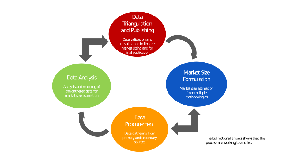
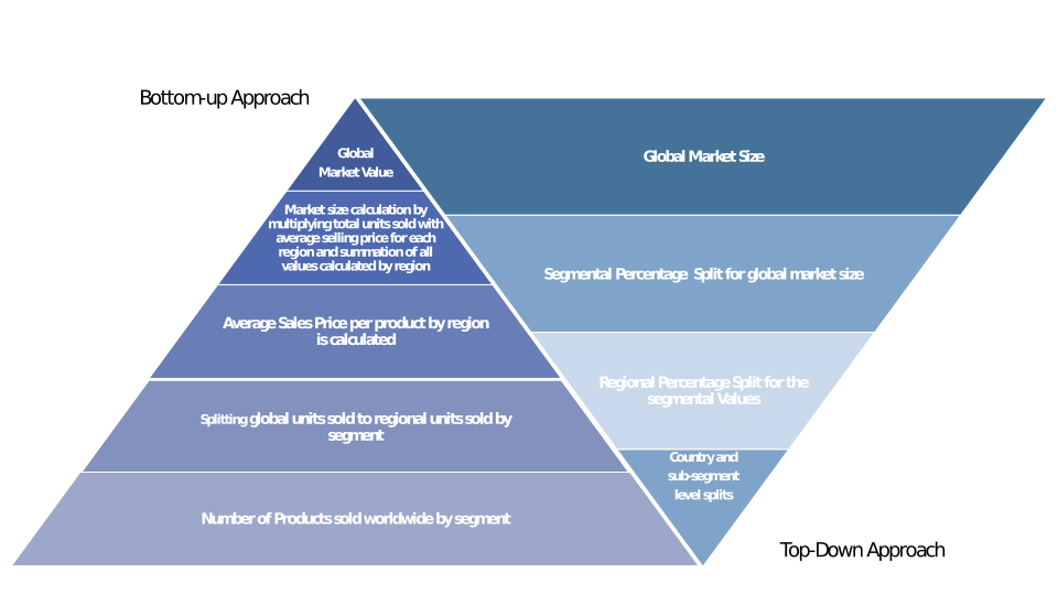
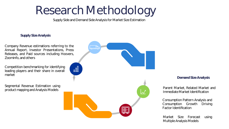
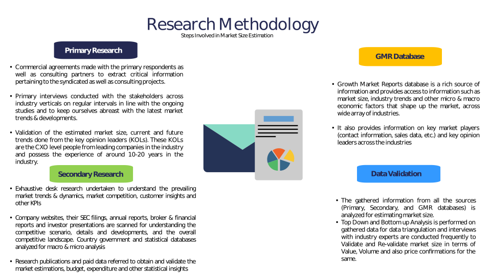
Methodology
Related Reports
Some other reports from this category!


Our Clients