
Drone-Enabled Surveying Market Size, Share & Growth Analysis, 2026-2034
Drone-Enabled Surveying Market Size, Share & Growth Analysis, 2026-2034
Segments - by Offering (Hardware, Software, Services), by Application (Land Surveying, Construction & Infrastructure, Mining, Agriculture, Environmental Monitoring, Oil & Gas, Others), by End-User (Construction, Agriculture, Mining, Energy & Utilities, Environmental, Others), by Drone Type (Fixed-Wing, Rotary-Wing, Hybrid)



Last Updated : Jun, 2026
| Report ID :AD-12185
| 4.3 Rating
| 60 Reviews
| 293 Pages
| Format :


Drone-Enabled Surveying Market: Key Numbers
The Drone-Enabled Surveying market was valued at USD 2.71 Billion in 2025 and is projected to reach USD 9.48 Billion by 2034, a CAGR of 15.9%.
| Market size (2025) | USD 2.71 Billion |
|---|---|
| Forecast (2034) | USD 9.48 Billion |
| CAGR (2026-2034) | 15.9% |
| Largest region | North America |
| Segments covered | Offering, Application, End-User, Drone Type |
| Key companies | DJI, Parrot SA, Trimble Inc., AgEagle Aerial Systems (senseFly), Delair |
This report is updated with the latest market data and insights as of June 2026. Base year: 2025 | Forecast period: 2026-2034
Drone-Enabled Surveying Market Size and Growth Outlook
Research by Growth Market Reports shows that the global drone-enabled surveying market size reached USD 2.71 billion in 2025, driven by rapid advancements in drone technology, increasing adoption across diverse industries, and a growing need for efficient, high-precision mapping solutions. The market is expected to grow at a robust CAGR of 15.9% from 2026 to 2034, reaching an estimated USD 9.48 billion by 2034. The primary growth factor fueling this market is the rising demand for accurate, real-time data collection and analysis in sectors such as construction, agriculture, mining, and environmental monitoring, where traditional surveying methods are increasingly being replaced by drone-enabled solutions for enhanced efficiency and cost-effectiveness.

The growth of the drone-enabled surveying market is significantly influenced by the rapid evolution of drone hardware and sensor technologies. Modern drones deployed in 2025 are equipped with high-resolution cameras, LiDAR, multispectral sensors, and advanced GNSS systems, enabling them to capture highly accurate geospatial data over vast and difficult terrains. This technological advancement has greatly reduced the time and labor required for land surveying, making it possible to gather comprehensive data in a fraction of the time compared to conventional methods. Additionally, the integration of artificial intelligence and machine learning algorithms in drone software is enhancing data processing capabilities, enabling real-time analytics and automated reporting. These innovations are not only improving the quality and precision of survey data but also expanding the range of applications for drone-enabled surveying across multiple industries. Operators specializing in professional drone surveying services are scaling rapidly, capturing significant project volumes from enterprise clients across construction, energy, and environmental sectors.
Another major factor propelling the drone-enabled surveying market is the growing regulatory support and standardization of drone operations worldwide. Governments and regulatory bodies are increasingly recognizing the benefits of drone technology in surveying and mapping, leading to the formulation of guidelines and policies that facilitate safe and legal drone usage. The progressive expansion of Beyond Visual Line of Sight (BVLOS) authorizations, coupled with the introduction of remote identification requirements and unmanned traffic management (UTM) systems, is encouraging more organizations to adopt drones for surveying activities. Furthermore, the declining cost of drone hardware and the availability of user-friendly software solutions are making drone-enabled surveying accessible to small and medium enterprises, thereby democratizing the technology and fueling market expansion through 2034.
The versatility of drones in surveying applications is also a critical growth driver. Drones are being widely adopted for land surveying, construction site monitoring, agricultural field mapping, environmental impact assessments, and resource exploration in mining and oil and gas sectors. Their ability to provide high-resolution aerial imagery, generate 3D terrain models, and monitor changes over time is proving invaluable for project planning, progress tracking, and risk management. As industries increasingly prioritize sustainability and operational efficiency, drone-enabled surveying is emerging as a preferred solution for minimizing environmental impact, optimizing resource utilization, and improving safety by reducing the need for human intervention in hazardous environments. The expanding use of mapping and surveying drone platforms across both developed and emerging economies reflects how mainstream this technology has become in 2025.
Aerial Survey techniques have revolutionized the way data is collected and analyzed in the surveying industry. By utilizing drones for aerial surveys, companies can capture high-resolution images and geospatial data over large areas with unprecedented speed and accuracy. This method allows for the creation of detailed topographic maps and 3D models, which are essential for various applications such as urban planning, environmental monitoring, and infrastructure development. The ability to conduct aerial surveys quickly and efficiently reduces the time and labor costs associated with traditional ground-based methods, making it an attractive option for industries seeking to optimize their operations and improve decision-making processes.
Regionally, North America and Europe are leading the adoption of drone-enabled surveying solutions, driven by strong technological infrastructure, supportive regulatory frameworks, and high investments in construction, agriculture, and energy sectors. The Asia Pacific region, however, is witnessing the fastest growth, fueled by rapid urbanization, large-scale infrastructure projects, and increasing government initiatives to promote smart agriculture and environmental monitoring. Countries such as China, India, Japan, and Australia are at the forefront of integrating drone technology into their surveying practices, creating significant opportunities for market players. Meanwhile, Latin America and the Middle East and Africa are gradually embracing drone-enabled surveying, particularly in mining, oil and gas, and environmental conservation projects, contributing to the global market's overall expansion through 2034.
Drone-Enabled Surveying Market by Offering
The offering segment of the drone-enabled surveying market is broadly categorized into hardware, software, and services, each playing a pivotal role in the overall ecosystem. Hardware forms the backbone of the market, accounting for approximately 48.5% of total revenue in 2025, encompassing drones, cameras, LiDAR sensors, GNSS modules, and other essential components. The demand for advanced hardware is surging as industries seek drones with higher payload capacities, extended flight times, and improved durability to withstand challenging environmental conditions. The proliferation of lightweight composite materials, modular designs, and swappable payload systems is further enhancing the adaptability and efficiency of drone hardware, enabling users to customize their equipment for specific surveying applications. As competition among hardware manufacturers intensifies, the market is witnessing continuous innovation, leading to the introduction of cost-effective and highly capable drones that cater to a wide range of end-user requirements.

Software accounts for approximately 28.0% of the market in 2025 and represents one of the fastest-growing sub-segments. Modern drone software solutions offer advanced functionalities such as automated flight planning, real-time data capture, AI-powered image stitching, 3D point cloud modeling, and cloud-based data storage and collaboration. The integration of artificial intelligence and machine learning is enabling software platforms to deliver actionable insights, automate complex data processing workflows, and enhance decision-making capabilities for users across industries. The shift towards SaaS (Software-as-a-Service) models is making sophisticated surveying tools accessible to a broader audience, reducing the need for extensive IT infrastructure and lowering barriers to entry for small and medium enterprises. Platforms supporting advanced drone mapping workflows are particularly in demand, as organizations seek end-to-end solutions from flight planning through final deliverable generation. As the complexity of surveying projects increases, the demand for intuitive, scalable, and interoperable software solutions is expected to accelerate through 2034.
The services segment, contributing approximately 23.5% of the market in 2025, encompasses a wide array of offerings including drone surveying, data processing, consulting, training, and maintenance. Service providers play a crucial role in bridging the gap between technology and end-users, offering expertise in drone operation, regulatory compliance, and geospatial data interpretation. The growing trend of outsourcing surveying and mapping activities to specialized service providers is driven by the need for cost savings, access to advanced technology, and the ability to scale operations quickly. As industries increasingly recognize the value of professional drone surveying services, the market is witnessing the emergence of new business models, such as pay-per-use and subscription-based arrangements, which are making drone-enabled surveying more affordable and flexible for a diverse range of customers.
The interplay between hardware, software, and services is creating a dynamic and competitive landscape in the drone-enabled surveying market. Market players are increasingly focusing on offering integrated solutions that combine state-of-the-art drones, powerful software platforms, and comprehensive support services to deliver end-to-end value to customers. Strategic partnerships, mergers, and acquisitions are becoming common as companies seek to expand their product portfolios, enhance technological capabilities, and strengthen their market presence. As the market continues to evolve through 2034, the ability to deliver seamless, interoperable, and user-centric offerings will be a key differentiator for success in the highly competitive drone-enabled surveying industry.
Drone-Enabled Surveying Market Report Scope
| Attributes | Details |
| Report Title | Drone-Enabled Surveying Market Research Report 2034 |
| By Offering | Hardware, Software, Services |
| By Application | Land Surveying, Construction & Infrastructure, Mining, Agriculture, Environmental Monitoring, Oil & Gas, Others |
| By End-User | Construction, Agriculture, Mining, Energy & Utilities, Environmental, Others |
| By Drone Type | Fixed-Wing, Rotary-Wing, Hybrid |
| Regions Covered | North America, Europe, APAC, Latin America, MEA |
| Base Year | 2025 |
| Historic Data | 2019-2024 |
| Forecast Period | 2026-2034 |
| Number of Pages | 293 |
| Number of Tables & Figures | 251 |
| Customization Available | Yes, the report can be customized as per your need. |
Drone-Enabled Surveying Market by Application
The application segment of the drone-enabled surveying market is highly diverse, reflecting the wide-ranging utility of drone technology across various industries. Land surveying remains one of the most prominent applications in 2025, with drones being used to capture high-resolution aerial imagery, generate topographic maps, and create detailed 3D models of terrain. The ability to quickly and accurately survey large areas is revolutionizing land management, urban planning, and infrastructure development projects globally. Drones are also playing a pivotal role in construction and infrastructure monitoring, enabling real-time progress tracking, site inspections, and quality control. By providing up-to-date data on construction sites, drones are helping project managers identify potential issues early, optimize resource allocation, and improve overall project efficiency.
In the mining sector, drones are being increasingly adopted for exploration, mapping, and volumetric analysis. The ability to safely survey hazardous or inaccessible areas is reducing the risks associated with traditional surveying methods while improving the accuracy of resource estimation and extraction planning. Drones equipped with multispectral and thermal sensors are also being used to monitor environmental impacts, track changes in land use, and ensure compliance with regulatory requirements. The agriculture industry is another major beneficiary of drone-enabled surveying, with drones providing actionable insights into soil conditions, plant health, and irrigation needs, enabling farmers to optimize inputs, increase productivity, and reduce environmental impact. Specialized applications such as drone-enabled wildlife surveys are gaining particular traction in conservation-focused projects, where traditional ground methods are impractical or disruptive to sensitive habitats.
Environmental monitoring is emerging as a critical application area for drone-enabled surveying, driven by the need to track changes in ecosystems, monitor wildlife populations, and assess the impacts of climate change. Drones are being deployed to collect data on deforestation, water quality, coastal erosion, and disaster-affected areas, providing researchers and policymakers with the information needed to make informed decisions. In the oil and gas sector, drones are being used for pipeline inspection, asset management, and spill detection, enhancing safety and operational efficiency while minimizing downtime and maintenance costs. The versatility of drone technology is enabling its adoption in a wide range of other applications, including forestry management, archaeology, renewable energy asset inspection, and disaster response, further expanding the scope of the drone-enabled surveying market through 2034.
The growing demand for application-specific solutions is driving innovation in drone design, sensor integration, and data analytics. Market players are increasingly focusing on developing tailored solutions that address the unique requirements of different industries, such as ruggedized drones for mining, multispectral sensors for agriculture, and long-endurance platforms for environmental monitoring. The ability to deliver customized, industry-specific solutions is becoming a key competitive advantage in the drone-enabled surveying market, enabling companies to capture new opportunities and sustain growth over the 2026-2034 forecast period.
Drone-Enabled Surveying Market by End-User
The end-user segment of the drone-enabled surveying market is witnessing significant diversification as more industries recognize the benefits of drone technology in 2025. The construction industry remains a major end-user, leveraging drones for site surveys, progress monitoring, and quality assurance. The ability to capture real-time data and generate accurate 3D models is helping construction companies streamline project management, reduce costs, and improve safety. Drones are also being used to monitor critical infrastructure such as roads, bridges, railways, and tunnels, enabling timely maintenance and reducing the risk of structural failures.
The agriculture sector is rapidly embracing drone-enabled surveying for precision farming, crop monitoring, and land management. Drones equipped with multispectral and thermal sensors are providing farmers with valuable insights into soil health, crop growth, and irrigation requirements, enabling data-driven decisions and optimized resource utilization. The adoption of drone technology is helping farmers increase yields, reduce input costs, and minimize environmental impact, making it a key enabler of sustainable agriculture globally. Complementary solutions such as drone-based line-of-sight survey techniques are also being integrated into agricultural workflows to support rural infrastructure planning and utility corridor assessments.
Mining is another major end-user of drone-enabled surveying in 2025, with drones being deployed for exploration, pit mapping, and volume estimation. The ability to safely and efficiently survey large and hazardous areas is improving resource management, reducing operational risks, and enhancing safety for workers. Energy and utilities companies are leveraging drone-enabled surveying for asset inspection, maintenance planning, and environmental monitoring. Drones are being used to inspect power lines, wind turbines, solar farms, and pipelines, reducing the need for manual inspections and minimizing downtime. Environmental organizations and government agencies are increasingly adopting drone-enabled surveying for ecosystem monitoring, environmental impact assessments, and natural disaster response, providing valuable insights for conservation and emergency management efforts.
Drone-Enabled Surveying Market by Drone Type
The drone type segment of the drone-enabled surveying market is primarily divided into fixed-wing, rotary-wing, and hybrid drones, each offering unique advantages for different surveying applications. Fixed-wing drones are renowned for their long endurance, high cruise speed, and ability to cover large areas in a single flight, making them ideal for applications such as large-scale land surveying, agricultural mapping, and environmental monitoring. Their aerodynamic design allows for efficient flight over extended distances, enabling the collection of high-resolution data across vast and remote terrains. Platforms in this category from companies such as AgEagle Aerial Systems and Wingtra AG are widely deployed in enterprise-grade surveying projects in 2025.
Rotary-wing drones, including quadcopters and hexacopters, are highly maneuverable and capable of vertical takeoff and landing, making them well-suited for surveying applications in complex or restricted environments. Their ability to hover in place and navigate around obstacles is particularly valuable for construction site monitoring, infrastructure inspection, and mining operations. Rotary-wing drones are also favored for their ease of deployment, user-friendly operation, and versatility in carrying a wide range of sensors and payloads. Solutions in this category span from drone-based roof and structure surveys in urban environments to detailed facility inspections in industrial settings.
Hybrid drones are emerging as a high-growth category in 2025, combining the endurance and coverage capabilities of fixed-wing platforms with the maneuverability and vertical takeoff and landing features of rotary-wing drones. These innovative platforms are gaining significant traction in the drone-enabled surveying market for applications that require both long-range data collection and the ability to operate in challenging or confined environments. Hybrid drones are being increasingly adopted for complex surveying projects in agriculture, mining, and environmental monitoring, where flexibility and efficiency are critical requirements over the 2026-2034 forecast period.
The choice of drone type is often influenced by the specific requirements of the surveying application, including the size of the area to be surveyed, the complexity of the terrain, and the desired level of data accuracy. Market players are continuously innovating to develop drones that offer improved flight performance, enhanced payload capacities, and greater operational reliability. The integration of advanced sensors, AI-powered autonomous navigation systems, and automated flight planning tools is further enhancing the capabilities of all drone types, enabling them to meet the evolving needs of end-users across industries through 2034.
Drone-Enabled Surveying Market Opportunities and Threats
The drone-enabled surveying market presents significant opportunities for growth and innovation from 2025 through 2034, driven by the increasing adoption of drones across a wide range of industries. The demand for high-precision, real-time data collection is creating opportunities for market players to develop advanced hardware, software, and service solutions that address the unique needs of different applications. The integration of artificial intelligence, machine learning, digital twin technology, and cloud computing is enabling the development of intelligent surveying platforms that can automate data processing, generate actionable insights, and streamline decision-making for end-users. The expansion of drone-enabled surveying into emerging use cases, such as smart city infrastructure monitoring, renewable energy asset management, and environmental conservation, is opening up new avenues for growth and diversification.
Another major opportunity lies in the continued development of regulatory frameworks that facilitate safe and efficient drone operations globally. As governments and regulatory bodies recognize the economic and societal benefits of drone technology, the progressive introduction of BVLOS authorization pathways, standardized remote identification systems, and advanced airspace management tools is expected to drive wider adoption of drone-enabled surveying solutions. Growing public-private partnerships and government-funded digital transformation initiatives in sectors such as agriculture, infrastructure, and environmental monitoring are creating additional opportunities for market players to collaborate with stakeholders and expand their market reach. The increasing corporate focus on sustainability and environmental stewardship is also driving demand for drone-enabled surveying solutions that minimize environmental footprint while supporting responsible resource management.
Despite the significant opportunities, the drone-enabled surveying market faces several challenges that could moderate growth. One of the primary restraining factors is the complex and fragmented global regulatory landscape, which creates compliance uncertainty and operational complexity for market players operating across multiple jurisdictions. Restrictions on drone flight operations in certain airspace categories, growing privacy concerns related to aerial data collection, and cybersecurity risks associated with cloud-based data transmission are potential barriers to adoption in sensitive or highly regulated industries. Additionally, the high initial investment required for advanced drone hardware and software, combined with the need for skilled operators and geospatial data analysts, can limit accessibility for smaller organizations. Addressing these challenges requires ongoing collaboration between industry stakeholders, regulators, and technology providers to develop solutions that balance innovation, safety, privacy, and regulatory compliance.
Drone-Enabled Surveying Market Size by Region
North America remains the second-largest regional market for drone-enabled surveying, accounting for approximately 31.2% of total market revenue in 2025, equivalent to roughly USD 845 million. The region is driven by strong technological infrastructure, supportive regulatory frameworks such as FAA Part 107 and evolving BVLOS provisions, and high investments in construction, precision agriculture, and energy sectors. The United States leads the region in terms of adoption, with widespread deployment of drones in land surveying, infrastructure monitoring, and environmental assessment. The presence of leading drone manufacturers, software developers, and geospatial service providers is further bolstering market growth in North America. The region is expected to grow at a steady CAGR of approximately 14.8% through 2034, supported by ongoing technological innovation, favorable government policies, and increasing demand for advanced surveying solutions.

Europe is a key regional market for drone-enabled surveying, contributing approximately 21.4% of global market share in 2025, with a market value of roughly USD 580 million. The region is characterized by strong regulatory standardization through EASA frameworks, a high emphasis on sustainability, and significant investments in infrastructure development and environmental monitoring. Countries such as Germany, France, the United Kingdom, and the Netherlands are at the forefront of adopting drone technology for land management, precision agriculture, and renewable energy asset inspection. The European market is expected to grow at a CAGR of approximately 14.2% through 2034, driven by increasing government support, rising awareness of drone-enabled surveying benefits, and the expansion of smart city and green infrastructure initiatives.
The Asia Pacific region leads the global drone-enabled surveying market in terms of growth momentum, holding approximately 33.6% of global market share in 2025, with a market value of approximately USD 910 million. Rapid urbanization, large-scale infrastructure development programs, and government-backed initiatives to promote drone use in agriculture, mining, and environmental monitoring are fueling market expansion in China, India, Japan, South Korea, and Australia. China remains the dominant country in terms of hardware production and deployment volumes, while India and Southeast Asian nations represent high-growth opportunity markets. The Asia Pacific region is forecast to grow at a leading CAGR of approximately 17.1% through 2034. Latin America and the Middle East and Africa together account for approximately 13.8% of the global market in 2025, with growing adoption particularly in mining, oil and gas, and environmental conservation applications. These regions are expected to deliver steady growth as awareness, investment, and infrastructure supporting drone-enabled surveying continue to develop through 2034.
Drone-Enabled Surveying Market Competitive Landscape
The drone-enabled surveying market in 2025 is characterized by intense competition and rapid technological innovation, with a diverse array of players ranging from established multinational corporations to agile, venture-backed startups. The competitive landscape is shaped by continuous advancements in drone hardware, sensor integration, software development, and professional service delivery, as companies strive to differentiate themselves through product quality, innovation, and customer support. Strategic partnerships, mergers, and acquisitions are common as market participants seek to expand their product portfolios, enhance technological capabilities, and strengthen their global market presence. The ability to offer integrated, end-to-end solutions that combine advanced drone platforms, powerful data processing software, and comprehensive operational support services is becoming a key differentiator for success in this rapidly evolving market.
Leading companies are investing heavily in research and development to create drones with enhanced flight performance, greater payload capacities, improved sensor fusion, and extended operational reliability under demanding field conditions. The integration of artificial intelligence, machine learning, and cloud computing is enabling the development of intelligent surveying platforms that automate complex data processing tasks, generate actionable geospatial insights, and streamline decision-making workflows for enterprise users. Companies are also focusing on developing user-friendly software ecosystems that cater to the needs of both experienced geospatial professionals and new entrants, making drone-enabled surveying increasingly accessible to a broader audience globally.
The services segment is attracting a growing cohort of specialized providers offering professional drone surveying, consulting, data processing, and maintenance services. These companies play a crucial role in helping end-users navigate the complexities of drone operation, regulatory compliance, and geospatial data interpretation, thereby accelerating the adoption of drone-enabled surveying solutions across industries and geographies.
Major companies operating in the drone-enabled surveying market include DJI, the global leader in consumer and professional drone manufacturing, and Trimble Inc., which offers integrated surveying solutions combining advanced GNSS technology, drone platforms, and software. AgEagle Aerial Systems (which acquired senseFly) and Delair are recognized for their professional fixed-wing drones and industry-tailored data solutions. Wingtra AG has gained significant recognition for its high-precision hybrid VTOL surveying drones widely used in professional mapping. Microdrones and Quantum Systems offer enterprise-grade platforms with advanced sensor integration capabilities. On the software side, Pix4D and DroneDeploy remain the leading data processing and analytics platforms, while Skycatch focuses on construction site intelligence. Leica Geosystems (Hexagon AB), Topcon Positioning Systems, RIEGL Laser Measurement Systems, and EagleView Technologies provide precision sensors, LiDAR systems, and aerial analytics solutions. Terra Drone Corporation leads in Asia-based drone services, while AeroVironment and Percepto are prominent for autonomous inspection and defense-adjacent applications. Teledyne FLIR and Yuneec International round out the competitive landscape with thermal sensor integration and multi-rotor platform expertise respectively.
In summary, the drone-enabled surveying market is poised for robust growth from 2025 through 2034, driven by continuous technological advancement, expanding application scope, and accelerating adoption across industries and regions globally. Market players that can deliver integrated, innovative, and customer-centric solutions, while navigating an evolving regulatory environment and managing cost pressures, will be well-positioned to capitalize on the significant opportunities presented by this dynamic and rapidly expanding market.
Top Companies in the Drone-Enabled Surveying Market
- DJI
- Parrot SA
- Trimble Inc.
- AgEagle Aerial Systems (senseFly)
- Delair
- AeroVironment Inc.
- Quantum Systems
- Microdrones
- Yuneec International
- Teledyne FLIR
- DroneDeploy
- Skycatch
- RIEGL Laser Measurement Systems
- Topcon Positioning Systems
- Leica Geosystems (Hexagon AB)
- Pix4D
- Terra Drone Corporation
- WingtraOne (Wingtra AG)
- Percepto
- EagleView Technologies
Segments
The Drone-Enabled Surveying market has been segmented on the basis of
Offering
- Hardware
- Software
- Services
Application
- Land Surveying
- Construction & Infrastructure
- Mining
- Agriculture
- Environmental Monitoring
- Oil & Gas
- Others
End-User
- Construction
- Agriculture
- Mining
- Energy & Utilities
- Environmental
- Others
Drone Type
- Fixed-Wing
- Rotary-Wing
- Hybrid
Frequently Asked Questions
Regulatory evolution is both a driver and a constraint for the drone-enabled surveying market. In 2025, major jurisdictions including the United States (FAA), the European Union (EASA), and China (CAAC) have established clearer operational frameworks for commercial drone use, including Beyond Visual Line of Sight (BVLOS) authorization pathways, remote identification requirements, and tiered risk classification systems. These frameworks are increasing operational confidence and accelerating enterprise adoption. However, regulatory fragmentation across countries and ongoing revisions create compliance complexity for globally operating companies. The anticipated rollout of urban air mobility corridors and unmanned traffic management (UTM) systems over the 2026-2034 forecast period is expected to further streamline drone operations and unlock new high-value surveying applications.
Drone-enabled surveying serves a broad spectrum of applications. Land surveying and topographic mapping are foundational use cases, supporting urban planning, land administration, and infrastructure development. Construction and infrastructure monitoring encompasses progress tracking, quality control, and site safety inspections. In mining, drones perform volumetric calculations, pit mapping, and tailings monitoring. Agriculture applications include crop health analysis, irrigation planning, soil mapping, and yield estimation using multispectral sensors. Environmental monitoring covers deforestation tracking, wetland assessment, coastal erosion surveys, and wildlife habitat mapping. The oil and gas sector uses drones for pipeline inspection, leak detection, and remote facility monitoring. Emerging applications in forestry, archaeology, disaster response, and renewable energy asset inspection continue to expand market scope through 2034.
The global drone-enabled surveying market features a mix of hardware manufacturers, software developers, and integrated solution providers. Leading companies include DJI, the dominant hardware supplier globally, alongside Trimble Inc., which offers integrated surveying solutions combining GNSS and drone technology. AgEagle Aerial Systems (formerly senseFly), Delair, Wingtra AG, Microdrones, and Quantum Systems are recognized for their professional fixed-wing and hybrid platforms. Pix4D, DroneDeploy, and Skycatch lead in data processing and analytics software. Leica Geosystems (Hexagon AB), Topcon Positioning Systems, and RIEGL Laser Measurement Systems are prominent for precision sensors and LiDAR integration. Terra Drone Corporation, AeroVironment, and Percepto round out the competitive landscape with specialized service and autonomous inspection offerings.
The market faces several challenges, including a complex and evolving global regulatory environment that creates compliance uncertainty for operators. Privacy concerns related to aerial data collection, cybersecurity risks from cloud-based data transmission, and restrictions on drone flights in sensitive airspace remain significant barriers. High upfront costs for advanced hardware and software, combined with a shortage of skilled drone pilots and geospatial data analysts, can limit adoption among smaller organizations. Weather dependency, limited payload capacity in some drone categories, and data interoperability issues between platforms also pose operational challenges. Ongoing collaboration between regulators, technology developers, and end-users is essential to address these barriers through 2034.
Software accounts for approximately 28.0% of the market in 2025 and is one of the fastest-growing sub-segments. Modern drone software platforms provide automated flight planning, real-time data capture, AI-powered image processing, 3D point cloud generation, and cloud-based collaboration tools. The shift to Software-as-a-Service (SaaS) models is lowering barriers for small and medium enterprises, democratizing access to sophisticated surveying capabilities. Integration with geographic information systems (GIS), building information modeling (BIM), and enterprise resource planning (ERP) tools is expanding software utility, while continuous AI-driven improvements in accuracy and automation are further accelerating adoption across all end-user industries.
The drone-enabled surveying market is segmented into fixed-wing, rotary-wing, and hybrid drone types. Fixed-wing drones are preferred for large-area surveys in agriculture, environmental monitoring, and land mapping due to their long flight endurance and high-speed coverage. Rotary-wing drones, including quadcopters and hexacopters, dominate construction site monitoring and infrastructure inspection because of their maneuverability and vertical takeoff and landing capabilities. Hybrid drones are gaining rapid traction in 2025, combining the endurance of fixed-wing platforms with the flexibility of rotary designs, making them ideal for complex, multi-terrain surveying projects in mining and environmental sectors.
Asia Pacific is the fastest-growing region, accounting for approximately 33.6% of the global market in 2025, propelled by rapid urbanization, large-scale infrastructure projects, and government-backed smart agriculture programs in China, India, Japan, and Australia. North America holds the largest share at roughly 31.2%, supported by advanced regulatory frameworks, strong technology investment, and widespread adoption across construction, energy, and agriculture. Europe follows with around 21.4%, driven by sustainability mandates, smart city initiatives, and precision agriculture programs. Latin America and the Middle East and Africa collectively account for the remaining share and are emerging growth markets, particularly in mining and oil and gas applications.
Key technological advancements include the integration of LiDAR sensors, high-resolution multispectral and thermal cameras, and advanced GNSS modules that enable centimeter-level accuracy. Artificial intelligence and machine learning are transforming data processing, enabling automated image stitching, real-time analytics, and predictive modeling. The proliferation of cloud-based platforms facilitates seamless data storage and collaboration. Additionally, improvements in battery technology, lightweight composite materials, and autonomous flight planning software are extending drone endurance and operational range, making large-scale surveys faster and more cost-effective in 2025 and beyond.
Construction and infrastructure, agriculture, mining, energy and utilities, and environmental monitoring are the primary industries driving adoption. Construction firms rely on drones for site surveys and progress tracking, while the agriculture sector uses them for precision farming and crop health monitoring. Mining companies leverage drones for volumetric analysis and hazardous area surveys, and energy operators deploy them for pipeline and asset inspections. Environmental agencies increasingly depend on drones for ecosystem monitoring, wildlife surveys, and disaster response, all contributing to robust market demand through 2034.
The global drone-enabled surveying market reached USD 2.71 billion in 2025 and is projected to grow at a CAGR of 15.9% from 2026 to 2034, reaching an estimated USD 9.48 billion by 2034. This growth is driven by rapid advancements in drone hardware and sensor technology, increasing cross-industry adoption, and a rising demand for high-precision, real-time geospatial data collection solutions.
Table Of Content
Chapter 1 Executive SummaryChapter 2 Assumptions and Acronyms Used
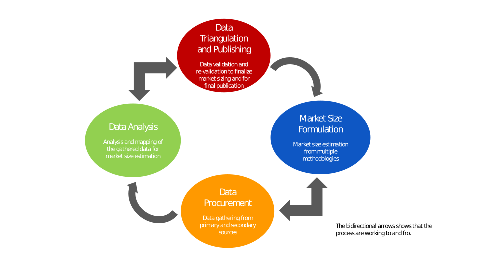
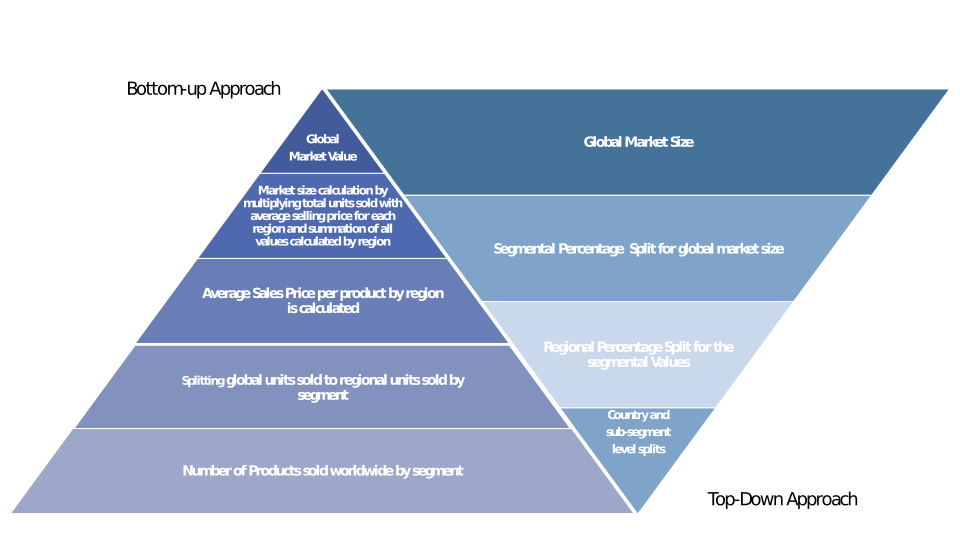
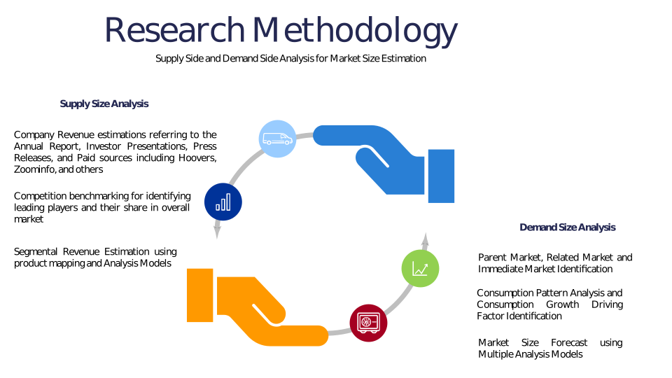
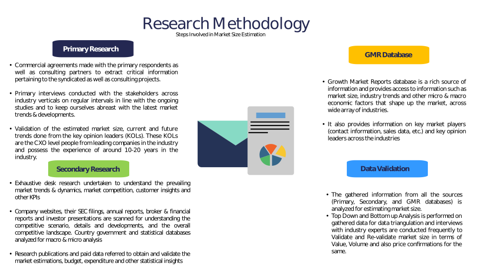
Chapter 3 Research Methodology
Chapter 4 Drone-Enabled Surveying Market Overview
4.1 Introduction
4.1.1 Market Taxonomy
4.1.2 Market Definition
4.1.3 Macro-Economic Factors Impacting the Market Growth
4.2 Drone-Enabled Surveying Market Dynamics
4.2.1 Market Drivers
4.2.2 Market Restraints
4.2.3 Market Opportunity
4.3 Drone-Enabled Surveying Market - Supply Chain Analysis
4.3.1 List of Key Suppliers
4.3.2 List of Key Distributors
4.3.3 List of Key Consumers
4.4 Key Forces Shaping the Drone-Enabled Surveying Market
4.4.1 Bargaining Power of Suppliers
4.4.2 Bargaining Power of Buyers
4.4.3 Threat of Substitution
4.4.4 Threat of New Entrants
4.4.5 Competitive Rivalry
4.5 Global Drone-Enabled Surveying Market Size & Forecast, 2023-2032
4.5.1 Drone-Enabled Surveying Market Size and Y-o-Y Growth
4.5.2 Drone-Enabled Surveying Market Absolute $ Opportunity
Chapter 5 Global Drone-Enabled Surveying Market Analysis and Forecast By Offering
5.1 Introduction
5.1.1 Key Market Trends & Growth Opportunities By Offering
5.1.2 Basis Point Share (BPS) Analysis By Offering
5.1.3 Absolute $ Opportunity Assessment By Offering
5.2 Drone-Enabled Surveying Market Size Forecast By Offering
5.2.1 Hardware
5.2.2 Software
5.2.3 Services
5.3 Market Attractiveness Analysis By Offering
Chapter 6 Global Drone-Enabled Surveying Market Analysis and Forecast By Application
6.1 Introduction
6.1.1 Key Market Trends & Growth Opportunities By Application
6.1.2 Basis Point Share (BPS) Analysis By Application
6.1.3 Absolute $ Opportunity Assessment By Application
6.2 Drone-Enabled Surveying Market Size Forecast By Application
6.2.1 Land Surveying
6.2.2 Construction & Infrastructure
6.2.3 Mining
6.2.4 Agriculture
6.2.5 Environmental Monitoring
6.2.6 Oil & Gas
6.2.7 Others
6.3 Market Attractiveness Analysis By Application
Chapter 7 Global Drone-Enabled Surveying Market Analysis and Forecast By End-User
7.1 Introduction
7.1.1 Key Market Trends & Growth Opportunities By End-User
7.1.2 Basis Point Share (BPS) Analysis By End-User
7.1.3 Absolute $ Opportunity Assessment By End-User
7.2 Drone-Enabled Surveying Market Size Forecast By End-User
7.2.1 Construction
7.2.2 Agriculture
7.2.3 Mining
7.2.4 Energy & Utilities
7.2.5 Environmental
7.2.6 Others
7.3 Market Attractiveness Analysis By End-User
Chapter 8 Global Drone-Enabled Surveying Market Analysis and Forecast By Drone Type
8.1 Introduction
8.1.1 Key Market Trends & Growth Opportunities By Drone Type
8.1.2 Basis Point Share (BPS) Analysis By Drone Type
8.1.3 Absolute $ Opportunity Assessment By Drone Type
8.2 Drone-Enabled Surveying Market Size Forecast By Drone Type
8.2.1 Fixed-Wing
8.2.2 Rotary-Wing
8.2.3 Hybrid
8.3 Market Attractiveness Analysis By Drone Type
Chapter 9 Global Drone-Enabled Surveying Market Analysis and Forecast by Region
9.1 Introduction
9.1.1 Key Market Trends & Growth Opportunities By Region
9.1.2 Basis Point Share (BPS) Analysis By Region
9.1.3 Absolute $ Opportunity Assessment By Region
9.2 Drone-Enabled Surveying Market Size Forecast By Region
9.2.1 North America
9.2.2 Europe
9.2.3 Asia Pacific
9.2.4 Latin America
9.2.5 Middle East & Africa (MEA)
9.3 Market Attractiveness Analysis By Region
Chapter 10 Coronavirus Disease (COVID-19) Impact
10.1 Introduction
10.2 Current & Future Impact Analysis
10.3 Economic Impact Analysis
10.4 Government Policies
10.5 Investment Scenario
Chapter 11 North America Drone-Enabled Surveying Analysis and Forecast
11.1 Introduction
11.2 North America Drone-Enabled Surveying Market Size Forecast by Country
11.2.1 U.S.
11.2.2 Canada
11.3 Basis Point Share (BPS) Analysis by Country
11.4 Absolute $ Opportunity Assessment by Country
11.5 Market Attractiveness Analysis by Country
11.6 North America Drone-Enabled Surveying Market Size Forecast By Offering
11.6.1 Hardware
11.6.2 Software
11.6.3 Services
11.7 Basis Point Share (BPS) Analysis By Offering
11.8 Absolute $ Opportunity Assessment By Offering
11.9 Market Attractiveness Analysis By Offering
11.10 North America Drone-Enabled Surveying Market Size Forecast By Application
11.10.1 Land Surveying
11.10.2 Construction & Infrastructure
11.10.3 Mining
11.10.4 Agriculture
11.10.5 Environmental Monitoring
11.10.6 Oil & Gas
11.10.7 Others
11.11 Basis Point Share (BPS) Analysis By Application
11.12 Absolute $ Opportunity Assessment By Application
11.13 Market Attractiveness Analysis By Application
11.14 North America Drone-Enabled Surveying Market Size Forecast By End-User
11.14.1 Construction
11.14.2 Agriculture
11.14.3 Mining
11.14.4 Energy & Utilities
11.14.5 Environmental
11.14.6 Others
11.15 Basis Point Share (BPS) Analysis By End-User
11.16 Absolute $ Opportunity Assessment By End-User
11.17 Market Attractiveness Analysis By End-User
11.18 North America Drone-Enabled Surveying Market Size Forecast By Drone Type
11.18.1 Fixed-Wing
11.18.2 Rotary-Wing
11.18.3 Hybrid
11.19 Basis Point Share (BPS) Analysis By Drone Type
11.20 Absolute $ Opportunity Assessment By Drone Type
11.21 Market Attractiveness Analysis By Drone Type
Chapter 12 Europe Drone-Enabled Surveying Analysis and Forecast
12.1 Introduction
12.2 Europe Drone-Enabled Surveying Market Size Forecast by Country
12.2.1 Germany
12.2.2 France
12.2.3 Italy
12.2.4 U.K.
12.2.5 Spain
12.2.6 Russia
12.2.7 Rest of Europe
12.3 Basis Point Share (BPS) Analysis by Country
12.4 Absolute $ Opportunity Assessment by Country
12.5 Market Attractiveness Analysis by Country
12.6 Europe Drone-Enabled Surveying Market Size Forecast By Offering
12.6.1 Hardware
12.6.2 Software
12.6.3 Services
12.7 Basis Point Share (BPS) Analysis By Offering
12.8 Absolute $ Opportunity Assessment By Offering
12.9 Market Attractiveness Analysis By Offering
12.10 Europe Drone-Enabled Surveying Market Size Forecast By Application
12.10.1 Land Surveying
12.10.2 Construction & Infrastructure
12.10.3 Mining
12.10.4 Agriculture
12.10.5 Environmental Monitoring
12.10.6 Oil & Gas
12.10.7 Others
12.11 Basis Point Share (BPS) Analysis By Application
12.12 Absolute $ Opportunity Assessment By Application
12.13 Market Attractiveness Analysis By Application
12.14 Europe Drone-Enabled Surveying Market Size Forecast By End-User
12.14.1 Construction
12.14.2 Agriculture
12.14.3 Mining
12.14.4 Energy & Utilities
12.14.5 Environmental
12.14.6 Others
12.15 Basis Point Share (BPS) Analysis By End-User
12.16 Absolute $ Opportunity Assessment By End-User
12.17 Market Attractiveness Analysis By End-User
12.18 Europe Drone-Enabled Surveying Market Size Forecast By Drone Type
12.18.1 Fixed-Wing
12.18.2 Rotary-Wing
12.18.3 Hybrid
12.19 Basis Point Share (BPS) Analysis By Drone Type
12.20 Absolute $ Opportunity Assessment By Drone Type
12.21 Market Attractiveness Analysis By Drone Type
Chapter 13 Asia Pacific Drone-Enabled Surveying Analysis and Forecast
13.1 Introduction
13.2 Asia Pacific Drone-Enabled Surveying Market Size Forecast by Country
13.2.1 China
13.2.2 Japan
13.2.3 South Korea
13.2.4 India
13.2.5 Australia
13.2.6 South East Asia (SEA)
13.2.7 Rest of Asia Pacific (APAC)
13.3 Basis Point Share (BPS) Analysis by Country
13.4 Absolute $ Opportunity Assessment by Country
13.5 Market Attractiveness Analysis by Country
13.6 Asia Pacific Drone-Enabled Surveying Market Size Forecast By Offering
13.6.1 Hardware
13.6.2 Software
13.6.3 Services
13.7 Basis Point Share (BPS) Analysis By Offering
13.8 Absolute $ Opportunity Assessment By Offering
13.9 Market Attractiveness Analysis By Offering
13.10 Asia Pacific Drone-Enabled Surveying Market Size Forecast By Application
13.10.1 Land Surveying
13.10.2 Construction & Infrastructure
13.10.3 Mining
13.10.4 Agriculture
13.10.5 Environmental Monitoring
13.10.6 Oil & Gas
13.10.7 Others
13.11 Basis Point Share (BPS) Analysis By Application
13.12 Absolute $ Opportunity Assessment By Application
13.13 Market Attractiveness Analysis By Application
13.14 Asia Pacific Drone-Enabled Surveying Market Size Forecast By End-User
13.14.1 Construction
13.14.2 Agriculture
13.14.3 Mining
13.14.4 Energy & Utilities
13.14.5 Environmental
13.14.6 Others
13.15 Basis Point Share (BPS) Analysis By End-User
13.16 Absolute $ Opportunity Assessment By End-User
13.17 Market Attractiveness Analysis By End-User
13.18 Asia Pacific Drone-Enabled Surveying Market Size Forecast By Drone Type
13.18.1 Fixed-Wing
13.18.2 Rotary-Wing
13.18.3 Hybrid
13.19 Basis Point Share (BPS) Analysis By Drone Type
13.20 Absolute $ Opportunity Assessment By Drone Type
13.21 Market Attractiveness Analysis By Drone Type
Chapter 14 Latin America Drone-Enabled Surveying Analysis and Forecast
14.1 Introduction
14.2 Latin America Drone-Enabled Surveying Market Size Forecast by Country
14.2.1 Brazil
14.2.2 Mexico
14.2.3 Rest of Latin America (LATAM)
14.3 Basis Point Share (BPS) Analysis by Country
14.4 Absolute $ Opportunity Assessment by Country
14.5 Market Attractiveness Analysis by Country
14.6 Latin America Drone-Enabled Surveying Market Size Forecast By Offering
14.6.1 Hardware
14.6.2 Software
14.6.3 Services
14.7 Basis Point Share (BPS) Analysis By Offering
14.8 Absolute $ Opportunity Assessment By Offering
14.9 Market Attractiveness Analysis By Offering
14.10 Latin America Drone-Enabled Surveying Market Size Forecast By Application
14.10.1 Land Surveying
14.10.2 Construction & Infrastructure
14.10.3 Mining
14.10.4 Agriculture
14.10.5 Environmental Monitoring
14.10.6 Oil & Gas
14.10.7 Others
14.11 Basis Point Share (BPS) Analysis By Application
14.12 Absolute $ Opportunity Assessment By Application
14.13 Market Attractiveness Analysis By Application
14.14 Latin America Drone-Enabled Surveying Market Size Forecast By End-User
14.14.1 Construction
14.14.2 Agriculture
14.14.3 Mining
14.14.4 Energy & Utilities
14.14.5 Environmental
14.14.6 Others
14.15 Basis Point Share (BPS) Analysis By End-User
14.16 Absolute $ Opportunity Assessment By End-User
14.17 Market Attractiveness Analysis By End-User
14.18 Latin America Drone-Enabled Surveying Market Size Forecast By Drone Type
14.18.1 Fixed-Wing
14.18.2 Rotary-Wing
14.18.3 Hybrid
14.19 Basis Point Share (BPS) Analysis By Drone Type
14.20 Absolute $ Opportunity Assessment By Drone Type
14.21 Market Attractiveness Analysis By Drone Type
Chapter 15 Middle East & Africa (MEA) Drone-Enabled Surveying Analysis and Forecast
15.1 Introduction
15.2 Middle East & Africa (MEA) Drone-Enabled Surveying Market Size Forecast by Country
15.2.1 Saudi Arabia
15.2.2 South Africa
15.2.3 UAE
15.2.4 Rest of Middle East & Africa (MEA)
15.3 Basis Point Share (BPS) Analysis by Country
15.4 Absolute $ Opportunity Assessment by Country
15.5 Market Attractiveness Analysis by Country
15.6 Middle East & Africa (MEA) Drone-Enabled Surveying Market Size Forecast By Offering
15.6.1 Hardware
15.6.2 Software
15.6.3 Services
15.7 Basis Point Share (BPS) Analysis By Offering
15.8 Absolute $ Opportunity Assessment By Offering
15.9 Market Attractiveness Analysis By Offering
15.10 Middle East & Africa (MEA) Drone-Enabled Surveying Market Size Forecast By Application
15.10.1 Land Surveying
15.10.2 Construction & Infrastructure
15.10.3 Mining
15.10.4 Agriculture
15.10.5 Environmental Monitoring
15.10.6 Oil & Gas
15.10.7 Others
15.11 Basis Point Share (BPS) Analysis By Application
15.12 Absolute $ Opportunity Assessment By Application
15.13 Market Attractiveness Analysis By Application
15.14 Middle East & Africa (MEA) Drone-Enabled Surveying Market Size Forecast By End-User
15.14.1 Construction
15.14.2 Agriculture
15.14.3 Mining
15.14.4 Energy & Utilities
15.14.5 Environmental
15.14.6 Others
15.15 Basis Point Share (BPS) Analysis By End-User
15.16 Absolute $ Opportunity Assessment By End-User
15.17 Market Attractiveness Analysis By End-User
15.18 Middle East & Africa (MEA) Drone-Enabled Surveying Market Size Forecast By Drone Type
15.18.1 Fixed-Wing
15.18.2 Rotary-Wing
15.18.3 Hybrid
15.19 Basis Point Share (BPS) Analysis By Drone Type
15.20 Absolute $ Opportunity Assessment By Drone Type
15.21 Market Attractiveness Analysis By Drone Type
Chapter 16 Competition Landscape
16.1 Drone-Enabled Surveying Market: Competitive Dashboard
16.2 Global Drone-Enabled Surveying Market: Market Share Analysis, 2023
16.3 Company Profiles (Details – Overview, Financials, Developments, Strategy)
16.3.1 DJI
16.3.2 Parrot SA
16.3.3 Trimble Inc.
16.3.4 AgEagle Aerial Systems (senseFly)
16.3.5 Delair
16.3.6 AeroVironment Inc.
16.3.7 Quantum Systems
16.3.8 Microdrones
16.3.9 Yuneec International
16.3.10 Teledyne FLIR
16.3.11 DroneDeploy
16.3.12 Skycatch
16.3.13 RIEGL Laser Measurement Systems
16.3.14 Topcon Positioning Systems
16.3.15 Leica Geosystems (Hexagon AB)
16.3.16 Pix4D
16.3.17 Terra Drone Corporation
16.3.18 WingtraOne (Wingtra AG)
16.3.19 Percepto
16.3.20 EagleView Technologies
Methodology
Related Reports
Some other reports from this category!


Our Clients


