Drone-Based Crop Canopy Height Model Market Size, Share & Growth Analysis, 2026-2034
Drone-Based Crop Canopy Height Model Market Size, Share & Growth Analysis, 2026-2034
Segments - by Component (Hardware, Software, Services), by Application (Precision Agriculture, Crop Monitoring, Yield Estimation, Disease Detection, Others), by Crop Type (Cereals & Grains, Fruits & Vegetables, Oilseeds & Pulses, Others), by End-User (Agricultural Enterprises, Research Institutes, Government & Regulatory Bodies, Others)



Last Updated : Jun, 2026
| Report ID :FB-11607
| 4.2 Rating
| 27 Reviews
| 275 Pages
| Format :


Drone-Based Crop Canopy Height Model Market: Key Numbers
The Drone-Based Crop Canopy Height Model market was valued at USD 491.9 Million in 2025 and is projected to reach USD 2296.4 Million by 2034, a CAGR of 19.2%.
| Market size (2025) | USD 491.9 Million |
|---|---|
| Forecast (2034) | USD 2296.4 Million |
| CAGR (2026-2034) | 19.2% |
| Largest region | North America |
| Segments covered | Component, Application, Crop Type, End-User |
| Key companies | DJI, Parrot SA, AgEagle Aerial Systems, senseFly (a Parrot Company), Trimble Inc. |
This report is updated with the latest market data and insights as of June 2026. Base year: 2025 | Forecast period: 2026-2034
Drone-Based Crop Canopy Height Model Market Size and Growth Outlook
Growth Market Reports finds that the global drone-based crop canopy height model market size reached USD 491.9 million in 2025, with a robust year-on-year growth trajectory. The market is expected to witness a compelling CAGR of 19.2% during the forecast period, propelling the market value to approximately USD 2,296.4 million by 2034. This significant growth is primarily driven by the increasing adoption of precision agriculture technologies, rising demand for real-time crop monitoring, and the growing necessity for sustainable farming practices worldwide. As per our comprehensive analysis, the integration of advanced drone-based solutions is transforming agricultural workflows, offering unprecedented accuracy in crop management and yield optimization across diverse farming systems in 2025 and beyond.

The primary growth factor fueling the drone-based crop canopy height model market is the rapid advancement in unmanned aerial vehicle (UAV) technologies and remote sensing capabilities. Modern drones equipped with high-resolution sensors, LiDAR, and multispectral cameras enable precise measurement of crop canopy heights, which is crucial for assessing plant health, biomass estimation, and optimizing irrigation and fertilization schedules. The agricultural sector is increasingly recognizing the value of data-driven decision-making, leading to widespread adoption of these technologies. In addition, the declining costs of drone hardware and the proliferation of user-friendly software platforms are lowering the entry barriers for both smallholder and large-scale farmers, further accelerating market expansion. The convergence of drone-based crop canopy analysis with advanced photogrammetry is opening entirely new dimensions of field intelligence for agronomists worldwide.
Another critical growth driver is the mounting pressure on global food systems to enhance productivity while minimizing environmental impact. With the world population projected to surpass 9 billion by 2050, the demand for efficient resource utilization and higher crop yields has never been greater. Drone-based crop canopy height models provide actionable insights that help farmers detect crop stress, manage disease outbreaks, and implement precision interventions, thereby reducing input wastage and supporting sustainable agriculture. Furthermore, government initiatives and subsidies promoting smart farming technologies are bolstering market growth, particularly in regions with high agricultural output such as North America, Europe, and Asia Pacific. Programs launched between 2019 and 2025 in these regions have collectively channeled billions of dollars into UAV-based agricultural intelligence infrastructure.
The market is also benefiting from the increasing collaboration between agricultural enterprises, research institutes, and technology providers. These partnerships are fostering innovation in drone hardware, analytics software, and service delivery models, leading to the development of comprehensive solutions tailored to diverse crop types and farming environments. The integration of artificial intelligence and machine learning algorithms is enhancing the predictive capabilities of crop canopy height models, enabling real-time monitoring and proactive farm management. Drone-based crop biomass estimation is becoming an integral complement to canopy height modeling, together providing a holistic picture of above-ground plant productivity that supports both on-farm decisions and supply chain forecasting. As a result, the drone-based crop canopy height model market is poised for sustained growth, driven by technological innovation and evolving end-user needs through 2034.
Regionally, North America held the largest share of the global market in 2025, accounting for approximately 35.5% of total revenue, followed by Asia Pacific and Europe. The United States and Canada are at the forefront of adoption, thanks to their advanced agricultural infrastructure and supportive regulatory frameworks. Meanwhile, Asia Pacific is anticipated to exhibit the highest CAGR of 22.1% during the forecast period, fueled by rapid digitalization of agriculture in countries such as China, India, and Australia. Europe remains a key market, driven by the emphasis on sustainable farming and the presence of leading agri-tech innovators. Latin America and the Middle East & Africa are gradually embracing drone-based solutions, supported by increasing investments in modernizing their agricultural sectors and expanding access to affordable UAV platforms.
Drone-Based Crop Canopy Height Model Market by Component
The drone-based crop canopy height model market is segmented by component into hardware, software, and services, each playing a pivotal role in the overall ecosystem. The hardware segment encompasses the physical drones, sensors, cameras, and other onboard equipment necessary for data acquisition. In 2025, hardware accounted for the largest market share at approximately 48.5%, primarily due to the high initial investment required for purchasing advanced UAVs and sensor technologies. The evolution of drone hardware, from fixed-wing to multi-rotor and hybrid platforms, has enabled greater flexibility, endurance, and data accuracy, making them indispensable for large-scale agricultural operations. Leading manufacturers are continuously innovating to enhance payload capacity, battery life, and sensor integration, catering to the diverse requirements of precision agriculture. The proliferation of purpose-built agricultural drone platforms from companies such as XAG Co. Ltd., Wingtra, and Quantum Systems reflects the hardware segment's dynamism in 2025.

Software forms the backbone of data processing, analytics, and visualization in the drone-based crop canopy height model market, representing approximately 31.2% of market revenue in 2025. The software segment is witnessing exponential growth, driven by the increasing demand for real-time analytics and user-friendly interfaces. Advanced algorithms process raw aerial imagery and sensor data, converting them into actionable insights such as 3D canopy models, growth patterns, and health indices. The proliferation of cloud-based platforms has further democratized access to sophisticated analytics, allowing farmers to monitor their fields remotely and collaborate with agronomists and consultants. The integration of AI and machine learning is elevating the capabilities of these platforms, enabling predictive modeling and automated anomaly detection, which are critical for proactive crop management. Understanding how canopy chlorophyll indices complement height model data is becoming standard practice among leading software developers, enriching the analytical outputs available to end-users.
The services segment, accounting for roughly 20.3% of revenue in 2025, encompasses a wide range of offerings, including drone-as-a-service (DaaS), data interpretation, consulting, and training. As the adoption of drone technology expands, many agricultural enterprises and smallholder farmers prefer to outsource drone operations and data analysis to specialized service providers. This trend is particularly prominent in regions with limited access to skilled personnel or where regulatory restrictions on drone operations exist. Service providers offer end-to-end solutions, from flight planning and data collection to report generation, enabling clients to focus on core agricultural activities. The growing popularity of subscription-based and pay-per-use models is making these services more accessible, driving steady revenue growth for service-oriented businesses in the market. Comprehensive vegetation survey services are frequently bundled with canopy height modeling packages, adding value for clients who require holistic field intelligence across entire growing seasons.
Interoperability between hardware, software, and services is becoming increasingly important as end-users seek integrated solutions that offer seamless data flow and actionable intelligence. Companies are investing in developing standardized protocols and APIs to facilitate compatibility between different components, ensuring that data collected by various drone platforms can be processed and analyzed using a wide array of software tools. This trend is fostering the emergence of an open ecosystem, where third-party developers and service providers can contribute to the continuous enhancement of crop canopy height modeling capabilities. As a result, the component landscape of the drone-based crop canopy height model market is evolving rapidly through 2025 and the forecast period, with a strong emphasis on innovation, integration, and user-centric design that reduces time-to-insight for agricultural decision-makers.
Drone-Based Crop Canopy Height Model Market Report Scope
| Attributes | Details |
| Report Title | Drone-Based Crop Canopy Height Model Market Research Report 2034 |
| By Component | Hardware, Software, Services |
| By Application | Precision Agriculture, Crop Monitoring, Yield Estimation, Disease Detection, Others |
| By Crop Type | Cereals & Grains, Fruits & Vegetables, Oilseeds & Pulses, Others |
| By End-User | Agricultural Enterprises, Research Institutes, Government & Regulatory Bodies, Others |
| Regions Covered | North America, Europe, APAC, Latin America, MEA |
| Base Year | 2025 |
| Historic Data | 2019-2024 |
| Forecast Period | 2026-2034 |
| Number of Pages | 275 |
| Number of Tables & Figures | 302 |
| Customization Available | Yes, the report can be customized as per your need. |
Drone-Based Crop Canopy Height Model Market by Application
The application segment of the drone-based crop canopy height model market is diverse, encompassing precision agriculture, crop monitoring, yield estimation, disease detection, and other specialized uses. Precision agriculture remains the dominant application, leveraging drone-based canopy height models to optimize input usage, maximize yield, and minimize environmental impact. By providing detailed insights into plant growth stages, canopy density, and spatial variability, these models enable site-specific management practices such as variable rate fertilization and targeted irrigation. The adoption of precision agriculture is particularly high in developed markets, where large-scale farms and agri-businesses are keen to harness technology for operational efficiency and sustainability. As of 2025, precision agriculture accounts for the largest share of application revenue, reflecting its central role in the market's value proposition.
Crop monitoring is another critical application, utilizing drone-based canopy height models to track plant development and detect deviations from expected growth patterns. Regular monitoring allows farmers to identify areas of stress, nutrient deficiencies, or pest infestations early, enabling timely interventions that can prevent yield losses. The ability to generate high-resolution, time-series data sets is transforming traditional crop scouting methods, making them more accurate, cost-effective, and scalable. This application is gaining traction among both commercial growers and research institutions, who value the objectivity and repeatability of drone-based assessments. Solutions for drone-enabled plant health mapping are increasingly integrated alongside canopy height outputs, offering users a richer, multidimensional view of field conditions throughout the growing season.
Yield estimation is a rapidly growing application, as accurate forecasts are essential for supply chain planning, market pricing, and risk management. Drone-based canopy height models provide a reliable proxy for above-ground biomass, which, when combined with other agronomic data, can be used to predict final yields with high precision. This capability is particularly valuable for contract farming, insurance, and commodity trading, where stakeholders require timely and accurate production estimates. The integration of machine learning algorithms is further enhancing the predictive power of these models, enabling dynamic yield forecasting throughout the growing season from 2025 onward.
Disease detection is an emerging application area, leveraging drone-based canopy height models to identify early signs of disease outbreaks or pest infestations. Variations in canopy height, density, and spectral reflectance can serve as indicators of plant health, enabling proactive management strategies. Early detection and intervention are critical for minimizing crop losses and reducing the reliance on chemical pesticides, supporting sustainable agriculture goals. Other applications include soil moisture assessment, field boundary mapping, crop lodging assessment, and research studies aimed at understanding plant-environment interactions. As the technology matures through the 2026-2034 forecast period, the scope of applications is expected to expand further, driven by ongoing innovation and user feedback from diverse farming communities worldwide.
Drone-Based Crop Canopy Height Model Market by Crop Type
The crop type segment of the drone-based crop canopy height model market is categorized into cereals and grains, fruits and vegetables, oilseeds and pulses, and others. Cereals and grains, including wheat, rice, maize, and barley, represent the largest market share, reflecting their global importance as staple food crops. The adoption of drone-based canopy height models in cereal and grain cultivation is driven by the need for large-scale monitoring, yield optimization, and efficient resource management. These crops often cover extensive areas, making manual monitoring impractical and time-consuming. Drones equipped with advanced sensors provide rapid, accurate assessments of plant growth, enabling farmers to implement precision interventions that enhance productivity and profitability. In 2025, cereals and grains account for the highest share within the crop type segment, a pattern expected to persist through 2034.
Fruits and vegetables constitute a significant segment, characterized by higher value per hectare and greater sensitivity to environmental conditions. The cultivation of fruits and vegetables requires meticulous management of irrigation, fertilization, and pest control to ensure quality and yield. Drone-based crop canopy height models offer detailed insights into plant health, facilitating early detection of stress, disease, or nutrient deficiencies. This capability is particularly valuable for high-value crops such as grapes, berries, and tomatoes, where even minor variations in plant growth can have a substantial impact on marketable yield and quality. Orchard canopy mapping using drones has emerged as a specialized subset of this segment, with precision fruit growers in Europe, Australia, and the United States leading adoption as of 2025. The increasing consumer demand for fresh, high-quality produce continues to drive the adoption of advanced monitoring technologies in this segment.
Oilseeds and pulses, including soybeans, sunflower, canola, and lentils, are gaining traction in the drone-based crop canopy height model market due to their economic importance and the challenges associated with their cultivation. These crops often exhibit significant spatial variability in growth and development, necessitating precise monitoring to optimize input usage and maximize returns. Drone-based solutions enable farmers to assess canopy closure, estimate biomass, and detect areas of poor establishment or pest pressure. The ability to generate field-scale maps of crop condition supports informed decision-making and targeted management practices, contributing to improved yield and profitability across major oilseed-producing regions in North America, South America, and Asia Pacific.
The "others" category encompasses a wide range of specialty crops, including cotton, sugarcane, and horticultural plants, each with unique monitoring requirements. The versatility of drone-based crop canopy height models makes them suitable for diverse cropping systems, from large plantations to smallholder farms. Research institutions and agricultural extension services are playing a key role in promoting the adoption of these technologies across different crop types, conducting field trials and disseminating best practices. As awareness of the benefits of drone-based monitoring grows from 2025 through 2034, the market is expected to witness increased penetration across a broader spectrum of crops, driven by the need for data-driven management and sustainable intensification in the face of climate variability.
Drone-Based Crop Canopy Height Model Market by End-User
The end-user segment of the drone-based crop canopy height model market includes agricultural enterprises, research institutes, government and regulatory bodies, and others. Agricultural enterprises, encompassing both large-scale commercial farms and agribusinesses, represent the primary end-users, accounting for the majority of market revenue in 2025. These organizations are increasingly investing in drone-based technologies to enhance operational efficiency, reduce costs, and improve yield outcomes. The scalability and flexibility of drone-based canopy height models make them ideal for managing vast tracts of farmland, enabling real-time monitoring and rapid response to emerging issues. The integration of these solutions into farm management systems is driving productivity gains and supporting the transition to precision agriculture across all major producing regions.
Research institutes play a vital role in advancing the science and application of drone-based crop canopy height models. Academic and government research organizations are leveraging these technologies to conduct field experiments, validate agronomic models, and study plant-environment interactions. The ability to collect high-resolution, multi-temporal data sets is transforming agricultural research, enabling more accurate and comprehensive analyses from 2019 historical data through the 2026-2034 forecast horizon. Research institutes also serve as key knowledge hubs, providing training and technical support to farmers, extension agents, and policymakers. Their involvement is critical for fostering innovation, disseminating best practices, and driving the adoption of drone-based solutions across the agricultural value chain.
Government and regulatory bodies are emerging as important end-users, particularly in the context of agricultural policy, land management, and environmental monitoring. Governments are deploying drone-based crop canopy height models to support food security initiatives, monitor compliance with agricultural regulations, and assess the impact of climate change on crop production. The use of drones for large-scale surveys and disaster response is gaining traction, enabling rapid assessment of crop damage and facilitating targeted interventions. Regulatory bodies are also playing a key role in shaping the market landscape by establishing guidelines for drone operations, data privacy, and safety standards, ensuring responsible and ethical use of the technology. By 2025, a number of national governments in Asia Pacific and Europe have formalized UAV-based monitoring within their national agricultural programs.
The "others" category includes agri-tech startups, consulting firms, and non-governmental organizations (NGOs) involved in agricultural development projects. These stakeholders are leveraging drone-based crop canopy height models to deliver value-added services, support rural development, and promote sustainable farming practices. Startups are particularly active in developing innovative business models, such as drone-as-a-service and subscription-based analytics platforms, making advanced monitoring solutions accessible to a wider range of users. NGOs are using drone-based technologies to support smallholder farmers, improve food security, and enhance resilience to climate change. The diverse end-user landscape is driving market growth by fostering collaboration, innovation, and knowledge sharing across the agricultural sector through the 2026-2034 forecast period.
Drone-Based Crop Canopy Height Model Market Opportunities and Threats
The drone-based crop canopy height model market presents a wealth of opportunities, driven by the ongoing digital transformation of agriculture and the increasing demand for data-driven decision-making. One of the most promising opportunities lies in the integration of drone-based canopy height models with other precision agriculture technologies, such as soil sensors, weather stations, and farm management software. This holistic approach enables farmers to gain a comprehensive understanding of their fields, optimize input usage, and implement site-specific management practices. The growing interest in regenerative agriculture and sustainable intensification is creating new avenues for market expansion, as farmers seek innovative solutions to enhance productivity while preserving natural resources. Additionally, the emergence of new business models, such as drone-as-a-service and subscription-based analytics, is making advanced monitoring technologies more accessible to smallholder farmers and underserved regions, driving inclusive growth and rural development through 2034.
Another significant opportunity is the application of artificial intelligence and machine learning in drone-based crop canopy height modeling. The integration of AI-driven analytics is enabling real-time data processing, predictive modeling, and automated decision support, transforming traditional farm management practices. The ability to detect subtle changes in crop growth, predict yield outcomes, and identify early signs of stress or disease is empowering farmers to take proactive measures and optimize resource allocation. The expansion of 5G networks and cloud computing infrastructure is further enhancing the scalability and reach of drone-based solutions, enabling seamless data transmission and remote monitoring in previously underserved areas. As the technology matures through the 2026-2034 forecast period, the market is expected to witness increased adoption in emerging economies, supported by government initiatives, capacity-building programs, and international collaborations aimed at modernizing agricultural systems.
Despite the promising outlook, the drone-based crop canopy height model market faces several restraining factors. Regulatory challenges related to drone operations, data privacy, and airspace management remain significant barriers, particularly in regions with stringent aviation laws or limited regulatory clarity. The high initial investment required for advanced drone hardware and analytics software can be prohibitive for smallholder farmers and resource-constrained organizations. Additionally, the lack of skilled personnel and technical expertise in operating drones and interpreting complex canopy data poses a persistent challenge, limiting the widespread adoption of these technologies in rural and remote areas. Weather dependency, battery life limitations, and data storage constraints also present operational hurdles. Addressing these challenges will require concerted efforts from policymakers, industry stakeholders, and educational institutions to create an enabling environment for innovation and responsible use of drone-based solutions in agriculture from 2025 onward.
Drone-Based Crop Canopy Height Model Market Size by Region
North America dominates the drone-based crop canopy height model market, accounting for approximately 35.5% of global revenue in 2025. The region's leadership is underpinned by its advanced agricultural infrastructure, high adoption of precision farming technologies, and supportive regulatory environment. The United States is the largest market, with extensive use of drone-based solutions in row crop production, specialty crops, and research applications. Canada is also witnessing steady growth, driven by government initiatives promoting smart farming and sustainable agriculture. The presence of leading drone manufacturers, software developers, and service providers is fostering innovation and driving market expansion. North America is expected to maintain its leadership position during the 2026-2034 forecast period, supported by ongoing investments in research, development, and capacity building. The region's CAGR is projected at approximately 17.5% through 2034.

Europe is the third-largest market in terms of growth rate but remains a critical revenue contributor, with a strong emphasis on sustainable agriculture, environmental stewardship, and technological innovation. Countries such as Germany, France, the Netherlands, and the United Kingdom are at the forefront of adoption, leveraging drone-based canopy height models to enhance productivity, reduce input usage, and comply with environmental regulations. The European Union's Common Agricultural Policy (CAP) and various Horizon Europe funding programs are providing financial incentives for the adoption of smart farming technologies. The region is also home to a vibrant agri-tech ecosystem, with numerous startups, research institutions, and industry associations driving knowledge exchange and best practice dissemination. Europe's market is expected to grow at a steady CAGR of 17.8% through 2034, reflecting the region's commitment to sustainable intensification and digital transformation in agriculture. The region held approximately 24.8% of global market revenue in 2025.
Asia Pacific is poised for the fastest growth, with a projected CAGR of 22.1% during the 2026-2034 forecast period, and held approximately 27.1% of global market revenue in 2025. The region's rapid digitalization of agriculture, coupled with increasing government support for smart farming initiatives, is driving market expansion in countries such as China, India, Australia, and Japan. China is the largest market in Asia Pacific, with significant investments in drone manufacturing, R&D, and large-scale commercial deployments by companies such as XAG Co. Ltd. and DJI. India is witnessing growing adoption, supported by government programs including the Drone Rules 2021 framework and related subsidies aimed at enhancing agricultural productivity and rural livelihoods. Australia is leveraging drone-based solutions for both broadacre and specialty crop monitoring, driven by the need for efficient resource management in a challenging and variable climate. Latin America and the Middle East & Africa together account for approximately 12.6% of global revenue in 2025, with both regions demonstrating growing investment in agricultural modernization, capacity building, and international partnerships that are expected to accelerate adoption through 2034.
Drone-Based Crop Canopy Height Model Market Competitive Landscape
The competitive landscape of the drone-based crop canopy height model market is characterized by intense innovation, strategic partnerships, and a dynamic mix of established players and emerging startups. Leading companies are investing heavily in research and development to enhance the capabilities of their drone platforms, sensors, and analytics software. The market is witnessing a trend toward vertical integration, with companies offering end-to-end solutions encompassing hardware, software, and services. Strategic collaborations between drone manufacturers, agri-tech firms, research institutions, and government agencies are fostering the development of comprehensive, user-centric solutions tailored to the evolving needs of the agricultural sector. The entry of technology giants and venture-backed startups is intensifying competition, driving down costs and accelerating the pace of innovation through 2025 and into the forecast period.
Product differentiation is a key competitive strategy, with companies focusing on enhancing the accuracy, reliability, and usability of their crop canopy height modeling solutions. Innovations in sensor technology, such as multispectral, hyperspectral, and LiDAR sensors, are enabling more precise and comprehensive data collection. The integration of artificial intelligence, machine learning, and cloud computing is transforming data analytics, enabling real-time insights and predictive modeling. User experience is another focal point, with companies developing intuitive interfaces, mobile applications, and customizable reporting tools to cater to a diverse user base. The ability to offer scalable, interoperable solutions that integrate seamlessly with existing farm management systems is emerging as a critical success factor in the market. Companies offering complementary capabilities in crop stand count analysis using drones are increasingly cross-selling these features alongside canopy height modules to strengthen platform stickiness and user retention.
The services segment is witnessing the rise of specialized providers offering drone-as-a-service, data interpretation, and consulting. These companies are catering to the needs of agricultural enterprises, research institutes, and smallholder farmers who may lack the resources or expertise to operate drones and analyze data in-house. The trend toward subscription-based and pay-per-use models is making advanced monitoring solutions more accessible, driving market penetration in both developed and emerging economies. Companies are also investing in capacity building, training, and customer support to enhance user adoption and satisfaction. The competitive landscape is further shaped by regulatory developments, with companies actively engaging with policymakers and industry associations to promote responsible and ethical use of drone-based technologies.
Some of the major companies operating in the drone-based crop canopy height model market include DJI, Parrot SA, AgEagle Aerial Systems, senseFly (a Parrot Company), Trimble Inc., AeroVironment Inc., Delair, Sentera, DroneDeploy, and Pix4D. DJI is the global leader in drone manufacturing, offering a wide range of UAV platforms and sensors for agricultural applications. Parrot SA and its subsidiary senseFly are known for their innovative fixed-wing and multi-rotor drones, catering to both commercial and research markets. DroneDeploy and Pix4D are leading providers of drone analytics software, offering cloud-based platforms for data processing, visualization, and reporting. AgEagle Aerial Systems and Sentera specialize in agricultural drones and sensor technologies, with a strong focus on precision agriculture and crop monitoring. MicaSense (a TeledyneFLIR company) is a prominent sensor specialist, while XAG Co. Ltd. and Yamaha Motor Corporation are key players in the Asia Pacific market. Quantum Systems, Wingtra, Terra Drone Corporation, Agremo, Precision AI, Skycatch, and Autel Robotics round out a competitive field that continues to attract new entrants driven by the market's strong growth outlook through 2034.
Top Companies in the Drone-Based Crop Canopy Height Model Market
- DJI
- Parrot SA
- AgEagle Aerial Systems
- senseFly (a Parrot Company)
- Trimble Inc.
- AeroVironment, Inc.
- Delair
- Sentera
- DroneDeploy
- Pix4D
- MicaSense (a TeledyneFLIR company)
- Yamaha Motor Corporation
- Terra Drone Corporation
- Quantum Systems
- Agremo
- Skycatch
- Wingtra
- Autel Robotics
- XAG Co. Ltd.
- Precision AI
Segments
The Drone-Based Crop Canopy Height Model market has been segmented on the basis of
Component
- Hardware
- Software
- Services
Application
- Precision Agriculture
- Crop Monitoring
- Yield Estimation
- Disease Detection
- Others
Crop Type
- Cereals & Grains
- Fruits & Vegetables
- Oilseeds & Pulses
- Others
End-User
- Agricultural Enterprises
- Research Institutes
- Government & Regulatory Bodies
- Others
Frequently Asked Questions
The market features a competitive mix of drone manufacturers, sensor specialists, and analytics software providers. DJI remains the global leader in UAV platform sales, while AgEagle Aerial Systems, Parrot SA, senseFly, and Quantum Systems offer purpose-built agricultural drones. Sentera, MicaSense (a TeledyneFLIR company), and SlantRange are prominent sensor specialists. DroneDeploy and Pix4D lead in cloud-based analytics and photogrammetry software. Trimble Inc. and Delair provide integrated farm management solutions, and XAG Co. Ltd. and Yamaha Motor Corporation are major players in Asia Pacific. Terra Drone Corporation, Agremo, Precision AI, and Wingtra are also active across hardware, software, and service verticals as of 2025.
Key opportunities include the integration of canopy height models with complementary precision agriculture data streams (soil sensors, weather stations, farm management software), expansion into emerging economies supported by government digitalization programs, and the application of generative AI for autonomous farm decision support. The emergence of subscription-based analytics models is improving accessibility for smallholder farmers. Primary challenges include regulatory complexity around UAV airspace management and data privacy, the high upfront cost of advanced drone hardware and software, a shortage of skilled operators and data scientists in rural areas, and connectivity limitations in remote agricultural regions that constrain real-time data transmission.
The ecosystem consists of three primary components. Hardware includes the UAV platforms themselves (fixed-wing, multi-rotor, and hybrid drones), along with onboard sensors such as LiDAR units, multispectral cameras, hyperspectral imagers, and RGB cameras. Hardware held the largest share at approximately 48.5% of market revenue in 2025. Software covers data processing, photogrammetric reconstruction, 3D canopy modeling, AI-driven analytics, and visualization platforms, representing about 31.2% of revenue. Services, accounting for roughly 20.3%, include drone-as-a-service (DaaS), flight planning, data interpretation, consulting, and training, reflecting growing demand for outsourced end-to-end solutions.
Agricultural enterprises, encompassing large-scale commercial farms and agribusinesses, are the primary end-users and account for the majority of market revenue in 2025. Research institutes use drone-based canopy height models for field experiments, agronomic model validation, and plant science studies. Government and regulatory bodies are deploying these solutions for food security monitoring, agricultural policy assessment, and climate impact evaluation. Other end-users include agri-tech startups offering analytics services, consulting firms, and NGOs supporting smallholder development and sustainable intensification programs in emerging economies.
Cereals and grains, including wheat, maize, rice, and barley, represent the largest beneficiary segment due to their global importance as staple crops and the large-scale monitoring requirements associated with their cultivation. Fruits and vegetables benefit significantly given their high per-hectare value and sensitivity to growth variability, making precise canopy data critical for quality and yield optimization. Oilseeds and pulses such as soybeans, canola, and sunflower are gaining adoption as growers seek to manage spatial variability and optimize returns. Specialty and horticultural crops round out the picture, with drone-based modeling increasingly applied across diverse cropping systems worldwide as of 2025.
The primary applications include precision agriculture, where canopy height data supports variable-rate input management and site-specific interventions; crop monitoring, which uses time-series height data to track plant development and detect anomalies; yield estimation, leveraging canopy height as a proxy for above-ground biomass to forecast final production; and disease detection, where subtle changes in canopy structure reveal early signs of pathogen or pest stress. Additional applications span soil moisture mapping, field boundary delineation, lodging assessment, and academic research, with the scope continuing to expand as sensor and analytics technologies mature in 2025.
North America holds the largest share of the global market at approximately 35.5% of revenue in 2025, led by the United States and Canada, where advanced agricultural infrastructure and favorable regulatory frameworks support widespread adoption. Asia Pacific follows closely with a 27.1% share and is projected to grow at the highest CAGR of 22.1% through 2034, driven by rapid agricultural digitalization in China, India, Australia, and Japan. Europe accounts for around 24.8% of the market, underpinned by sustainable farming mandates and a strong agri-tech innovation ecosystem. Latin America and the Middle East & Africa are emerging markets with growing investment in agricultural modernization.
Key growth drivers include the rapid advancement of UAV and remote sensing technologies, falling costs of drone hardware and cloud-based analytics software, rising global food demand requiring efficient crop management, and increasing government subsidies for smart farming. The integration of artificial intelligence and machine learning into data processing platforms is also a major catalyst, enabling real-time predictive insights. Additionally, growing awareness of sustainable agriculture practices and the need to reduce agrochemical inputs are compelling farmers and enterprises to adopt drone-based canopy monitoring through 2025 and beyond.
According to our latest research, the global drone-based crop canopy height model market size reached USD 491.9 million in 2025. The market is forecast to expand at a robust CAGR of 19.2% during the 2026-2034 forecast period, reaching approximately USD 2,296.4 million by 2034. This strong trajectory is driven by accelerating adoption of precision agriculture, declining drone hardware costs, and expanding AI-powered analytics capabilities across North America, Europe, and Asia Pacific.
The drone-based crop canopy height model market encompasses technologies, platforms, and services that use unmanned aerial vehicles (UAVs) equipped with sensors such as LiDAR, multispectral cameras, and RGB imagers to measure and map the vertical height of crop canopies across agricultural fields. These models generate precise three-dimensional representations of plant growth, enabling farmers, researchers, and agribusinesses to assess crop health, estimate biomass, optimize inputs, and support yield forecasting. The market includes hardware (drones and sensors), analytics software, and managed services, and serves a broad range of end-users from large commercial farms to government agencies as of 2025.
Table Of Content
Chapter 1 Executive SummaryChapter 2 Assumptions and Acronyms Used
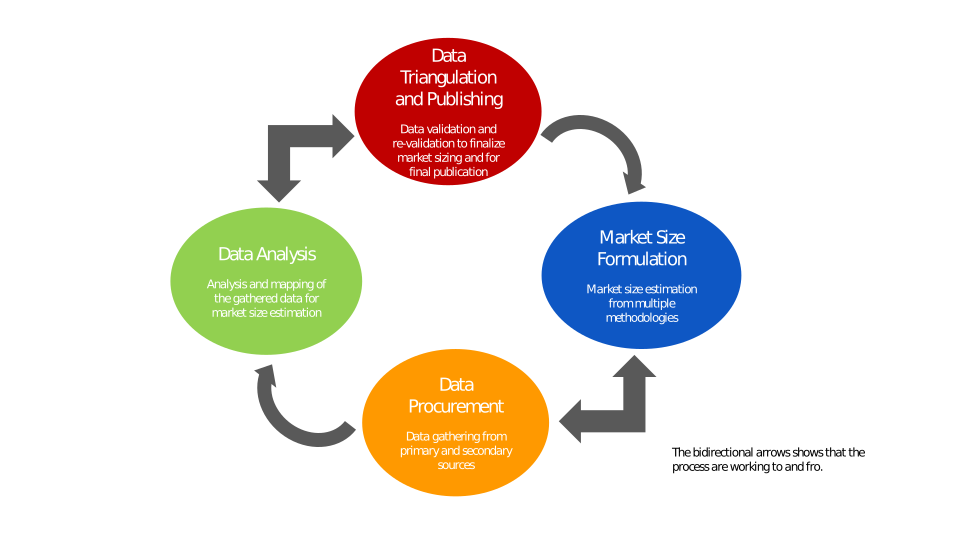
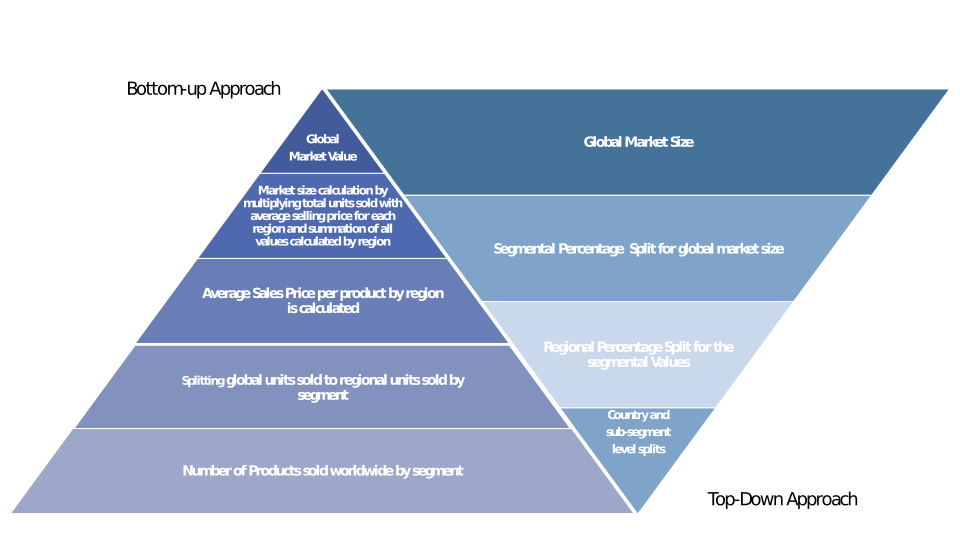
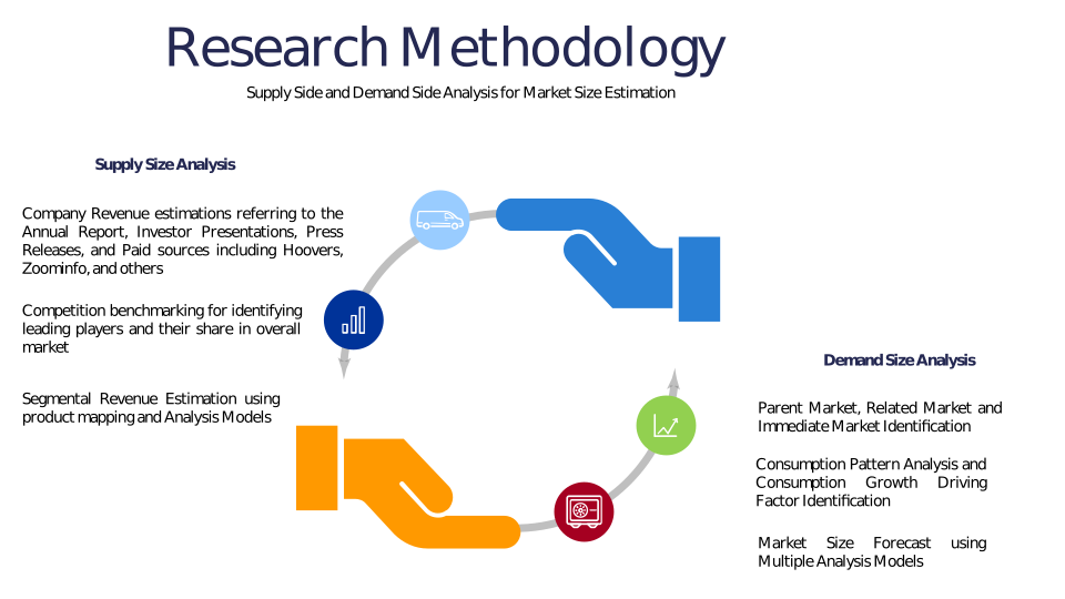
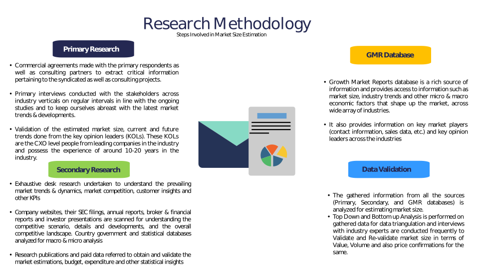
Chapter 3 Research Methodology
Chapter 4 Drone-Based Crop Canopy Height Model Market Overview
4.1 Introduction
4.1.1 Market Taxonomy
4.1.2 Market Definition
4.1.3 Macro-Economic Factors Impacting the Market Growth
4.2 Drone-Based Crop Canopy Height Model Market Dynamics
4.2.1 Market Drivers
4.2.2 Market Restraints
4.2.3 Market Opportunity
4.3 Drone-Based Crop Canopy Height Model Market - Supply Chain Analysis
4.3.1 List of Key Suppliers
4.3.2 List of Key Distributors
4.3.3 List of Key Consumers
4.4 Key Forces Shaping the Drone-Based Crop Canopy Height Model Market
4.4.1 Bargaining Power of Suppliers
4.4.2 Bargaining Power of Buyers
4.4.3 Threat of Substitution
4.4.4 Threat of New Entrants
4.4.5 Competitive Rivalry
4.5 Global Drone-Based Crop Canopy Height Model Market Size & Forecast, 2023-2032
4.5.1 Drone-Based Crop Canopy Height Model Market Size and Y-o-Y Growth
4.5.2 Drone-Based Crop Canopy Height Model Market Absolute $ Opportunity
Chapter 5 Global Drone-Based Crop Canopy Height Model Market Analysis and Forecast By Component
5.1 Introduction
5.1.1 Key Market Trends & Growth Opportunities By Component
5.1.2 Basis Point Share (BPS) Analysis By Component
5.1.3 Absolute $ Opportunity Assessment By Component
5.2 Drone-Based Crop Canopy Height Model Market Size Forecast By Component
5.2.1 Hardware
5.2.2 Software
5.2.3 Services
5.3 Market Attractiveness Analysis By Component
Chapter 6 Global Drone-Based Crop Canopy Height Model Market Analysis and Forecast By Application
6.1 Introduction
6.1.1 Key Market Trends & Growth Opportunities By Application
6.1.2 Basis Point Share (BPS) Analysis By Application
6.1.3 Absolute $ Opportunity Assessment By Application
6.2 Drone-Based Crop Canopy Height Model Market Size Forecast By Application
6.2.1 Precision Agriculture
6.2.2 Crop Monitoring
6.2.3 Yield Estimation
6.2.4 Disease Detection
6.2.5 Others
6.3 Market Attractiveness Analysis By Application
Chapter 7 Global Drone-Based Crop Canopy Height Model Market Analysis and Forecast By Crop Type
7.1 Introduction
7.1.1 Key Market Trends & Growth Opportunities By Crop Type
7.1.2 Basis Point Share (BPS) Analysis By Crop Type
7.1.3 Absolute $ Opportunity Assessment By Crop Type
7.2 Drone-Based Crop Canopy Height Model Market Size Forecast By Crop Type
7.2.1 Cereals & Grains
7.2.2 Fruits & Vegetables
7.2.3 Oilseeds & Pulses
7.2.4 Others
7.3 Market Attractiveness Analysis By Crop Type
Chapter 8 Global Drone-Based Crop Canopy Height Model Market Analysis and Forecast By End-User
8.1 Introduction
8.1.1 Key Market Trends & Growth Opportunities By End-User
8.1.2 Basis Point Share (BPS) Analysis By End-User
8.1.3 Absolute $ Opportunity Assessment By End-User
8.2 Drone-Based Crop Canopy Height Model Market Size Forecast By End-User
8.2.1 Agricultural Enterprises
8.2.2 Research Institutes
8.2.3 Government & Regulatory Bodies
8.2.4 Others
8.3 Market Attractiveness Analysis By End-User
Chapter 9 Global Drone-Based Crop Canopy Height Model Market Analysis and Forecast by Region
9.1 Introduction
9.1.1 Key Market Trends & Growth Opportunities By Region
9.1.2 Basis Point Share (BPS) Analysis By Region
9.1.3 Absolute $ Opportunity Assessment By Region
9.2 Drone-Based Crop Canopy Height Model Market Size Forecast By Region
9.2.1 North America
9.2.2 Europe
9.2.3 Asia Pacific
9.2.4 Latin America
9.2.5 Middle East & Africa (MEA)
9.3 Market Attractiveness Analysis By Region
Chapter 10 Coronavirus Disease (COVID-19) Impact
10.1 Introduction
10.2 Current & Future Impact Analysis
10.3 Economic Impact Analysis
10.4 Government Policies
10.5 Investment Scenario
Chapter 11 North America Drone-Based Crop Canopy Height Model Analysis and Forecast
11.1 Introduction
11.2 North America Drone-Based Crop Canopy Height Model Market Size Forecast by Country
11.2.1 U.S.
11.2.2 Canada
11.3 Basis Point Share (BPS) Analysis by Country
11.4 Absolute $ Opportunity Assessment by Country
11.5 Market Attractiveness Analysis by Country
11.6 North America Drone-Based Crop Canopy Height Model Market Size Forecast By Component
11.6.1 Hardware
11.6.2 Software
11.6.3 Services
11.7 Basis Point Share (BPS) Analysis By Component
11.8 Absolute $ Opportunity Assessment By Component
11.9 Market Attractiveness Analysis By Component
11.10 North America Drone-Based Crop Canopy Height Model Market Size Forecast By Application
11.10.1 Precision Agriculture
11.10.2 Crop Monitoring
11.10.3 Yield Estimation
11.10.4 Disease Detection
11.10.5 Others
11.11 Basis Point Share (BPS) Analysis By Application
11.12 Absolute $ Opportunity Assessment By Application
11.13 Market Attractiveness Analysis By Application
11.14 North America Drone-Based Crop Canopy Height Model Market Size Forecast By Crop Type
11.14.1 Cereals & Grains
11.14.2 Fruits & Vegetables
11.14.3 Oilseeds & Pulses
11.14.4 Others
11.15 Basis Point Share (BPS) Analysis By Crop Type
11.16 Absolute $ Opportunity Assessment By Crop Type
11.17 Market Attractiveness Analysis By Crop Type
11.18 North America Drone-Based Crop Canopy Height Model Market Size Forecast By End-User
11.18.1 Agricultural Enterprises
11.18.2 Research Institutes
11.18.3 Government & Regulatory Bodies
11.18.4 Others
11.19 Basis Point Share (BPS) Analysis By End-User
11.20 Absolute $ Opportunity Assessment By End-User
11.21 Market Attractiveness Analysis By End-User
Chapter 12 Europe Drone-Based Crop Canopy Height Model Analysis and Forecast
12.1 Introduction
12.2 Europe Drone-Based Crop Canopy Height Model Market Size Forecast by Country
12.2.1 Germany
12.2.2 France
12.2.3 Italy
12.2.4 U.K.
12.2.5 Spain
12.2.6 Russia
12.2.7 Rest of Europe
12.3 Basis Point Share (BPS) Analysis by Country
12.4 Absolute $ Opportunity Assessment by Country
12.5 Market Attractiveness Analysis by Country
12.6 Europe Drone-Based Crop Canopy Height Model Market Size Forecast By Component
12.6.1 Hardware
12.6.2 Software
12.6.3 Services
12.7 Basis Point Share (BPS) Analysis By Component
12.8 Absolute $ Opportunity Assessment By Component
12.9 Market Attractiveness Analysis By Component
12.10 Europe Drone-Based Crop Canopy Height Model Market Size Forecast By Application
12.10.1 Precision Agriculture
12.10.2 Crop Monitoring
12.10.3 Yield Estimation
12.10.4 Disease Detection
12.10.5 Others
12.11 Basis Point Share (BPS) Analysis By Application
12.12 Absolute $ Opportunity Assessment By Application
12.13 Market Attractiveness Analysis By Application
12.14 Europe Drone-Based Crop Canopy Height Model Market Size Forecast By Crop Type
12.14.1 Cereals & Grains
12.14.2 Fruits & Vegetables
12.14.3 Oilseeds & Pulses
12.14.4 Others
12.15 Basis Point Share (BPS) Analysis By Crop Type
12.16 Absolute $ Opportunity Assessment By Crop Type
12.17 Market Attractiveness Analysis By Crop Type
12.18 Europe Drone-Based Crop Canopy Height Model Market Size Forecast By End-User
12.18.1 Agricultural Enterprises
12.18.2 Research Institutes
12.18.3 Government & Regulatory Bodies
12.18.4 Others
12.19 Basis Point Share (BPS) Analysis By End-User
12.20 Absolute $ Opportunity Assessment By End-User
12.21 Market Attractiveness Analysis By End-User
Chapter 13 Asia Pacific Drone-Based Crop Canopy Height Model Analysis and Forecast
13.1 Introduction
13.2 Asia Pacific Drone-Based Crop Canopy Height Model Market Size Forecast by Country
13.2.1 China
13.2.2 Japan
13.2.3 South Korea
13.2.4 India
13.2.5 Australia
13.2.6 South East Asia (SEA)
13.2.7 Rest of Asia Pacific (APAC)
13.3 Basis Point Share (BPS) Analysis by Country
13.4 Absolute $ Opportunity Assessment by Country
13.5 Market Attractiveness Analysis by Country
13.6 Asia Pacific Drone-Based Crop Canopy Height Model Market Size Forecast By Component
13.6.1 Hardware
13.6.2 Software
13.6.3 Services
13.7 Basis Point Share (BPS) Analysis By Component
13.8 Absolute $ Opportunity Assessment By Component
13.9 Market Attractiveness Analysis By Component
13.10 Asia Pacific Drone-Based Crop Canopy Height Model Market Size Forecast By Application
13.10.1 Precision Agriculture
13.10.2 Crop Monitoring
13.10.3 Yield Estimation
13.10.4 Disease Detection
13.10.5 Others
13.11 Basis Point Share (BPS) Analysis By Application
13.12 Absolute $ Opportunity Assessment By Application
13.13 Market Attractiveness Analysis By Application
13.14 Asia Pacific Drone-Based Crop Canopy Height Model Market Size Forecast By Crop Type
13.14.1 Cereals & Grains
13.14.2 Fruits & Vegetables
13.14.3 Oilseeds & Pulses
13.14.4 Others
13.15 Basis Point Share (BPS) Analysis By Crop Type
13.16 Absolute $ Opportunity Assessment By Crop Type
13.17 Market Attractiveness Analysis By Crop Type
13.18 Asia Pacific Drone-Based Crop Canopy Height Model Market Size Forecast By End-User
13.18.1 Agricultural Enterprises
13.18.2 Research Institutes
13.18.3 Government & Regulatory Bodies
13.18.4 Others
13.19 Basis Point Share (BPS) Analysis By End-User
13.20 Absolute $ Opportunity Assessment By End-User
13.21 Market Attractiveness Analysis By End-User
Chapter 14 Latin America Drone-Based Crop Canopy Height Model Analysis and Forecast
14.1 Introduction
14.2 Latin America Drone-Based Crop Canopy Height Model Market Size Forecast by Country
14.2.1 Brazil
14.2.2 Mexico
14.2.3 Rest of Latin America (LATAM)
14.3 Basis Point Share (BPS) Analysis by Country
14.4 Absolute $ Opportunity Assessment by Country
14.5 Market Attractiveness Analysis by Country
14.6 Latin America Drone-Based Crop Canopy Height Model Market Size Forecast By Component
14.6.1 Hardware
14.6.2 Software
14.6.3 Services
14.7 Basis Point Share (BPS) Analysis By Component
14.8 Absolute $ Opportunity Assessment By Component
14.9 Market Attractiveness Analysis By Component
14.10 Latin America Drone-Based Crop Canopy Height Model Market Size Forecast By Application
14.10.1 Precision Agriculture
14.10.2 Crop Monitoring
14.10.3 Yield Estimation
14.10.4 Disease Detection
14.10.5 Others
14.11 Basis Point Share (BPS) Analysis By Application
14.12 Absolute $ Opportunity Assessment By Application
14.13 Market Attractiveness Analysis By Application
14.14 Latin America Drone-Based Crop Canopy Height Model Market Size Forecast By Crop Type
14.14.1 Cereals & Grains
14.14.2 Fruits & Vegetables
14.14.3 Oilseeds & Pulses
14.14.4 Others
14.15 Basis Point Share (BPS) Analysis By Crop Type
14.16 Absolute $ Opportunity Assessment By Crop Type
14.17 Market Attractiveness Analysis By Crop Type
14.18 Latin America Drone-Based Crop Canopy Height Model Market Size Forecast By End-User
14.18.1 Agricultural Enterprises
14.18.2 Research Institutes
14.18.3 Government & Regulatory Bodies
14.18.4 Others
14.19 Basis Point Share (BPS) Analysis By End-User
14.20 Absolute $ Opportunity Assessment By End-User
14.21 Market Attractiveness Analysis By End-User
Chapter 15 Middle East & Africa (MEA) Drone-Based Crop Canopy Height Model Analysis and Forecast
15.1 Introduction
15.2 Middle East & Africa (MEA) Drone-Based Crop Canopy Height Model Market Size Forecast by Country
15.2.1 Saudi Arabia
15.2.2 South Africa
15.2.3 UAE
15.2.4 Rest of Middle East & Africa (MEA)
15.3 Basis Point Share (BPS) Analysis by Country
15.4 Absolute $ Opportunity Assessment by Country
15.5 Market Attractiveness Analysis by Country
15.6 Middle East & Africa (MEA) Drone-Based Crop Canopy Height Model Market Size Forecast By Component
15.6.1 Hardware
15.6.2 Software
15.6.3 Services
15.7 Basis Point Share (BPS) Analysis By Component
15.8 Absolute $ Opportunity Assessment By Component
15.9 Market Attractiveness Analysis By Component
15.10 Middle East & Africa (MEA) Drone-Based Crop Canopy Height Model Market Size Forecast By Application
15.10.1 Precision Agriculture
15.10.2 Crop Monitoring
15.10.3 Yield Estimation
15.10.4 Disease Detection
15.10.5 Others
15.11 Basis Point Share (BPS) Analysis By Application
15.12 Absolute $ Opportunity Assessment By Application
15.13 Market Attractiveness Analysis By Application
15.14 Middle East & Africa (MEA) Drone-Based Crop Canopy Height Model Market Size Forecast By Crop Type
15.14.1 Cereals & Grains
15.14.2 Fruits & Vegetables
15.14.3 Oilseeds & Pulses
15.14.4 Others
15.15 Basis Point Share (BPS) Analysis By Crop Type
15.16 Absolute $ Opportunity Assessment By Crop Type
15.17 Market Attractiveness Analysis By Crop Type
15.18 Middle East & Africa (MEA) Drone-Based Crop Canopy Height Model Market Size Forecast By End-User
15.18.1 Agricultural Enterprises
15.18.2 Research Institutes
15.18.3 Government & Regulatory Bodies
15.18.4 Others
15.19 Basis Point Share (BPS) Analysis By End-User
15.20 Absolute $ Opportunity Assessment By End-User
15.21 Market Attractiveness Analysis By End-User
Chapter 16 Competition Landscape
16.1 Drone-Based Crop Canopy Height Model Market: Competitive Dashboard
16.2 Global Drone-Based Crop Canopy Height Model Market: Market Share Analysis, 2023
16.3 Company Profiles (Details – Overview, Financials, Developments, Strategy)
16.3.1 DJI
16.3.2 Parrot SA
16.3.3 AgEagle Aerial Systems
16.3.4 senseFly (a Parrot Company)
16.3.5 Trimble Inc.
16.3.6 AeroVironment, Inc.
16.3.7 Delair
16.3.8 Sentera
16.3.9 DroneDeploy
16.3.10 Pix4D
16.3.11 MicaSense (a TeledyneFLIR company)
16.3.12 Yamaha Motor Corporation
16.3.13 Terra Drone Corporation
16.3.14 Quantum Systems
16.3.15 Agremo
16.3.16 Skycatch
16.3.17 Wingtra
16.3.18 Autel Robotics
16.3.19 XAG Co. Ltd.
16.3.20 Precision AI
Methodology
Related Reports
Some other reports from this category!





Our Clients