Drone-Based Coral Bleaching Survey Market Size, Share & Growth Analysis, 2026-2034
Drone-Based Coral Bleaching Survey Market Size, Share & Growth Analysis, 2026-2034
Segments - by Drone Type (Fixed-Wing, Rotary-Wing, Hybrid), by Application (Coral Reef Monitoring, Environmental Impact Assessment, Research and Development, Conservation Initiatives, Others), by Sensor Type (RGB Cameras, Multispectral Sensors, Thermal Sensors, LiDAR, Others), by End-User (Research Institutes, Government Agencies, Environmental NGOs, Aquariums and Marine Parks, Others)



Last Updated : Jun, 2026
| Report ID :AD-11507
| 4.7 Rating
| 92 Reviews
| 299 Pages
| Format :


Drone-Based Coral Bleaching Survey Market: Key Numbers
The Drone-Based Coral Bleaching Survey market was valued at USD 218.9 Million in 2025 and is projected to reach USD 681.4 Million by 2034, a CAGR of 13.5%.
| Market size (2025) | USD 218.9 Million |
|---|---|
| Forecast (2034) | USD 681.4 Million |
| CAGR (2026-2034) | 13.5% |
| Largest region | Asia Pacific |
| Segments covered | Drone Type, Application, Sensor Type, End-User |
| Key companies | DJI (SZ DJI Technology Co. Ltd.), Parrot SA, AeroVironment Inc., AgEagle Aerial Systems (senseFly), Quantum-Systems GmbH |
This report is updated with the latest market data and insights as of June 2026. Base year: 2025 | Forecast period: 2026-2034
Drone-Based Coral Bleaching Survey Market Size and Growth Outlook
The drone-based coral bleaching survey market size reached USD 218.9 million globally in 2025, demonstrating significant momentum driven by technological advancements and the urgent need for marine ecosystem monitoring. The market is projected to grow at a robust CAGR of 13.5% during the forecast period, reaching an estimated USD 681.4 million by 2034. The primary growth factor fueling this expansion is the increasing prevalence of coral bleaching events worldwide, which has heightened the demand for efficient, scalable, and cost-effective survey solutions capable of operating across diverse and remote reef environments.

The growth trajectory of the drone-based coral bleaching survey market is powered by the convergence of environmental necessity and technological innovation. With coral reefs facing unprecedented threats from rising sea temperatures, ocean acidification, and pollution, the demand for real-time, high-resolution monitoring solutions has surged through 2025 and is expected to intensify across the 2026-2034 forecast window. Drones equipped with advanced sensors offer unparalleled access to remote and delicate reef environments, enabling researchers and conservationists to collect precise data with minimal ecological disturbance. Furthermore, the integration of artificial intelligence and machine learning algorithms with drone imagery has significantly enhanced the accuracy and efficiency of coral health assessments, driving wider adoption across research institutes, government agencies, and environmental NGOs. Broader ecosystem surveillance programs, including drone-based coral reef monitoring initiatives, are increasingly complementing bleaching-specific survey efforts to deliver holistic reef management data.
Another critical growth factor is the escalating support from government bodies and international organizations for marine conservation initiatives. Numerous countries have launched strategic programs to protect and restore coral reefs, allocating substantial funding for advanced monitoring technologies such as drone-based surveys. This institutional backing not only accelerates the deployment of drones in marine research but also fosters collaborations between public and private sector stakeholders. The market has also benefited from regulatory reforms that facilitate drone operations in marine protected areas, further expanding the potential user base and application scope of drone-based coral bleaching surveys.
The market's expansion is also underpinned by growing public awareness and advocacy for ocean health. As the general population becomes increasingly informed about the ecological and economic importance of coral reefs, there is a rising demand for transparent and accessible reef monitoring data. Drones, with their ability to capture and disseminate compelling visual evidence of reef conditions, play a vital role in public engagement and policy advocacy. This societal shift has encouraged environmental NGOs and aquariums to invest in drone-based monitoring, not only for research but also for educational outreach and conservation campaigns. Parallel advances in drone-assisted coral planting are further reinforcing the role of unmanned systems across the full coral reef restoration lifecycle, from health assessment to active reef rebuilding.
In addition to coral bleaching surveys, Drone-Based High-Resolution Coastal Mapping is gaining traction as a vital tool for coastal management and conservation. This technology allows for the detailed mapping of coastal areas, capturing data on shoreline changes, erosion patterns, and habitat distribution. By providing high-resolution imagery and topographical data, drones enable researchers and policymakers to make informed decisions about coastal development and conservation efforts. The integration of drone-based mapping with geographic information systems (GIS) further enhances its utility, allowing for the creation of comprehensive coastal management plans that address both environmental and socio-economic concerns. This approach is particularly valuable in regions facing the dual challenges of climate change and rapid urbanization, where effective coastal management is crucial for sustainable development.
Regionally, the Asia Pacific segment commands the largest share of the drone-based coral bleaching survey market, owing to the region's extensive coral reef systems and heightened vulnerability to climate-induced bleaching events. Countries such as Australia, Indonesia, and the Philippines are at the forefront of adopting drone technologies for coral monitoring, supported by robust research infrastructure and proactive government initiatives. North America and Europe also exhibit strong growth potential, driven by technological innovation and increasing investments in marine conservation. Meanwhile, emerging markets in Latin America, the Middle East, and Africa are gradually recognizing the value of drone-based surveys, although growth in these regions is somewhat constrained by regulatory and infrastructural challenges.
Drone-Based Coral Bleaching Survey Market by Drone Type
The drone type segment within the drone-based coral bleaching survey market is categorized into fixed-wing, rotary-wing, and hybrid drones, each offering distinct advantages and operational capabilities. Fixed-wing drones are particularly valued for their extended flight endurance and ability to cover vast reef areas in a single sortie, making them ideal for large-scale coral reef monitoring and environmental impact assessments. These drones are typically deployed in open-ocean surveys where efficiency and coverage are paramount, and their use is prevalent among government agencies and research institutes tasked with monitoring expansive marine reserves. However, their operational complexity and higher upfront costs can pose barriers to adoption among smaller organizations and NGOs. Fixed-wing platforms holding approximately 31.2% of the drone type segment in 2025 remain a cornerstone of regional-scale bleaching assessment programs.

Rotary-wing drones, commanding the largest segment share at roughly 47.6% of drone type revenues in 2025, are highly maneuverable and can hover in place, making them exceptionally suited for detailed, close-range inspections of coral reefs. Their versatility allows for precise data capture in complex and shallow reef environments where fixed-wing drones may be less effective. Rotary-wing drones are extensively used in conservation initiatives that require frequent site visits and real-time decision-making, such as targeted restoration projects and localized bleaching assessments. The ongoing advancements in battery technology and flight stability have further enhanced their operational lifespan and reliability, contributing to their growing popularity across all end-user segments. Scientists conducting reef fish population surveys alongside bleaching assessments frequently rely on the same rotary-wing platforms, improving cost efficiency for multi-objective field campaigns.
The emergence of hybrid drones, accounting for approximately 21.2% of the segment in 2025, represents a significant technological leap in the market. By combining the endurance of fixed-wing models with the vertical takeoff and landing (VTOL) capabilities of rotary-wing drones, hybrid systems offer unparalleled flexibility for coral bleaching surveys. These drones can efficiently transition between large-area mapping and close-up inspections within a single mission, optimizing both resource utilization and data quality. Hybrid drones are increasingly being adopted by research institutions and environmental NGOs seeking to maximize survey coverage without compromising on data granularity, and their adoption is expected to rise steadily as the technology matures and costs decrease through 2034.
The choice of drone type is influenced by several factors, including survey objectives, geographic location, and budget constraints. While fixed-wing drones are favored for their range and efficiency in large-scale monitoring, rotary-wing and hybrid drones are gaining traction for their adaptability and ease of deployment in diverse reef environments. The market is witnessing a trend towards multi-drone fleets, where organizations deploy a combination of drone types to address different survey requirements. This approach not only enhances operational efficiency but also ensures comprehensive coverage of both broad and intricate reef areas, thereby improving the overall quality of coral bleaching assessments.
As drone technology continues to evolve, the future of the drone-based coral bleaching survey market will likely see further integration of advanced propulsion systems, autonomous navigation, and modular payloads tailored to specific survey needs. Manufacturers are increasingly focusing on developing lightweight, rugged drones capable of withstanding harsh marine conditions, while end-users are prioritizing platforms that offer scalability and interoperability with existing data management systems. The application of similar autonomous platform advances to sea turtle nest surveys demonstrates how hardware innovation in one marine monitoring domain rapidly benefits adjacent disciplines, accelerating cross-sector technology transfer. This dynamic interplay between technological innovation and user demand is set to shape the competitive landscape of the drone type segment in the coming years.
Drone-Based Coral Bleaching Survey Market Report Scope
| Attributes | Details |
| Report Title | Drone-Based Coral Bleaching Survey Market Research Report 2034 |
| By Drone Type | Fixed-Wing, Rotary-Wing, Hybrid |
| By Application | Coral Reef Monitoring, Environmental Impact Assessment, Research and Development, Conservation Initiatives, Others |
| By Sensor Type | RGB Cameras, Multispectral Sensors, Thermal Sensors, LiDAR, Others |
| By End-User | Research Institutes, Government Agencies, Environmental NGOs, Aquariums and Marine Parks, Others |
| Regions Covered | North America, Europe, APAC, Latin America, MEA |
| Base Year | 2025 |
| Historic Data | 2019-2024 |
| Forecast Period | 2026-2034 |
| Number of Pages | 299 |
| Number of Tables & Figures | 364 |
| Customization Available | Yes, the report can be customized as per your need. |
Drone-Based Coral Bleaching Survey Market by Application
The application segment of the drone-based coral bleaching survey market encompasses coral reef monitoring, environmental impact assessment, research and development, conservation initiatives, and other specialized uses. Coral reef monitoring remains the dominant application, accounting for the largest share of market revenue in 2025. Drones have revolutionized the way scientists and conservationists monitor reef health, enabling high-frequency, repeatable surveys that provide critical insights into bleaching patterns, recovery rates, and the effectiveness of restoration efforts. The ability to generate georeferenced, high-resolution imagery in near real-time is a game-changer for long-term reef monitoring programs, particularly in regions where traditional survey methods are logistically challenging or prohibitively expensive.
Environmental impact assessment is another key application area, driven by the growing regulatory requirements for marine infrastructure projects such as coastal development, dredging, and tourism operations. Drones offer a cost-effective and minimally invasive means of assessing the potential impacts of human activities on coral reefs, providing decision-makers with robust data to inform mitigation strategies and compliance monitoring. The rapid deployment and scalability of drone-based surveys make them particularly attractive for baseline studies and post-project evaluations, ensuring that environmental standards are upheld while minimizing project delays.
In the domain of research and development, drones are enabling a new wave of scientific discovery and innovation in 2025 and beyond. Researchers are leveraging drone-acquired data to develop predictive models of coral bleaching, investigate the underlying causes of reef decline, and test novel restoration techniques. The integration of drone imagery with other data sources, such as satellite observations and in-situ measurements, is facilitating a more holistic understanding of reef ecosystems and their responses to environmental stressors. This interdisciplinary approach is fostering collaborations between marine biologists, data scientists, and engineers, further expanding the scope and impact of drone-based surveys in R&D settings. The methodologies developed for aerial reef surveys are also informing broader drone-enabled wildlife survey frameworks, creating shared best practices across marine and terrestrial ecosystems.
Conservation initiatives represent a rapidly growing application segment, as NGOs and community organizations harness drone technology to support reef restoration, advocacy, and public engagement efforts. Drones are being used to document the progress of coral planting projects, monitor illegal fishing activities, and raise awareness about the plight of coral reefs through compelling visual storytelling. The accessibility and user-friendliness of modern drone platforms have lowered the barriers to entry for grassroots organizations, democratizing access to high-quality reef monitoring tools and empowering local communities to take an active role in conservation.
Beyond these primary applications, drones are also being utilized for specialized purposes such as educational outreach, marine spatial planning, and disaster response. The versatility and adaptability of drone-based survey systems ensure that they can be tailored to meet the unique needs of diverse stakeholders, from policymakers and educators to tourism operators and indigenous communities. As new use cases continue to emerge through the 2026-2034 forecast period, the application landscape of the drone-based coral bleaching survey market is expected to diversify further, driving sustained growth and innovation.
Drone-Based Coral Bleaching Survey Market by Sensor Type
The sensor type segment is a critical determinant of the effectiveness and versatility of drone-based coral bleaching surveys. RGB cameras are the most widely used sensors, offering high-resolution visual imagery that is essential for identifying bleaching events, mapping reef structures, and documenting changes over time. These cameras are valued for their affordability, ease of integration, and compatibility with a wide range of drone platforms, making them the sensor of choice for many entry-level and mid-tier survey applications. However, while RGB imagery provides valuable visual information, it may be limited in its ability to detect subtle physiological changes in corals or differentiate between healthy and stressed colonies.
Multispectral sensors have emerged as a powerful tool for enhancing the precision and depth of coral health assessments in 2025. By capturing data across multiple wavelengths, these sensors can detect variations in coral pigmentation and tissue health that are invisible to the naked eye. Multispectral imaging enables researchers to quantify the extent and severity of bleaching, monitor the recovery process, and identify early warning signs of stress. The adoption of multispectral sensors is being driven by advancements in sensor miniaturization and data processing, which have made these technologies more accessible and cost-effective for a broader range of users. The same spectral analysis principles are being applied in wetland biodiversity surveys, reflecting the cross-ecosystem value of multispectral drone technology.
Thermal sensors play a pivotal role in understanding the thermal dynamics of reef environments and their influence on coral bleaching. By measuring surface water temperatures with high spatial resolution, thermal sensors help researchers identify hotspots of thermal stress and correlate temperature anomalies with observed bleaching patterns. This capability is particularly valuable in the context of climate change, as rising sea temperatures are the primary driver of mass bleaching events. The integration of thermal data with visual and multispectral imagery enables a more comprehensive assessment of reef health and resilience, supporting targeted management interventions.
LiDAR (Light Detection and Ranging) technology is gaining traction in the market for its ability to generate detailed three-dimensional maps of reef topography and bathymetry. LiDAR-equipped drones can capture precise elevation data, enabling the creation of digital elevation models that support habitat mapping, erosion monitoring, and restoration planning. While LiDAR systems are typically more expensive and complex than other sensor types, their unique capabilities make them indispensable for advanced research and large-scale monitoring projects. The adoption of LiDAR is expected to increase as costs decline and integration with other sensor modalities becomes more seamless across the 2026-2034 forecast period.
In addition to these primary sensor types, the market is witnessing the emergence of specialized sensors such as hyperspectral cameras, water quality sensors, and acoustic sensors, which further expand the analytical capabilities of drone-based surveys. The ongoing convergence of sensor technologies is enabling multi-modal data acquisition, where drones simultaneously capture visual, spectral, thermal, and topographic information in a single flight. This holistic approach not only improves the accuracy and reliability of coral bleaching assessments but also supports a wider range of scientific and conservation objectives, positioning sensor innovation as a key driver of market growth through 2034.
Drone-Based Coral Bleaching Survey Market by End-User
The end-user segment of the drone-based coral bleaching survey market is diverse, encompassing research institutes, government agencies, environmental NGOs, aquariums and marine parks, and other stakeholders. Research institutes represent the largest end-user group, leveraging drone technology to conduct fundamental and applied research on coral reef ecosystems. These organizations require robust, high-precision survey tools to support long-term monitoring programs, experimental studies, and the development of predictive models. The collaborative nature of academic research often leads to partnerships with technology providers and other stakeholders, fostering innovation and driving the adoption of cutting-edge drone solutions.
Government agencies play a pivotal role in the market, particularly in regions where coral reefs are recognized as critical natural resources. These agencies are responsible for implementing marine conservation policies, enforcing environmental regulations, and responding to bleaching events. Drones enable government bodies to conduct rapid, large-scale assessments of reef health, allocate resources more efficiently, and engage with local communities through transparent data sharing. The increasing availability of public funding for drone-based monitoring initiatives is expected to further stimulate market growth through 2034, particularly in countries with extensive reef systems and strong conservation mandates.
Environmental NGOs are at the forefront of grassroots conservation efforts, utilizing drone technology to support advocacy, restoration, and community engagement activities. These organizations often operate with limited resources and require cost-effective, user-friendly survey solutions that can be deployed by non-specialist personnel. The democratization of drone technology has empowered NGOs to scale their monitoring efforts, document the impacts of climate change, and mobilize public support for reef protection. Partnerships between NGOs, research institutes, and government agencies are increasingly common, enabling the pooling of resources and expertise to achieve shared conservation objectives.
Aquariums and marine parks constitute a growing end-user segment, driven by the dual imperatives of research and public education. These institutions use drone-based surveys to monitor the health of in-situ and ex-situ coral populations, inform exhibit design, and develop educational programs that raise awareness about the importance of reef ecosystems. The visual appeal and accessibility of drone imagery make it an effective tool for engaging visitors and stakeholders, supporting fundraising and outreach initiatives. As public interest in marine conservation continues to grow through 2025 and beyond, aquariums and marine parks are expected to play an increasingly prominent role in the adoption and dissemination of drone-based monitoring technologies.
Other end-users, including tourism operators, indigenous communities, and private sector stakeholders, are also recognizing the value of drone-based coral bleaching surveys. These groups utilize drones to support sustainable tourism, manage reef-based resources, and fulfill corporate social responsibility commitments. The expanding diversity of end-users underscores the broad applicability and market potential of drone-based survey solutions, as well as the importance of developing flexible, scalable platforms that can meet the unique needs of different stakeholders.
Drone-Based Coral Bleaching Survey Market Opportunities and Threats
The drone-based coral bleaching survey market is ripe with opportunities, driven by the growing convergence of environmental urgency and technological innovation. One of the most significant opportunities lies in the integration of artificial intelligence and machine learning with drone-acquired data. Advanced analytics can automate the identification and quantification of bleaching events, reducing the need for manual interpretation and enabling real-time decision-making. This technological leap not only improves the accuracy and efficiency of surveys but also opens up new possibilities for large-scale, automated reef monitoring programs. The development of user-friendly data platforms and visualization tools further enhances the accessibility and impact of drone-based surveys, empowering a wider range of stakeholders to participate in reef conservation efforts through 2034.
Another promising opportunity is the expansion of public-private partnerships and cross-sector collaborations. As the complexity and scale of coral bleaching challenges increase, there is a growing recognition that effective solutions require coordinated action across scientific, governmental, and civil society domains. Partnerships between drone manufacturers, research institutions, NGOs, and government agencies can accelerate the development and deployment of innovative survey technologies, facilitate knowledge sharing, and mobilize resources for large-scale monitoring and restoration initiatives. The increasing availability of funding from international organizations and philanthropic foundations further supports the growth of collaborative projects, driving market expansion and impact across the 2026-2034 forecast period.
Despite these opportunities, the market faces several restraining factors that could impede growth. One of the primary challenges is the regulatory environment governing drone operations, particularly in marine protected areas and sensitive ecological zones. Stringent regulations, complex permitting processes, and restrictions on drone flights can limit the deployment of survey missions, especially for smaller organizations with limited resources. Additionally, concerns about data privacy, security, and the potential for ecological disturbance may lead to increased scrutiny and regulatory oversight. Addressing these challenges will require ongoing engagement with policymakers, the development of best practice guidelines, and the promotion of responsible drone use to ensure that the benefits of drone-based coral bleaching surveys are realized without compromising environmental integrity.
Drone-Based Coral Bleaching Survey Market Size by Region
The Asia Pacific region dominates the drone-based coral bleaching survey market, accounting for approximately 38.5% of global revenue in 2025. This leadership position is underpinned by the region's vast coral reef systems, including the Great Barrier Reef in Australia, the Coral Triangle in Southeast Asia, and extensive reef networks in the Philippines and Indonesia. Governments in these countries have prioritized reef conservation, investing heavily in advanced monitoring technologies and fostering collaborations between research institutions, NGOs, and technology providers. The Asia Pacific market is expected to maintain a strong growth trajectory, with a projected CAGR of 14.8% through 2034, driven by ongoing environmental challenges and robust policy support.

North America and Europe are also significant contributors to the global market, with a combined share of approximately 41.7% in 2025. In North America, the United States leads market growth, supported by a strong ecosystem of research institutions, government agencies, and private sector innovators. The region's focus on technological advancement and environmental stewardship has fueled the adoption of drone-based survey solutions, particularly in Florida, Hawaii, and the Caribbean territories. In Europe, countries such as the United Kingdom, France, and Spain are actively investing in marine conservation and leveraging drone technologies to monitor and protect their coastal and overseas reef assets. Both regions are expected to experience steady growth supported by favorable regulatory environments and increasing public awareness of marine conservation issues.
Emerging markets in Latin America and the Middle East & Africa are gradually recognizing the value of drone-based coral bleaching surveys, with a combined market share of approximately 19.8% in 2025. These regions face unique challenges, including limited research infrastructure, regulatory hurdles, and varying levels of public and institutional support for reef conservation. However, targeted investments, capacity-building initiatives, and international collaborations are beginning to drive market penetration and adoption. As awareness of coral bleaching and its ecological and economic impacts grows, these regions are expected to play an increasingly important role in the global market landscape through 2034, particularly as drone technology becomes more accessible and affordable.
Drone-Based Coral Bleaching Survey Market Competitive Landscape
The competitive landscape of the drone-based coral bleaching survey market is characterized by a dynamic mix of established technology providers, specialized drone manufacturers, sensor developers, and service-oriented firms. Major players are continually investing in research and development to enhance the capabilities, reliability, and affordability of their drone platforms, with a particular focus on sensor integration, autonomous navigation, and data analytics. The market is also witnessing the emergence of niche players that offer tailored solutions for specific applications, such as multispectral imaging, thermal mapping, or LiDAR-based topographic surveys. This diversity of offerings has fostered a highly competitive environment, with companies vying to differentiate themselves through innovation, customer support, and value-added services as the market moves through the 2026-2034 forecast period.
Strategic partnerships and collaborations are a hallmark of the competitive landscape, as companies seek to leverage complementary strengths and expand their market reach. Drone manufacturers are increasingly partnering with sensor developers, software providers, and research institutions to deliver end-to-end solutions that address the full spectrum of user needs, from data acquisition to analysis and reporting. These alliances not only accelerate the pace of innovation but also enhance the scalability and interoperability of drone-based survey systems, enabling organizations to tackle complex, multi-faceted coral bleaching challenges more effectively.
The market is also characterized by a strong focus on customer education and support, as end-users increasingly demand turnkey solutions that are easy to deploy and operate. Leading companies are investing in training programs, technical support services, and user-friendly software platforms to lower the barriers to adoption and ensure successful project outcomes. The emphasis on customer-centricity is particularly important in the NGO and community sectors, where users may have limited technical expertise or resources. By providing comprehensive support throughout the project lifecycle, market leaders are building long-term relationships and driving repeat business across their global customer bases.
In terms of major companies, the market features prominent names such as DJI (SZ DJI Technology Co. Ltd.), Parrot SA, AgEagle Aerial Systems (senseFly), Quantum-Systems GmbH, and Delair SAS. DJI is widely recognized for its comprehensive range of rotary-wing and hybrid drones, which are extensively used in coral reef monitoring and research applications. The company's emphasis on sensor integration and user-friendly design has made its platforms a popular choice among NGOs and research institutes worldwide. Parrot SA specializes in multispectral and thermal imaging solutions, offering drones tailored for environmental monitoring and precision mapping. AgEagle Aerial Systems (senseFly) and Quantum-Systems GmbH are known for their fixed-wing and hybrid drone platforms, which are favored for large-scale, long-endurance survey missions. Delair SAS has carved out a niche in the market with its focus on data analytics and cloud-based processing, providing end-users with actionable insights and streamlined workflows.
Other notable players include Teledyne FLIR LLC, renowned for its advanced thermal sensors that are integral to sea surface temperature monitoring in bleaching assessments, and MicaSense Inc., a leader in multispectral imaging technology for environmental applications. Wingtra AG offers high-precision VTOL drones favored for scientific-grade mapping, while Skydio Inc. brings cutting-edge autonomous flight intelligence to the market. AeroVironment Inc. and Insitu Inc. (a Boeing company) provide robust platforms suited to government-agency and defense-adjacent conservation monitoring programs. Trimble Inc. and Terra Drone Corporation round out the competitive field with strong positioning in survey-grade data processing and regional drone service operations, respectively. As the market continues to evolve through 2034, ongoing investment in R&D, strategic partnerships, and customer engagement will be key differentiators for success in the dynamic and rapidly growing drone-based coral bleaching survey market.
Top Companies in the Drone-Based Coral Bleaching Survey Market
- DJI (SZ DJI Technology Co. Ltd.)
- Parrot SA
- AgEagle Aerial Systems (senseFly)
- Quantum-Systems GmbH
- Delair SAS
- Teledyne FLIR LLC
- MicaSense Inc.
- Wingtra AG
- Autel Robotics
- Skydio Inc.
- AeroVironment Inc.
- Terra Drone Corporation
- Trimble Inc.
- Insitu Inc. (a Boeing company)
- Swift Navigation
Segments
The Drone-Based Coral Bleaching Survey market has been segmented on the basis of
Drone Type
- Fixed-Wing
- Rotary-Wing
- Hybrid
Application
- Coral Reef Monitoring
- Environmental Impact Assessment
- Research and Development
- Conservation Initiatives
- Others
Sensor Type
- RGB Cameras
- Multispectral Sensors
- Thermal Sensors
- LiDAR
- Others
End-User
- Research Institutes
- Government Agencies
- Environmental NGOs
- Aquariums and Marine Parks
- Others
Frequently Asked Questions
Technological advancements are fundamentally transforming the market across multiple dimensions. AI and deep learning algorithms now enable automated, near-real-time identification and quantification of bleaching extent from drone imagery, dramatically reducing manual workload. Next-generation multispectral and hyperspectral sensors provide unprecedented detail on coral pigmentation and physiological stress. Advances in battery technology and hybrid propulsion extend mission endurance and operational range. Cloud-based data platforms and digital twin frameworks are enabling continuous, long-term reef monitoring at ecosystem scale. Swarm drone technologies, where multiple autonomous drones conduct coordinated surveys, are emerging as a transformative capability for large reef systems, promising to redefine the efficiency and coverage of coral health assessments through 2034 and beyond.
Leading companies include DJI (SZ DJI Technology Co. Ltd.), Parrot SA, AeroVironment Inc., AgEagle Aerial Systems (senseFly), Quantum-Systems GmbH, Delair SAS, Teledyne FLIR LLC, MicaSense Inc., Wingtra AG, Autel Robotics, Skydio Inc., Terra Drone Corporation, Trimble Inc., and Insitu Inc. (a Boeing company). These players compete through sensor integration capabilities, autonomous flight features, data analytics platforms, and end-to-end service offerings tailored to marine research and conservation applications.
3. What are the major opportunities and challenges in the drone-based coral bleaching survey market?
Major opportunities include the integration of AI-driven analytics for automated bleaching detection, the expansion of public-private partnerships, and the growing availability of international conservation funding. The increasing accessibility of drone technology is opening new markets in Latin America, Africa, and Southeast Asia. Key challenges include complex regulatory environments governing drone operations in marine protected areas, data management and interoperability issues, high initial costs of advanced sensor systems, and concerns about ecological disturbance from repeated drone surveys over sensitive reef habitats.
Research institutes represent the largest end-user segment, utilizing drones for long-term monitoring programs, experimental studies, and model development. Government agencies deploy drone solutions for policy implementation, large-scale reef assessments, and regulatory compliance monitoring. Environmental NGOs leverage cost-effective drone platforms for grassroots conservation, advocacy, and community engagement. Aquariums and marine parks use drone imagery for in-situ coral monitoring and public education. Other end-users include tourism operators, indigenous communities, and private sector stakeholders fulfilling sustainability commitments.
RGB cameras are the most widely deployed sensor type due to their affordability and compatibility with diverse drone platforms. Multispectral sensors are gaining rapid adoption for their ability to detect subtle physiological stress in corals across multiple wavelengths. Thermal sensors identify sea surface temperature anomalies and thermal stress hotspots linked to bleaching. LiDAR systems generate precise three-dimensional reef topography data for habitat mapping and restoration planning. Emerging sensor types include hyperspectral cameras and water quality sensors, enabling increasingly comprehensive multi-modal data acquisition.
Coral reef monitoring remains the dominant application in 2025, accounting for the largest revenue share. Environmental impact assessment is the second-largest application, driven by regulatory requirements for coastal development and marine infrastructure projects. Research and development activities leverage drone data for predictive bleaching models and restoration science. Conservation initiatives use drones for reef restoration documentation, illegal fishing detection, and public engagement campaigns. Emerging applications include marine spatial planning, educational outreach, and disaster response.
Three primary drone types are deployed in coral bleaching surveys. Fixed-wing drones cover vast reef areas efficiently in a single sortie, making them ideal for large-scale regional monitoring. Rotary-wing drones offer superior maneuverability and hovering capability, enabling precise close-range inspections in complex shallow reef environments. Hybrid (VTOL) drones combine the endurance of fixed-wing platforms with the vertical takeoff and landing flexibility of rotary-wing systems, optimizing both coverage and data granularity within a single mission.
Asia Pacific leads the market with approximately 38.5% of global revenue in 2025, driven by extensive coral reef ecosystems in Australia, Indonesia, the Philippines, and across the Coral Triangle. North America holds the second-largest share at around 26.8%, followed by Europe at 14.9%. Latin America and the Middle East & Africa collectively account for roughly 19.8%, with both regions showing accelerating adoption supported by international conservation funding and growing local research capacity.
Key growth drivers include the rising frequency and severity of coral bleaching events linked to climate change, the integration of AI and machine learning with drone imagery for automated reef health assessment, growing government funding for marine conservation programs, and declining costs of advanced drone platforms and sensors. Regulatory reforms enabling drone operations in marine protected areas and the expanding mandate of environmental NGOs further accelerate adoption.
The drone-based coral bleaching survey market reached USD 218.9 million globally in 2025 and is projected to grow at a CAGR of 13.5% from 2026 to 2034, reaching approximately USD 681.4 million by 2034. This robust expansion is driven by escalating coral bleaching events, rapid sensor innovation, and increasing institutional investment in marine ecosystem monitoring worldwide.
Table Of Content
Chapter 1 Executive SummaryChapter 2 Assumptions and Acronyms Used
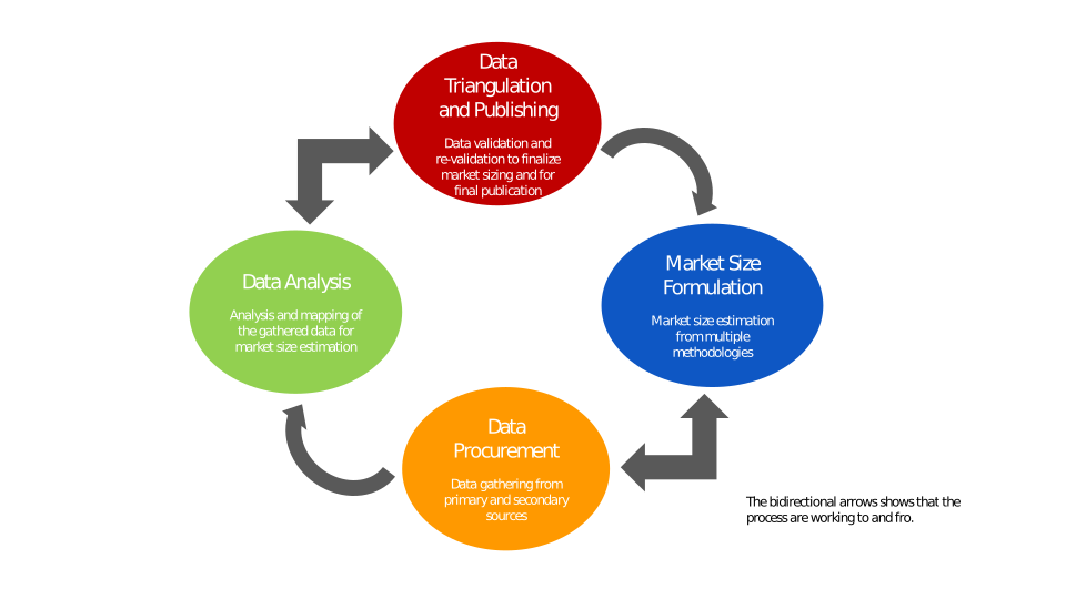
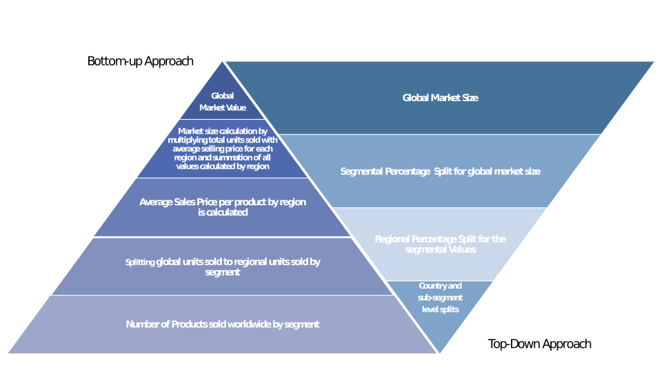
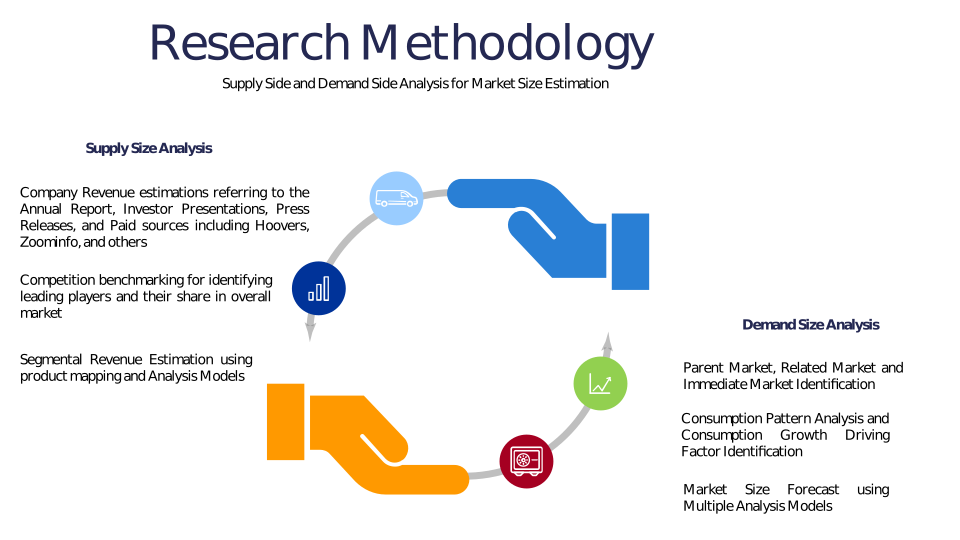
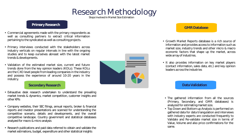
Chapter 3 Research Methodology
Chapter 4 Drone-Based Coral Bleaching Survey Market Overview
4.1 Introduction
4.1.1 Market Taxonomy
4.1.2 Market Definition
4.1.3 Macro-Economic Factors Impacting the Market Growth
4.2 Drone-Based Coral Bleaching Survey Market Dynamics
4.2.1 Market Drivers
4.2.2 Market Restraints
4.2.3 Market Opportunity
4.3 Drone-Based Coral Bleaching Survey Market - Supply Chain Analysis
4.3.1 List of Key Suppliers
4.3.2 List of Key Distributors
4.3.3 List of Key Consumers
4.4 Key Forces Shaping the Drone-Based Coral Bleaching Survey Market
4.4.1 Bargaining Power of Suppliers
4.4.2 Bargaining Power of Buyers
4.4.3 Threat of Substitution
4.4.4 Threat of New Entrants
4.4.5 Competitive Rivalry
4.5 Global Drone-Based Coral Bleaching Survey Market Size & Forecast, 2023-2032
4.5.1 Drone-Based Coral Bleaching Survey Market Size and Y-o-Y Growth
4.5.2 Drone-Based Coral Bleaching Survey Market Absolute $ Opportunity
Chapter 5 Global Drone-Based Coral Bleaching Survey Market Analysis and Forecast By Drone Type
5.1 Introduction
5.1.1 Key Market Trends & Growth Opportunities By Drone Type
5.1.2 Basis Point Share (BPS) Analysis By Drone Type
5.1.3 Absolute $ Opportunity Assessment By Drone Type
5.2 Drone-Based Coral Bleaching Survey Market Size Forecast By Drone Type
5.2.1 Fixed-Wing
5.2.2 Rotary-Wing
5.2.3 Hybrid
5.3 Market Attractiveness Analysis By Drone Type
Chapter 6 Global Drone-Based Coral Bleaching Survey Market Analysis and Forecast By Application
6.1 Introduction
6.1.1 Key Market Trends & Growth Opportunities By Application
6.1.2 Basis Point Share (BPS) Analysis By Application
6.1.3 Absolute $ Opportunity Assessment By Application
6.2 Drone-Based Coral Bleaching Survey Market Size Forecast By Application
6.2.1 Coral Reef Monitoring
6.2.2 Environmental Impact Assessment
6.2.3 Research and Development
6.2.4 Conservation Initiatives
6.2.5 Others
6.3 Market Attractiveness Analysis By Application
Chapter 7 Global Drone-Based Coral Bleaching Survey Market Analysis and Forecast By Sensor Type
7.1 Introduction
7.1.1 Key Market Trends & Growth Opportunities By Sensor Type
7.1.2 Basis Point Share (BPS) Analysis By Sensor Type
7.1.3 Absolute $ Opportunity Assessment By Sensor Type
7.2 Drone-Based Coral Bleaching Survey Market Size Forecast By Sensor Type
7.2.1 RGB Cameras
7.2.2 Multispectral Sensors
7.2.3 Thermal Sensors
7.2.4 LiDAR
7.2.5 Others
7.3 Market Attractiveness Analysis By Sensor Type
Chapter 8 Global Drone-Based Coral Bleaching Survey Market Analysis and Forecast By End-User
8.1 Introduction
8.1.1 Key Market Trends & Growth Opportunities By End-User
8.1.2 Basis Point Share (BPS) Analysis By End-User
8.1.3 Absolute $ Opportunity Assessment By End-User
8.2 Drone-Based Coral Bleaching Survey Market Size Forecast By End-User
8.2.1 Research Institutes
8.2.2 Government Agencies
8.2.3 Environmental NGOs
8.2.4 Aquariums and Marine Parks
8.2.5 Others
8.3 Market Attractiveness Analysis By End-User
Chapter 9 Global Drone-Based Coral Bleaching Survey Market Analysis and Forecast by Region
9.1 Introduction
9.1.1 Key Market Trends & Growth Opportunities By Region
9.1.2 Basis Point Share (BPS) Analysis By Region
9.1.3 Absolute $ Opportunity Assessment By Region
9.2 Drone-Based Coral Bleaching Survey Market Size Forecast By Region
9.2.1 North America
9.2.2 Europe
9.2.3 Asia Pacific
9.2.4 Latin America
9.2.5 Middle East & Africa (MEA)
9.3 Market Attractiveness Analysis By Region
Chapter 10 Coronavirus Disease (COVID-19) Impact
10.1 Introduction
10.2 Current & Future Impact Analysis
10.3 Economic Impact Analysis
10.4 Government Policies
10.5 Investment Scenario
Chapter 11 North America Drone-Based Coral Bleaching Survey Analysis and Forecast
11.1 Introduction
11.2 North America Drone-Based Coral Bleaching Survey Market Size Forecast by Country
11.2.1 U.S.
11.2.2 Canada
11.3 Basis Point Share (BPS) Analysis by Country
11.4 Absolute $ Opportunity Assessment by Country
11.5 Market Attractiveness Analysis by Country
11.6 North America Drone-Based Coral Bleaching Survey Market Size Forecast By Drone Type
11.6.1 Fixed-Wing
11.6.2 Rotary-Wing
11.6.3 Hybrid
11.7 Basis Point Share (BPS) Analysis By Drone Type
11.8 Absolute $ Opportunity Assessment By Drone Type
11.9 Market Attractiveness Analysis By Drone Type
11.10 North America Drone-Based Coral Bleaching Survey Market Size Forecast By Application
11.10.1 Coral Reef Monitoring
11.10.2 Environmental Impact Assessment
11.10.3 Research and Development
11.10.4 Conservation Initiatives
11.10.5 Others
11.11 Basis Point Share (BPS) Analysis By Application
11.12 Absolute $ Opportunity Assessment By Application
11.13 Market Attractiveness Analysis By Application
11.14 North America Drone-Based Coral Bleaching Survey Market Size Forecast By Sensor Type
11.14.1 RGB Cameras
11.14.2 Multispectral Sensors
11.14.3 Thermal Sensors
11.14.4 LiDAR
11.14.5 Others
11.15 Basis Point Share (BPS) Analysis By Sensor Type
11.16 Absolute $ Opportunity Assessment By Sensor Type
11.17 Market Attractiveness Analysis By Sensor Type
11.18 North America Drone-Based Coral Bleaching Survey Market Size Forecast By End-User
11.18.1 Research Institutes
11.18.2 Government Agencies
11.18.3 Environmental NGOs
11.18.4 Aquariums and Marine Parks
11.18.5 Others
11.19 Basis Point Share (BPS) Analysis By End-User
11.20 Absolute $ Opportunity Assessment By End-User
11.21 Market Attractiveness Analysis By End-User
Chapter 12 Europe Drone-Based Coral Bleaching Survey Analysis and Forecast
12.1 Introduction
12.2 Europe Drone-Based Coral Bleaching Survey Market Size Forecast by Country
12.2.1 Germany
12.2.2 France
12.2.3 Italy
12.2.4 U.K.
12.2.5 Spain
12.2.6 Russia
12.2.7 Rest of Europe
12.3 Basis Point Share (BPS) Analysis by Country
12.4 Absolute $ Opportunity Assessment by Country
12.5 Market Attractiveness Analysis by Country
12.6 Europe Drone-Based Coral Bleaching Survey Market Size Forecast By Drone Type
12.6.1 Fixed-Wing
12.6.2 Rotary-Wing
12.6.3 Hybrid
12.7 Basis Point Share (BPS) Analysis By Drone Type
12.8 Absolute $ Opportunity Assessment By Drone Type
12.9 Market Attractiveness Analysis By Drone Type
12.10 Europe Drone-Based Coral Bleaching Survey Market Size Forecast By Application
12.10.1 Coral Reef Monitoring
12.10.2 Environmental Impact Assessment
12.10.3 Research and Development
12.10.4 Conservation Initiatives
12.10.5 Others
12.11 Basis Point Share (BPS) Analysis By Application
12.12 Absolute $ Opportunity Assessment By Application
12.13 Market Attractiveness Analysis By Application
12.14 Europe Drone-Based Coral Bleaching Survey Market Size Forecast By Sensor Type
12.14.1 RGB Cameras
12.14.2 Multispectral Sensors
12.14.3 Thermal Sensors
12.14.4 LiDAR
12.14.5 Others
12.15 Basis Point Share (BPS) Analysis By Sensor Type
12.16 Absolute $ Opportunity Assessment By Sensor Type
12.17 Market Attractiveness Analysis By Sensor Type
12.18 Europe Drone-Based Coral Bleaching Survey Market Size Forecast By End-User
12.18.1 Research Institutes
12.18.2 Government Agencies
12.18.3 Environmental NGOs
12.18.4 Aquariums and Marine Parks
12.18.5 Others
12.19 Basis Point Share (BPS) Analysis By End-User
12.20 Absolute $ Opportunity Assessment By End-User
12.21 Market Attractiveness Analysis By End-User
Chapter 13 Asia Pacific Drone-Based Coral Bleaching Survey Analysis and Forecast
13.1 Introduction
13.2 Asia Pacific Drone-Based Coral Bleaching Survey Market Size Forecast by Country
13.2.1 China
13.2.2 Japan
13.2.3 South Korea
13.2.4 India
13.2.5 Australia
13.2.6 South East Asia (SEA)
13.2.7 Rest of Asia Pacific (APAC)
13.3 Basis Point Share (BPS) Analysis by Country
13.4 Absolute $ Opportunity Assessment by Country
13.5 Market Attractiveness Analysis by Country
13.6 Asia Pacific Drone-Based Coral Bleaching Survey Market Size Forecast By Drone Type
13.6.1 Fixed-Wing
13.6.2 Rotary-Wing
13.6.3 Hybrid
13.7 Basis Point Share (BPS) Analysis By Drone Type
13.8 Absolute $ Opportunity Assessment By Drone Type
13.9 Market Attractiveness Analysis By Drone Type
13.10 Asia Pacific Drone-Based Coral Bleaching Survey Market Size Forecast By Application
13.10.1 Coral Reef Monitoring
13.10.2 Environmental Impact Assessment
13.10.3 Research and Development
13.10.4 Conservation Initiatives
13.10.5 Others
13.11 Basis Point Share (BPS) Analysis By Application
13.12 Absolute $ Opportunity Assessment By Application
13.13 Market Attractiveness Analysis By Application
13.14 Asia Pacific Drone-Based Coral Bleaching Survey Market Size Forecast By Sensor Type
13.14.1 RGB Cameras
13.14.2 Multispectral Sensors
13.14.3 Thermal Sensors
13.14.4 LiDAR
13.14.5 Others
13.15 Basis Point Share (BPS) Analysis By Sensor Type
13.16 Absolute $ Opportunity Assessment By Sensor Type
13.17 Market Attractiveness Analysis By Sensor Type
13.18 Asia Pacific Drone-Based Coral Bleaching Survey Market Size Forecast By End-User
13.18.1 Research Institutes
13.18.2 Government Agencies
13.18.3 Environmental NGOs
13.18.4 Aquariums and Marine Parks
13.18.5 Others
13.19 Basis Point Share (BPS) Analysis By End-User
13.20 Absolute $ Opportunity Assessment By End-User
13.21 Market Attractiveness Analysis By End-User
Chapter 14 Latin America Drone-Based Coral Bleaching Survey Analysis and Forecast
14.1 Introduction
14.2 Latin America Drone-Based Coral Bleaching Survey Market Size Forecast by Country
14.2.1 Brazil
14.2.2 Mexico
14.2.3 Rest of Latin America (LATAM)
14.3 Basis Point Share (BPS) Analysis by Country
14.4 Absolute $ Opportunity Assessment by Country
14.5 Market Attractiveness Analysis by Country
14.6 Latin America Drone-Based Coral Bleaching Survey Market Size Forecast By Drone Type
14.6.1 Fixed-Wing
14.6.2 Rotary-Wing
14.6.3 Hybrid
14.7 Basis Point Share (BPS) Analysis By Drone Type
14.8 Absolute $ Opportunity Assessment By Drone Type
14.9 Market Attractiveness Analysis By Drone Type
14.10 Latin America Drone-Based Coral Bleaching Survey Market Size Forecast By Application
14.10.1 Coral Reef Monitoring
14.10.2 Environmental Impact Assessment
14.10.3 Research and Development
14.10.4 Conservation Initiatives
14.10.5 Others
14.11 Basis Point Share (BPS) Analysis By Application
14.12 Absolute $ Opportunity Assessment By Application
14.13 Market Attractiveness Analysis By Application
14.14 Latin America Drone-Based Coral Bleaching Survey Market Size Forecast By Sensor Type
14.14.1 RGB Cameras
14.14.2 Multispectral Sensors
14.14.3 Thermal Sensors
14.14.4 LiDAR
14.14.5 Others
14.15 Basis Point Share (BPS) Analysis By Sensor Type
14.16 Absolute $ Opportunity Assessment By Sensor Type
14.17 Market Attractiveness Analysis By Sensor Type
14.18 Latin America Drone-Based Coral Bleaching Survey Market Size Forecast By End-User
14.18.1 Research Institutes
14.18.2 Government Agencies
14.18.3 Environmental NGOs
14.18.4 Aquariums and Marine Parks
14.18.5 Others
14.19 Basis Point Share (BPS) Analysis By End-User
14.20 Absolute $ Opportunity Assessment By End-User
14.21 Market Attractiveness Analysis By End-User
Chapter 15 Middle East & Africa (MEA) Drone-Based Coral Bleaching Survey Analysis and Forecast
15.1 Introduction
15.2 Middle East & Africa (MEA) Drone-Based Coral Bleaching Survey Market Size Forecast by Country
15.2.1 Saudi Arabia
15.2.2 South Africa
15.2.3 UAE
15.2.4 Rest of Middle East & Africa (MEA)
15.3 Basis Point Share (BPS) Analysis by Country
15.4 Absolute $ Opportunity Assessment by Country
15.5 Market Attractiveness Analysis by Country
15.6 Middle East & Africa (MEA) Drone-Based Coral Bleaching Survey Market Size Forecast By Drone Type
15.6.1 Fixed-Wing
15.6.2 Rotary-Wing
15.6.3 Hybrid
15.7 Basis Point Share (BPS) Analysis By Drone Type
15.8 Absolute $ Opportunity Assessment By Drone Type
15.9 Market Attractiveness Analysis By Drone Type
15.10 Middle East & Africa (MEA) Drone-Based Coral Bleaching Survey Market Size Forecast By Application
15.10.1 Coral Reef Monitoring
15.10.2 Environmental Impact Assessment
15.10.3 Research and Development
15.10.4 Conservation Initiatives
15.10.5 Others
15.11 Basis Point Share (BPS) Analysis By Application
15.12 Absolute $ Opportunity Assessment By Application
15.13 Market Attractiveness Analysis By Application
15.14 Middle East & Africa (MEA) Drone-Based Coral Bleaching Survey Market Size Forecast By Sensor Type
15.14.1 RGB Cameras
15.14.2 Multispectral Sensors
15.14.3 Thermal Sensors
15.14.4 LiDAR
15.14.5 Others
15.15 Basis Point Share (BPS) Analysis By Sensor Type
15.16 Absolute $ Opportunity Assessment By Sensor Type
15.17 Market Attractiveness Analysis By Sensor Type
15.18 Middle East & Africa (MEA) Drone-Based Coral Bleaching Survey Market Size Forecast By End-User
15.18.1 Research Institutes
15.18.2 Government Agencies
15.18.3 Environmental NGOs
15.18.4 Aquariums and Marine Parks
15.18.5 Others
15.19 Basis Point Share (BPS) Analysis By End-User
15.20 Absolute $ Opportunity Assessment By End-User
15.21 Market Attractiveness Analysis By End-User
Chapter 16 Competition Landscape
16.1 Drone-Based Coral Bleaching Survey Market: Competitive Dashboard
16.2 Global Drone-Based Coral Bleaching Survey Market: Market Share Analysis, 2023
16.3 Company Profiles (Details – Overview, Financials, Developments, Strategy)
16.3.1 DJI (SZ DJI Technology Co. Ltd.)
16.3.2 Parrot SA
16.3.3 AeroVironment Inc.
16.3.4 AgEagle Aerial Systems (senseFly)
16.3.5 Quantum-Systems GmbH
16.3.6 Delair SAS
16.3.7 Teledyne FLIR LLC
16.3.8 MicaSense Inc.
16.3.9 Wingtra AG
16.3.10 Autel Robotics
16.3.11 Swift Navigation
16.3.12 Skydio Inc.
16.3.13 Terra Drone Corporation
16.3.14 Trimble Inc.
16.3.15 Insitu Inc. (a Boeing company)
Methodology
Related Reports
Some other reports from this category!


Our Clients